Download
1 / 35
550 likes | 1.52k Views
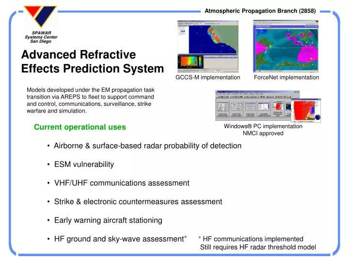
Advanced Refractive Effects Prediction System. GCCS-M implementation. ForceNet implementation. Models developed under the EM propagation task transition via AREPS to fleet to support command and control, communications, surveillance, strike warfare and simulation. Current operational uses

E N D
Advanced Refractive Effects Prediction System GCCS-M implementation ForceNet implementation Models developed under the EM propagation task transition via AREPS to fleet to support command and control, communications, surveillance, strike warfare and simulation. • Current operational uses • Airborne & surface-based radar probability of detection • ESM vulnerability • VHF/UHF communications assessment • Strike & electronic countermeasures assessment • Early warning aircraft stationing • HF ground and sky-wave assessment* Windows® PC implementation NMCI approved * HF communications implemented Still requires HF radar threshold model
AREPS Features • User interface • Microsoft Windows 95 - XP • GCCS-M / NITES II • Composable ForceNet • FalconView • Network configurable • Programmatics • DII-COE compliant Windows 2000 • NMCI approved • Government owned • License free • Tri-service • Technical support • Internet / SIPRNET homepage • 24/7 METOC help-desk • FAQ’s • Software updates • On-line trouble reporting system • Extensive built in help • Formal school house training • User’s manual and other DII-COE • documentation • 2 MHz - 57 GHz frequency range • OpNav authorized propagation model • Range/bearing dependent environment • Upper-air observations • Surface observations • Built-in climatology • Mesoscale meteorological models • Range and bearing variable terrain • Rough ocean-surface • Surface clutter • Fixed or user-specific ground types • Automatic DTED level 0, 1, & 2 • User maintained EM system database • Radars • Communication systems • ESM receivers • Targets • Classified master database available
FalconView Various AREPS implementations GCCS-M NITES-II Common Operating Picture Personal -PC Pocket-PC • Composable ForceNet • (Current Installs) • CTF-74 • CTF-72 • CTF-72.2 • USS Blue Ridge
AREPS Windows® Personal Computer Implementation DTED Terrain METOC in numerous formats Observations / Mesoscale Models / Climatology EM systems Operator interface Numerous decision aids
Height versus Range Coverage Display Personal annotation capability Right click on legend to change colors Right click on picture for popup menus
Range/Height Displays Right click on picture for popup menus Scroll bar to change height/range
AREPS toolbar FalconView Interface FalconView display Multiple emitters Surface-based duct skip-zone DTED terrain Import various EOB files All normal AREPS displays Range & bearing environment data
Area Display Change targets, radar POD, ESM receiver, Comm receiver, & display height on-the-fly Mouse move shows location and DTED terrain elevations.
Maximum Range Display Multiple targets, ESM, and Comm receivers Change POD on-the-fly Table format Bargraph format
Troposphere Raytrace • Range / bearing dependent terrain (DTED data) • Range / bearing dependent atmosphere • Altitude errors • Optional internal data output - • angles, ranges, heights, times, etc.
HF communications • Used to assess HF sky-wave in both area and point-to-point display • Used to assess HF combined sky-wave and ground-wave • Propagation loss, electric field, signal-to-noise, received power, MUF,LUF,FOT, terrain masking. • Reads environment from a file created with the environment program and ionospheric data obtained via AREPS homepage. • Reads terrain from DTED or a custom file.
HF Ionosphere Raytrace Communications & Radar • Multiple azimuths, elevations, • and frequencies • Ray display - elevation and azimuth • Plasma frequency contours in • vertical and horizontal planes • Contours of F2 and E region • critical parameters • Frequency homing • Ionogram • Models • Jones-Stephenson 3-D ionosphere • with geo-magnetic field • Parameterized Ionosphere Model • (PIM 1.7) • Future • International Reference Ionosphere • User plug-ins
AREPS Server Mode • Runs on a background server • Uses COAMPS grid data from DAMPS • No AREPS operator intervention • Accessed via application GUI • Composable ForceNet • (Current Installs) • CTF-74 • CTF-72 • CTF-72.2 • USS Blue Ridge Homeland Defense Proposal effort (SSC 246 Command and Control Technology and Experimentation Division) Emergency Response UHF communications East County San Diego
Standard Project Window Research Project Window (full access to APM) Numerous right-click popup menus
Automode Menu Window Run multiple projects in batch “hands-off” process
EM System Database • ASCII text • Easily transportable • User maintained • Common master capable
System Input/Editing Windows ESM receivers HF to EHF Communications Targets Radars Platforms
Numerous Popup Menu Options Click on label to change units Click on picture for display options Click on input field for help Click on legend to change colors
Digital Terrain Elevation Data File Manager Can use level 0, 1, and 2 DTED data
Message & Error Window Details View (message to technical support) Description View (message to user) New - “Don’t show option”
Numerous Environment Data Sources Local Observations • WMO Code • Climatology • Metcast/JMV • Custom Columns • COAMPS / MM5 JAAWIN Homepage Internet / SIPRNET Built-in Surface and Upper-air Climatology DoD Homepages DAMPS Homepage Metcast
Environmental Input WMO Code Import Example Source Joint Air Force and Army Weather Information Network Example Source Military homepages
Upper-air Climatology “Zoomable” map for easier station selection Numeric and graphic profile depiction Graphic depiction of various monthly statistics
Surface Climatology • “Zoomable” map for easier area selection • Surface values • Pressure • Air temperature • Relative humidity • Wind speed • Wind direction • Evaporation duct heights • Absolute humidity • Air-sea temp difference • Rain rates Graphic depiction of various monthly statistics Calculated evaporation duct profiles from surface climatology values
Environmental Input Custom Column Method Example Custom Column Sources
AREPS On-line Help Opportunities E-mail Internet: areps@spawar.navy.mil Homepages Internet: http://sunspot.spawar.navy.mil Internet: http://mskc.spawar.navy.mil
Summary • SSC San Diego, Atmosphere Propagation Branch has over 55 years of expertise in propagation modeling, environmental data assimilation, and C4I decision aids. • APM is the only N096/N61 accredited EM (100 MHz – 57 GHz) propagation model • APM and AREPS are elements of the Defense Modeling and Simulation Office (DMSO) and Navy Modeling & Simulation Management Office (NAVMSMO) library • AREPS is a Functional Area Manager (FAM) certified application within the Department of the Navy’s Application and Database Management System (DADMS). • AREPS is NMCI certified • AREPS is NATO approved, Military Committee Meteorological Group/WG - Battle Area Meteorological Systems and Support plus with Partners When can we meet to discuss your needs in greater detail?
How to Contact Us Commercial(619) 553-1423 DSN553-1423 Facsimile(619) 553-1417 E–mail AREPSareps@spawar.navy.mil areps@spawar.navy.smil.mil Public Internet - http://sunspot.spawar.navy.mil