Download
1 / 1
10 likes | 142 Views
Intensive and Extensive Fire Properties in Emission Models. Information Requirements for accurate Modeling of Biomass Burning Emissions. Edward J. Hyer Jeff S. Reid Naval Research Laboratory Marine Meteorology Division Monterey, CA, USA edward.hyer@nrlmry.navy.mil.

E N D
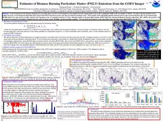
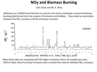
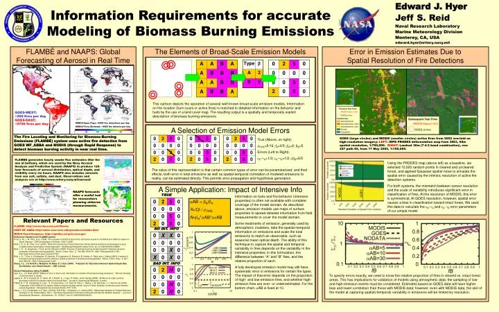
Intensive and Extensive Fire Properties in Emission Models Information Requirements for accurate Modeling of Biomass Burning Emissions Edward J. Hyer Jeff S. Reid Naval Research Laboratory Marine Meteorology Division Monterey, CA, USA edward.hyer@nrlmry.navy.mil FLAMBÉ and NAAPS: Global Forecasting of Aerosol in Real Time The Elements of Broad-Scale Emission Models Error in Emission Estimates Due to Spatial Resolution of Fire Detections This cartoon depicts the operation of several well-known broad-scale emission models. Information on fire location (burn scars or active fires) is matched to detailed information on fire behavior and fuels by the use of a land cover map. The resulting output is a spatially and temporally explicit description of biomass burning emissions. GOES-WEST: ~200 fires per day GOES-EAST: ~2750 fires per day MODIS-Aqua (Top): ~8000 fire detections per day MODIS-Terra (Bottom): ~4000 fire detects per day A Selection of Emission Model Errors The Fire Locating and Monitoring for Biomass-Burning Emissions (FLAMBÉ) system uses active fire detection from GOES WF_ABBA and MODIS (through Rapid Response) to detect biomass burning activity in near real time. GOES (large circles) and MODIS (smaller circles) active fires from 2002 overlaid on high-resolution imagery: LEFT: INPE PRODES deforestation map from 2003, 60m spatial resolution, 1:700,000. RIGHT: Landsat 30m (7-4-2 band combination), row 227 path 65, from 17 May 2003, 1:100,000. True (Above, on right): rFIRE=5/16; fB=3/5; bA=2; bB=5 Errors (Left to Right): eB→A=1/3; eA→B=1/2; ebB=6/5 FLAMBE generates hourly smoke flux estimates (like the one at bottom), which are used by the Navy Aerosol Analysis and Prediction System (NAAPS) to produce 120-hour forecasts of aerosol distribution, optical depth, and visibility every six hours. NAAPS also includes aerosols from sea salt, sulfate, and dust. Observations and analyses are at http://www.nrlmry.navy.mil/aerosol/ Using the PRODES map (above left) as a baseline, we selected 10,000 random points in cleared and uncleared forest, and applied Gaussian spatial noise to simulate the spatial error caused by the intrinsic resolution of active fire detection systems. For both systems, the mismatch between sensor resolution and the scale of variability introduces significant error in classification of fires. At the resolution of MODIS, this error is symmetrical. At GOES resolution, however, spatial error causes a bias in classification toward intact forest. We used this data to calculate the eB→A and eA→B error parameters of our simple model. The value of this representation is that certain common types of error can be parameterized, and their effects, both error in total emissions as well as spatial-temporal correlation of modeled emissions to reality, can be estimated directly. This permits error propagation and hypothesis generation. A Simple Application: Impact of Intensive Info NAAPS forecasts offer a useful tool for researchers planning airborne measurements. TRUE Information on fuels and fire behavior (intensive properties) is often not available with complete coverage of the model domain. As described above, emission models use maps of surface properties to spread detailed information from field measurements to cover the model domain. Some treatments of emission, generally used by atmospheric modelers, take the spatial+temporal information on emissions and scale the total emissions to match an observable, such as seasonal mean optical depth. The ability of this technique to capture the spatial and temporal variability in fires depends on the variability in fire intensive properties; in this formulation, the difference between “A” and “B” fires, and the relative proportion of each. A fully developed emission model may still have systematic error in emissions for certain fire types. The impact of that error depends on the proportion of high- and low-emission fires, and whether high-emission fires are over- or underestimated. For the bottom chart, aAB is fixed at 10. aAB = bB/bA X=Sb / rFIRE N=bA*aAB*eaAB Relevant Papers and Resources FLAMBÉ: http://www.nrlmry.navy.mil/flambe GOES WF_ABBA: http://cimss.ssec.wisc.edu/goes/burn/wfabba.html MODIS Rapid Response: http://rapidfire.sci.gsfc.nasa.gov/ References Related to the FLAMBÉ system: Prins, E. M., J. M. Feltz, et al. (1998). "An overview of GOES-8 diurnal fire and smoke results for SCAR-B and 1995 fire season in South America." JGR-Atmospheres 103(D24): 31821-31835. Reid, J. S., E. M. Prins, et al. (2004). "Real-time monitoring of South American smoke particle emissions and transport using a coupled remote sensing/box-model approach." Geophysical Research Letters 31(6): doi:10.1029/2003GL018845. Reid, J. S., R. Koppmann, T. Eck, and D. Eleuterio (2005) “A review of biomass burning emissions part II: Intensive physical properties of biomass burning particles”, Atmos. Chem. Phys., 5, 799–825, SRef-ID: 1680-7324/acp/2005-5-799. http://www.atmos-chem-phys.org/acp/5/799/ Reid, J. S., T. Eck, S. Christopher, O. Dubovik, R. Koppmann, D. Eleuterio, B. Holben, E. Reid, and J. Zhang (2005) “A review of biomass burning emissions part III: Intensive optical properties of biomass burning particles”, Atmos. Chem. Phys., 5, 827–849, SRef-ID: 1680-7324/acp/2005-5-827. http://www.atmos-chem-phys.org/acp/5/827/ Zhang, J.L., J.S. Reid,D.L. Westphal, N. Baker, E.J. Hyer (2008). “A System for Operational Aerosol Optical Depth Data Assimilation over Global Oceans”, JGR in press. Recent Publications Using FLAMBÉ: Hyer, E.J., J.S. Reid (2008). “Effects of error in land cover information on models of biomass-burning emissions.” Remote Sensing of Environment, in review. Lapina, K., R. E. Honrath, R. C. Owen, M. V. Martin, E. J. Hyer, P. Fialho, and F. Barata (2008). “Evidence of a late-summer decrease in NOx/CO emission ratios from boreal fires”, Journal of Geophysical Research, in press. O'Neill, N. T., M. Campanelli, A. Lupu , S. Thulasiraman, J. S. Reid, M. Aube, L. Nearly, J. W. Kaminski, J. C. McConnell (2006). “Evaluation of the GEM-AQ air quality model during the Quebec smoke event of 2002: Analysis of extensive and intensive optical disparities”, Atmospheric Environment 40(20):3737-3749. Wang, J., S.A. Christopher, U.S. Nair, J.S.Reid, E.M.Prins, J.Szykman, J.L. Hand (2006), “Mesoscale transport of Central American Transport to the United States, Part 1: Top Down Assessment of Emission Strength and Diurnal Variation Impacts”, Journal of Geophysical Research - Atmospheres, 111, D05S17, doi:10.1029/2005JD006416. NO INT. INFO BAD INT. INFO To specify errors exactly, we need to know the relative proportion of fires in cleared vs. intact forest areas. This has implications for validation of models using atmospheric data; the sampling of low- and high-emission events must be considered. Estimates based on GOES data will have higher bias and lower correlation than those with MODIS data; however, even with MODIS data, the skill of the model at capturing spatial(/temporal) variability in emissions will be limited by resolution.