Download
1 / 30
300 likes | 435 Views
GEMS (i) Global Earth-system Monitoring using Space and in-situ data. GEMS: Extend the Data Assimilation system at ECMWF to describe atmospheric dynamics, thermodynamics and composition: GREEHOUSE GASES REACTIVE-GASES AEROSOL

E N D
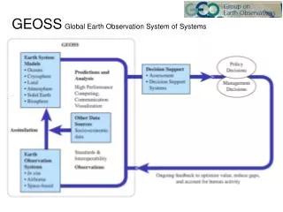
GEMS (i) Global Earth-system Monitoring using Space and in-situ data GEMS: Extend the Data Assimilation system at ECMWF to describe atmospheric dynamics, thermodynamics and composition: • GREEHOUSE GASES • REACTIVE-GASES • AEROSOL • Collaborate closely with 3 related EU Framework 6 funded projects • GEOLAND: Model and assimilate data on the Land Biosphere and global carbon cycle, using best available met input. • MERSEA: Model and assimilate upper-ocean, incl. Ocean-colour to estimate ocean carbon uptake, using best available met input. • HALO: Harmonisation of Atmosphere, Ocean, Land Projects • By 2008 • Operational GEMS system; 10-year reanalysis of EOS / ENVISAT era • Best possible estimates of trace constituent sources /sinks / transport
GEMS (ii) Global Earth-system Monitoring using Space and in-situ data • GEMS data assimilation projects • Monitor-GREEHOUSE GASES: Monitor seasonal variations of non-reactive Greenhouse Gases such as CO2, CH4, N2O (+CO) • Monitor-REACTIVE-GASES: Monitor ozone and its precursors, and sulphate aerosol and its precursors. • Monitor-AEROSOL: Model and assimilate global aerosol information • Cross-Cutting projects • SYSTEM-INTEGRATION Integrate the data-assimilation sub- projects in a unified pre-operational system • RETROSPECTIVE REANALYSIS Validate the pre-operational system through observational verification of retrospective analyses for the "EOS - ENVISAT" epoch 2000-2007, and perhaps for the epoch 1947-2007.
GEMS (iii) Global Earth-system Monitoring using Space and in-situ dataRelated Land & Ocean Projects • GEOLAND: Model and assimilate information on the Land Biosphere and carbon cycle. • MERSEA Model and assimilate upper-ocean, to estimate ocean carbon uptake.
GEMS-GREEHOUSE GASES: • Monitor seasonal variations of non-reactive Greenhouse Gases such as CO2, CH4, N2O, CO • Heritage: COCO (FP5) • Instruments: AIRS, SCIAMACHY, IASI, OCO • Data Mgt • R/T develop from COCO • Modelling develop from COCO • Sources / Sinks Current Methods + 3D-InVar; variational method using CTM very close to ECMWF model • Data Assim. ECMWF & …. • Validation build on COCO validation team
CO2 assimilation -Troposphere CO2 tropospheric columns are being assimilated from AIRS infrared observations. Monthly mean distribution for May 2003 is shown on the left, and the upper boundary for the error estimate is shown on the right.
CO2 assimilation - Stratosphere First analysis of stratospheric CO2 shows Brewer-Dobson type of circulation. Variability is also much smaller than in troposphere.
GEMS REACTIVE-GASES [ and Forecast Chemical Weather] • Deliverables • Determine the magnitude and location of stratospheric / tropospheric ozone exchanges • Determine the modes and magnitudes of intercontinental transport of ozone and other constituents. • Provide global Chemical Weather Forecasts including UV-B forecasts, plus initial and boundary conditions for regional Chemical Weather Forecasts. • Data Assimilation Approach • Stream 1: 4d Var with simplified chemistry to retrieve Ozone (12hr window). • Stream 2: Chemical Transport Model uses Atmospheric transport from stream 1 to assimilate / transport up to 50 species. A priori surface flux fields specified from RIVM-EDGAR database • Instruments: UARS, AIRS, MIPAS, SCIAMACHY, GOMOS, SEVIRI, OMI, TES • R/T & Retrievals • Modelling • Sources / Sinks • Data Assim. • Validation
Assimilation of ozone data from MIPAS No MIPAS MIPAS TOMS verif Inclusion of ozone profiles from MIPAS (ENVISAT) improves substantially the representation of the ozone field in the ECMWF model
Monitor-AEROSOL: • Model and assimilate global aerosol information • Heritage: - • Instruments: MERIS, MODIS x 2, MISR, SEAWIFS, POLDER • Data Mgt tbd • R/T “ • Modelling “ • Sources/ Sinks “ • Data Assim. “ • Validation “
Aerosol modelling and assimilation is an emerging issue for NWP • ‘HIRS channels sensitive to the surface temperature, lower tropospheric temperature, and moisture are subject to a 0.5 K or more reduction in the brightness temperature during heavy dust loading conditions. (Weaver, Joiner, Ginoux JGR April 2003) • Aerosol is the biggest source of error in ECMWF clear-sky radiation computations (JJ Morcrette, pers.comm.)
MERSEA collaboration • Deliverables • Monthly estimates of ocean carbon uptake through assimilation of data on the dynamics and biology of the upper-ocean. • Instruments: • QSCAT, ASCAT, RA2, JASON, MERIS, MODIS, MISR, SeaWifs, • R/T & Retrievals • Satellite agencies' baseline meteo retrievals; • Modelling • Sources/ Sinks • Data Assim. • Validation
GEOLAND collaboration • Deliverables • 2006 Stage I: Prototype offline assimilation system of remote sensing products and land surface model(s) to provide boundary conditions for the GHG and AEROSOL sub-projects. Data assimilation products: Soil moisture, LAI, biomass, snow, fluxes of carbon, water and energy. • 2008 Stage II: As above but with refined assimilation scheme and land surface model(s) and below- and above-ground carbon storage as deliverables. • Data Assimilation Approach • Build on existing FP5 projects (ELDAS, CAMELS, Land-SAF); model and product benchmarking; off-line assimilation with several models (ISBA-A-gs, MOSES, C-TESSEL). Transition from assimilation of derived geophysical products (Stage I) to top of the atmosphere radiances (Stage II). • Instruments: • AVHRR, ATSR, GRACE, POLDER, VEGETATION, SEVIRI, MERIS, MISR, MODIS, SMOS • R/T & Retrievals • Modelling • Data Assim. • Validation
Observations driving soil moisture correction MERIS / METEOSAT/MSG SMOS AMSR Synops data precipitation radiation Land Missions, Modelling, Assimilation Several missions will enable an improvement of the ECMWF soil moisture and vegetation Observations driving The land model Atmosphere/Land / biosphere model + 1DVAR assimilation soil moisture/ vagetation
CRU/Hadley Centre http:///www.cru.uea.ac.uk/cru/info/warming GEMS Reanalysis Component Trends in ERA-40 ERA-40
Computing Power to use the Satellites • Full exploitation of the huge investments in space hardware requires appropriate investment in • computing power • advanced data-assimilation systems. • High spatial resolution (I.e. heavy computing power) is vital for the accuracy of both assimilation and forecasts • Japan has invested $400M in the Earth Simulator computer (40Tflop peak, 12Tflop sustained, installed 2002) • ECMWF invests ~£12M annually in HPC and ancillary equipment (2004 will see Blue Storm - 25Tflop peak, 2.5Tflop sustained) • European, US and Japanese Numerical-Weather-Prediction & Climate-modelling centres each have annualised investments of £3 – 10M
The GEMS Partnerships • GEMS partnerships include • European space agencies • Leading in-situ observational teams • Leading modelling and assimilation teams • Leading inverse-modelling teams • GEMS will have strong support from GAW, GCOS, WCRP… • GEMS will build on examples of successful EU-funded partnerships such as for ERA-40, PRISM, ELDAS, ACCENT.. • GEMS will have important spin-offs for Numerical Weather Prediction
Cost-effective information provision in a Numerical Weather Prediction (NWP) setting • Policymakers’ key global environmental information needs cannot be met without an Earth-system modelling and data assimilation capability. • Numerical Weather Prediction Centres will exploit most of the new instruments anyway, for their own purposes of forecasting weather & short-term climate variations. • To achieve good estimates of T, q, O3, ocean stress…., NWP centres must do a superb job on key tasks • Calibration • Channel selection • Cloud detection… • These tasks are essential pre-requisites to meeting policymakers’ needs • With modest additional effort, NWP centres can do a thorough exploitation and validation of the satellite data for weather and for environmental purposes. • REMARK: important pay-offs for NWP will include better models, better assimilations… The approach outlined above is one of the best ways to sharpen the performance of the NWP & Climate forecast systems
Observations driving soil moisture correction MERIS / METEOSAT/MSG SMOS AMSR Synops data precipitation radiation Land Missions, Modelling, Assimilation Several missions will enable an improvement of the ECMWF soil moisture and vegetation Observations driving The land model Atmosphere/Land / biosphere model + 1DVAR assimilation soil moisture/ vagetation
Monitor-AEROSOL: • Model and assimilate global aerosol information • Heritage: - • Instruments: MERIS, MODIS x 2, MISR, SEAWIFS, POLDER • Data Mgt tbd • R/T “ • Modelling “ • Sources/ Sinks “ • Data Assim. “ • Validation “
Monitor-GREEHOUSE GASES: • Monitor seasonal variations of non-reactive Greenhouse Gases such as CO2, CH4, N2O, CO • Heritage: COCO (FP5) • Instruments: AIRS, SCIAMACHY, IASI, OCO • Data Mgt ECMWF • R/T LMD & ECMWF • Modelling ECMWF & UKMO • Sources / Sinks • Data Assim. ECMWF & UKMO • Validation MPI-BG, LSCE, F.U.Amst. U.Tuscia, NUI_G
GEMSGlobal Earth-system Monitoring using Space and in-situ data GEMS: Build a Data Assimilation system at ECMWF (at lower than operational resolution) which extends the medium range system to assimilate • GREEHOUSE GASES • REACTIVE-GASES • AEROSOL • Operational by 2008 • Deliver a 10-year reanalysis of the EOS / ENVISAT era • Collaborate with 3 EU Framework 6 funded projects • GEOLAND: Model and assimilate data on the Land Biosphere and global carbon cycle. • MERSEA: Model and assimilate upper-ocean, incl. Ocean-colour to estimate ocean carbon uptake. • HALO: Harmonisation of Atmosphere, Ocean, Land Projects to deliver the best possible description of atmosphere dynamics, thermodynamics and composition.
Global Earth-system Monitoring using Space and in-situ data: GEMS GEMS Monitoring sub-projects • GREEHOUSE GASES: Monitor seasonal variations of non-reactive Greenhouse Gases such as CO2, CH4, N2O, CO • REACTIVE-GASES: Monitor ozone and its precursors, and sulphate aerosol and its precursors. • AEROSOL: Model and assimilate global aerosol information • SYSTEM-INTEGRATION & RETROSPECTIVE REANALYSIS:- Integrate the above projects in a pre-operational system, and validate through retrospective analyses • LAND: Model and assimilate data on the Land Biosphere and carbon cycle. • UPPER-OCEAN incl. OCEAN-COLOUR: Model and assimilate upper-ocean, to estimate ocean carbon uptake. Much important work already in progress!
The 1979 Convention on Long-range Transboundary Air Pollution: History • 1960s: Scientists show how sulphur emissions in continental Europe led to acidification of Scandinavian lakes. • 1972-77: After 1972 UN Stockholm Conference on Human Environment, studies confirm that air pollutants could travel thousands of kilometres before deposition and damage occurred • 1979: Convention on Long-range Transboundary Air Pollution signed by 34 Governments and the European Community – the first international legally binding instrument to deal with problems of air pollution on a broad regional basis. • The Convention set up an institutional framework bringing together research and policy. Continuing work has led to the development of 8 further protocols on different pollutants.
CARBO_EUROPE Network
Halloween Storm viewed from above Greenland 24-hour loop in steps of 3 hours 12z on 29/10 /00 to 12Z on 30/10/00 Ozone isopleth - f(p) - is colour-coded by temp. Yellow is warm Meteosat imagery shown below the ozone
Trends ERA-40 Jones et al. Land Parker et al. Sea Folland et al. (2002)
Time series of MSU-2 brightness-temperature anomaly (K), from Wentz and colleagues Image produced by Remote Sensing Systems and sponsored by NOAA Climate and Global Change Program Trends ERA-40