Download
1 / 13
130 likes | 233 Views
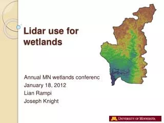
AIMS use of Lidar. Primary uses. Contour creation DTM/DSM generation Ortho photo rectification Floodplain determination. Secondary Uses. Building h eight estimates Height returned via IMS on point and parcel Assignment of elevation to sewer manholes. Unusual uses.

E N D
Primary uses • Contour creation • DTM/DSM generation • Ortho photo rectification • Floodplain determination
Secondary Uses • Building height estimates • Height returned via IMS on point and parcel • Assignment of elevation to sewer manholes
Unusual uses • Historic trail identification • citizen was able to determine the elevations in an area and suggest alternative higher locations for a proposed cell tower • Stormwater trace • “Change detection” difference • Vegetation/Tree Canopy identification
Veg Replacement Options • Heads up digitizing/updating of existing • Use of feature analyst • Infrared – usually leaf off • Use of Lidar analyst • Use of classification • Use of height differences • Use of return number • Use of LAStools
Preview of veg • LAS To Multipoint • Aggregate Points to Polygons • Cleanup – dissolving, simplifying, removing spikes, smoothing, etc. • QC
Tools to be aware of • http://www.Lastools.org
Tools to be aware of • http://resources.arcgis.com/en/communities/3d/
Other ideas • Classify bldg and veg points in LAS • Solar potential utilizes aspect • Line of sight analysis • Terrestrial Lidar – purchased by Crime Lab? • Mobile Lidar – useful for street inventories