Download
1 / 16
160 likes | 175 Views
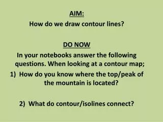
Lesson 25 What is a contour map?. There are many kinds of maps. The maps we use most often are surface maps. A surface map is a drawing that shows all or part of the earth’s surface. The main problem with a surface map is that it is flat.

E N D
Lesson 25 What is a contour map?
There are many kinds of maps. The maps we use most often are surface maps. A surface map is a drawing that shows all or part of the earth’s surface. The main problem with a surface map is that it is flat.
The earth’s surface is not at all flat. It has hills, mountains, plateaus, valleys and oceans. We can’t see those on a surface map.
The different parts of the earth’s surface are at different heights or elevations. The elevation of the ocean is 0. This is called sea level.
The rest of the earth’s surface is measured from sea level. This means that all elevations are measured in feet or meters above or below sea level.
The question is, how can a flat map show elevations???? Some maps use colors. Some use shading. However, such maps give only a general idea about the surface.
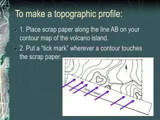
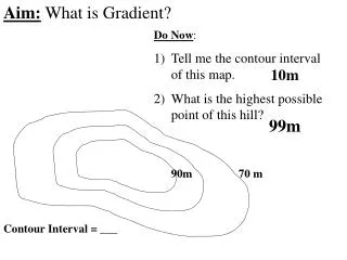
There is a special map called a contour map. Contour means shape. A contour map shows the true shape of the land. It also shows elevations and changes in elevations.
A contour map shows shape and elevation by means of contour lines. A contour line is a line that connects points that are at the same elevation. -every point on a contour line is at the same elevation.
-several contour lines make up a contour map. -the difference in elevation between two neighboring contour lines is called the contour interval of the map.
Contour lines that are far apart indicate that the land is fairy flat, or has a gentle slope Contour lines that are close together show that the land is hilly, or has a steep slope.
Farther apart means…….. Close together means…...
You must climb to the top of this hill. Will you choose the green arrow area or the red? Why?
A hilltop is enclosed by a single contour line. The exact elevation of a hilltop is shown by a small triangle beside the true elevation of the hill. The elevation of this peak is 118 meters. 118