Download
1 / 23
230 likes | 331 Views
High-Resolution RUC CAPE Values and Their Relationship to Right Turning Supercells. By: Andy Mair Mentor: Dr. William A. Gallus Jr . Department of Geological and Atmospheric Sciences Iowa State University, Ames, IA. Introduction. Supercell movement important to severe weather prediction

E N D
High-Resolution RUC CAPE Values and Their Relationship to Right Turning Supercells By: Andy Mair Mentor: Dr. William A. Gallus Jr. Department of Geological and Atmospheric Sciences Iowa State University, Ames, IA
Introduction • Supercell movement important to severe weather prediction • Storm Chasing • Goal: Find a link between CAPE and right turning supercells
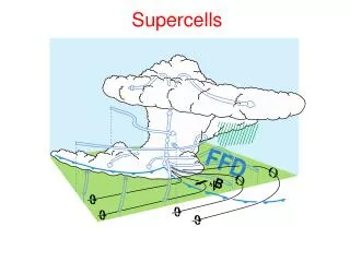
Terminology • CAPE = Convective Available Potential Energy -Energy for convection • RUC = Rapid Update Cycle - Computer model that runs hourly • GMT Time (z)= Standard time across the world (-6 hrs in Central time zone) • Right Turning Supercells
Right Turning Supercells B A A 248 O hr 30 min 270-248 = 22 C B 270 A 1 hr
Previous Research • Very little research • Bunkers Theory (1999) • Few older methods
Hypothesis • A supercell will become a right turning supercell due to mesocyclone strengthening. Therefore, CAPE should increase when a supercell right turns because CAPE has been shown to strengthen the mesocyclone.
Methodology • Data collected from June 2008 • Anywhere in US, mainly in southern midwest • Prevent Changes in RUC • 13 km High Resolution RUC • 82 Cases, 54 straight path supercells, 28 right turning cases
Methodology- Initiation/ Dissipation • Initiation when storm shows 40 dBZ reflectivity • Dissipation- - Storm falls below 40 dBZ - Storm merges with another storm
Methodology – Tracking/ Turning • Turning if 20 degree change in storm motion vector observed • Determined using GR2 Analyst storm motion • Left turners were not used • Collected right turning and straight path storms • Collected data every half hour
Methodology- Collecting CAPE • Used Surface Based CAPE • RUC downloaded from NCDC NOMADS site • Converted and used in Grads • Used CAPE value on the hour • When in between hours averaged hour before and hour after
Observations- Non turners • Very diverse data • Average initiation CAPE: 1351 J/kg • Average Dissipation CAPE: 1215 J/kg
Observations- Right Turners • CAPE values fall approximately 2 hours before turning • Initiation CAPE : 1953 J/kg • Dissipation CAPE : 1220 J/kg • Average CAPE drop of 733 J/kg
Conclusions • Right turners initialize in higher CAPE values • Right turners CAPE values fall 1-2 hours prior to turning • Original hypothesis was incorrect
Further Research • Low level wind shear • 0-1 or 0-3 km helicity • EHI (Energy HelicityIndex) • Expanded to more years and months
Acknowledgements • Dr. Gallus for his assistance on the project • Jeff Duda for help on running and using Grads • Dave Flory for help with my procedure • Justin Schultz for his guidance • Ryan Alliss for statistical analysis help
Resources • Brandes, 1977: Mesocyclone Evolution and Tornadogenesis: Some Observations. Monthly Weather Review106, 995–1011. • Bunkers, Klimowski, Zeitler, Thompson, and Weisman: Predicting Supercell Motion Using a New Hodograph Technique. Weather and forecasting 15, 61–79. • Colquhoun, J. R., 1980: A method of estimating the velocity of a severe thunderstorm using the vertical wind profile in the storm’s environment. Eighth Conf. on Weather Forecasting and Analysis, Denver, CO, Amer. Meteor. Soc., 316–323. • Donaldson , and Desrochers 1989: Improvement of Tornado Warnings by Doppler Radar Measurement of Mesocyclone Rotational Kinetic Energy. Weather and forecasting 5, 247–258. • Kerr, and Darkow, 1996: Storm-Relative Winds and Helicity in the Tornadic Thunderstorm Environment. Weather and forecasting 11,489–505. • Maddox, 1976: An Evaluation of Tornado Proximity Wind and Stability Data. Monthly Weather Review 104, 133-142. • Richard, and Edwards, 2000: An Overview of Environmental Conditions and Forecast Implications of the 3 May 1999 Tornado Outbreak. Weather and forecasting 15,682–699.
Questions ??? Thank You! Andy Mair (mairah@iastate.edu) http://mattjsm.com/mrmair/index.html