Download
1 / 24
240 likes | 439 Views
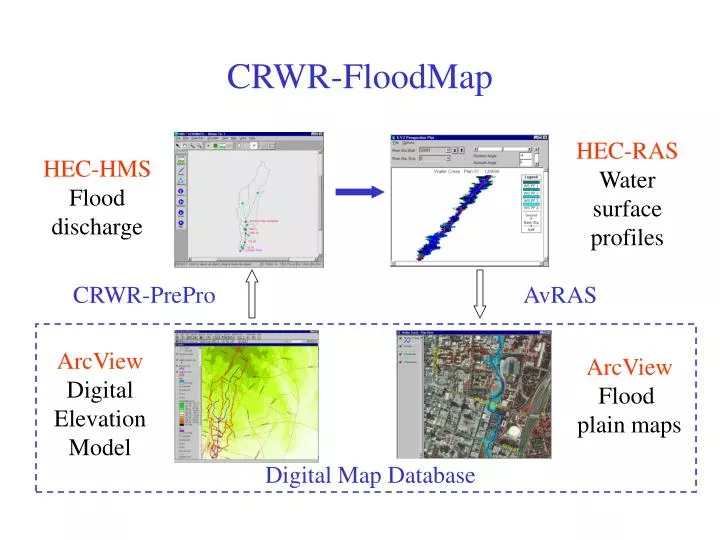
ArcView Digital Elevation Model. ArcView Flood plain maps. HEC-RAS Water surface profiles. HEC-HMS Flood discharge. CRWR-FloodMap. CRWR-PrePro. AvRAS. Digital Map Database. Waller Creek DEM. Waller Creek HMS Model. Flood Plain Mapping. HEC-RAS: Background.

E N D
ArcView Digital Elevation Model ArcView Flood plain maps HEC-RAS Water surface profiles HEC-HMS Flood discharge CRWR-FloodMap CRWR-PrePro AvRAS Digital Map Database
HEC-RAS: Background • River Analysis System model of the U.S. Army Corps of Engineers • Input = cross-section geometry and flow rates • Output = flood water elevations Cross-Section Schematic
HEC-RAS: Cross-Section Description • Points describe channel and floodway geometry • Bank station locations • Water surface elevations and floodplain boundaries
3-Dimensional River Channel ProfileLine Each point has (x,y,z) coordinates CrossSectionLine
ArcView Digital Elevation Model ArcView Flood plain maps HEC-RAS Water surface profiles HEC-HMS Flood discharge CRWR-FloodMap CRWR-PrePro AvRAS Digital Map Database
HEC-RAS: Output Graphical Text File
HEC-RAS: Data Translation • Data translation from HEC-RAS text file to dbase table • Bank and floodplain boundaries measured from stream centerline
Digital Stream Mapping • Digital orthophotograph and road coverage used as a base map • User digitizes stream with mouse • Boundary points define the RAS stream
3D Terrain Modeling: Procedure Outside Channel: Raster Inside Channel: Vector Result: TIN
3D Terrain Modeling: Procedure DEM raster to vector conversion Form a cross-section bounding polygon Intersect DEM points with bounding polygonand delete selected points
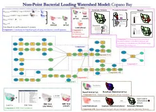
Real-time flood emergency mapping Nexrad radar rainfall input Real time Precomputed flood map library Offline Flood hydrology analysis system