Download
1 / 10
100 likes | 219 Views
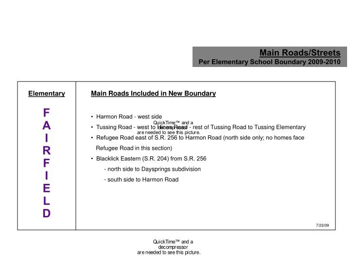
Main Roads/Streets Per Elementary School Boundary 2009-2010. Elementary F A I R F I E L D. Main Roads Included in New Boundary • Harmon Road - west side • Tussing Road - west to Hines Road - rest of Tussing Road to Tussing Elementary

E N D
Main Roads/Streets Per Elementary School Boundary 2009-2010 Elementary F A I R F I E L D Main Roads Included in New Boundary • Harmon Road - west side • Tussing Road - west to Hines Road - rest of Tussing Road to Tussing Elementary • Refugee Road east of S.R. 256 to Harmon Road (north side only; no homes face Refugee Road in this section) • Blacklick Eastern (S.R. 204) from S.R. 256 - north side to Daysprings subdivision - south side to Harmon Road 7/23/09
Main Roads/Streets Per Elementary School Boundary 2009-2010 Main Roads Included in New Boundary “Olde” Village Streets include: • Ashton Street • Borland Street • Center Street to Stemen Road • Church Street • Columbus Street East • Columbus Street West both sides to Long Road • Cross Street • East Street • Fancher Street • Hill Road North both sides from Meadowbrook directly across from Ridgeview Junior High to Courtright Drive Rural areas include: • Allen Road south of S.R. 256 • Busey Road - both sides, east of Amanda-Northern Road • Carroll-Northern Road - south of Rt. 256 • Columbus-Lancaster Road (Rt. 33) • Hill Road (see Village above) • Lockville Road-Pickerington Road South (aka County Rd. 20) • Reynoldsburg-Baltimore Road South (S.R. 256 East) through “olde” village both sides to Allen Road then just south side to district’s east boundary Elementary H E R I T A G E 7/23/09
Main Roads/Streets Per Elementary School Boundary 2009-2010 Elementary P I C K E R I N G T O N Main Roads Included in New Boundary • Bowen Road - to district’s south-west boundary • Columbus Street West, north side of road only, from Long Road to Diley Road (except those addresses part of Manor House subdivision) • Diley Road South to Wright Road • Long Road • School House Road • Wright Road - north side from Diley Road to School House Road, then both sides to district’s west boundary • Refugee Road - west of Hill Road North (S.R. 256) to district’s west boundary 7/23/09
Main Roads/Streets Per Elementary School Boundary 2009-2010 Elementary S Y C A M O R E Main Roads Included in New Boundary • Amanda-Northern Road - both sides • Diley Road - both sides south of Wright Road • Hill Road - both sides north to Meadowbrook subdivision across from Ridgeview Junior High • Busey Road, north side of road only, west from Hill Road to district’s west boundary • Columbus Street West - south side of road only, from Long Road to Diley Road C R E E K 7/23/09
Main Roads/Streets Per Elementary School Boundary 2009-2010 Elementary T O L L G A T E Main Roads Included in New Boundary • Allen Road - north of S.R. 256 • Ault Road • Bickel Church Road • Blacklick-Eastern Road (S.R. 204), north side of road only, east of Harmon Road, starting at the Daysprings subdivision • Carroll-Northern Road (north of Rt. 256 only) • Doty Road • Milnor Road - both sides from Pickerington Northern Road to Blacklick-Eastern Road (S.R. 204), except west side of road between Pickerington Northern Road and Refugee Road • Pickerington Northern Road north of Stemen Road to Blacklick-Eastern Road (S.R. 204) • Refugee Road both sides starting at west edge of Countrywood and continuing east to district’s boundary • Saylor Road • Stemen Road • Stoudertown Road • Toll Gate Road • Wagram Road 7/23/09
Main Roads/Streets Per Elementary School Boundary 2009-2010 Elementary T U S S I N G Main Roads Included in New Boundary • Tussing Road west of Hines Road • Hines Road (no homes face this road) 7/23/09
Main Roads/Streets Per Elementary School Boundary 2009-2010 Elementary V I O L E T Main Roads Included in New Boundary • Refugee Road south side going east from S.R. 256 to Milnor Road • Harmon Road east side • Blacklick-Eastern Road, south side of road only, from east edge of Ashley Creek subdivision to Harmon Road • Milnor Road, west side of road only, going north from Pickerington-Northern Road to Refugee Road 7/23/09
Main Roads/Streets Per Middle School Boundary 2009-2010 Middle School D I L E Y Main Roads Included in New Boundary • Allen Road both sides south of Busey Road • Amanda-Northern Road • Basil-Western Road • Bowen Road • Busey Road both sides • Carroll-Northern Road, south of Busey Road • Columbus-Lancaster Road • Diley Road • Hill Road South - both sides north to Opportunity Way then Hill Road North west side only to Mingo Estates • Long Road • Pickerington Road South - south of Busey Road to district’s south boundary • Refugee Road - west of Hill Road to district’s west boundary • Wright Road “Olde” Village • Columbus Street West (from Hill Road, west to Diley Road - then, Columbus Street West becomes Wright Road) • Hill Road North (see above) 7/23/09
Main Roads/Streets Per Middle School Boundary 2009-2010 Middle School H A R M O N Main Roads Included in New Boundary • Blacklick-Eastern Road East - S.R. 204 to Harmon Road and Haaf Farms • Harmon Road • Hines Road • Refugee Road east of Hill Road North (S.R. 256) both sides to Harmon Road - then north side ending at Mallard Pond subdivision 7/23/09
Main Roads/Streets Per Middle School Boundary 2009-2010 Main Roads Included in New Boundary • Ault Road • Bickel Church Road • Blacklick-Eastern Road (S.R. 204) east of Harmon Road starting at Daysprings subdivision • Carroll-Northern Road, north of Busey Road • Hill Road north of Opportunity Way east side to Mingo Estates • Lockville Road/Pickerington Road South (aka County Rd. 20) • Milnor Road north from Center Street (Pickerington-Northern Road) both sides to Blacklick-Eastern Road (S.R. 204) • Pickerington Road north of Busey through “olde” village to Blacklick-Eastern Road (S.R. 204) • Refugee Road east of Harmon Road south side to Milnor Road then both sides to district’s east boundary • Reynoldsburg-Baltimore Road, east out of Olde Pickerington Village to district’s east boundary • Saylor Road • Stemen Road • Stoudertown Road • Toll Gate Road • Wagram Road “Olde” Village • Borland Street • Cross Street • Center Street • East Street • Church Street • Fancher Street • Columbus Street East • Columbus Street West (east from Hill Road to Center Street) Middle School T O L L G A T E 7/23/09