Download
1 / 62
620 likes | 628 Views
LEQ: What is the oldest, continuously occupied city in what is now the United States?.

E N D
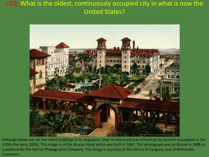
LEQ:What is the oldest, continuously occupied city in what is now the United States? Although these are not the oldest buildings in St. Augustine, their architectural was influenced by Spanish occupation in the 1500s-the early 1800s. This image is of the Alcazar Hotel which was built in 1887. This photograph was produced in 1898 as a postcard for the Detroit Photographic Company. This image is courtesy of the Library of Congress and of Wikimedia Commons.
LEQ:What is the oldest, continuously occupied city in what is now the United States?St. Augustine, Florida Although these are not the oldest buildings in St. Augustine, their architectural was influenced by Spanish occupation in the 1500s-the early 1800s. This image is of the Alcazar Hotel which was built in 1887. This photograph was produced in 1898 as a postcard for the Detroit Photographic Company. This image is courtesy of the Library of Congress and of Wikimedia Commons.
Spain’s New World Empire Basics During the Spanish colonization of the Americas, the Cross of Burgundy served as the flag of the Viceroyalty of New Spain, and Peru at sea, and in forts. Another flag, the Royal Standard of Spain, was used for all other purposes. This image is courtesy of Wikimedia Commons.
Spain’s New World EmpireVocabulary This image is from wordinfo.info.
A Spanish or Portuguese adventurer or conqueror of “new” lands. This image is titled The Conquistadors Entered Tenochtitlan to the Sounds of Martial Music. This image was created by Margaret Duncan Coxhead in 1909 for the Romance of History, Mexico. This image is courtesy of Wikimedia Commons.
ConquistadorA Spanish or Portuguese adventurer or conqueror of “new” lands. This image is titled The Conquistadors Entered Tenochtitlan to the Sounds of Martial Music. This image was created by Margaret Duncan Coxhead in 1909 for the Romance of History, Mexico. This image is courtesy of Wikimedia Commons.
Conquistadors sailed from Europe to the Americas, Africa, and Asia, conquering territory and opening trade routes. This image shows Diego de Almagro leading the first Spanish expedition into Chile. This event occurred from 1535-1537. This image was painted by Pedro Subercaseaux (1880-1956) in the early 1900s. This image is courtesy of Wikimedia Commons.
A small highly maneuverable sailing ship developed by the Portuguese that enabled them to sail from Europe to Asia. A caravel had lateen triangular sails. A lateen sail was suspended at a slanted angle from a mast. These sails gave her speed and an easier method of changing direction than square sails used by most ships at the beginning of the 1400s. This image was photographed at the Marine Museum in Paris, France, and is courtesy of Wikimedia Commons.
CaravelA small highly maneuverable sailing ship developed by the Portuguese that enabled them to sail from Europe to Asia. A caravel had lateen triangular sails. A lateen sail was suspended at a slanted angle from a mast. These sails gave her speed and an easier method of changing direction than square sails used by most ships at the beginning of the 1400s. This image was photographed at the Marine Museum in Paris, France, and is courtesy of Wikimedia Commons.
The caravels brought large amounts of wealth to Portugal from Asia because traveling by water was faster than traveling by land. This photograph is of a replica of the Flor de la Mar, a Portuguese carrack of 400 tons. For nine years she participated in decisive events in the Indian Ocean until she was sunk in 1511. It was returning from sacking Malacca, Malaysia with a huge amount of treasure for the Portuguese King when it sank off the coast of Sumatra. This replica is at the Maritime Museum in Malacca. This image, taken by Felix Andrews on January 27, 2006 is courtesy of Wikimedia Commons.
A sailing ship, usually with three or four masts, developed in the 1400s in Genoa Italy for commerce and ocean-going travel. Columbus’ ships, the Santa Maria and the Pinta were carracks. The Nina (left) was a caravel. This image, titled Columbus’ Ships, was created by Gustav Adolf Closs (1864-1938) in 1892. This image is courtesy of Wikimedia Commons.
CarrackA sailing ship, usually with three or four masts, developed in the 1400s in Genoa Italy for commerce and ocean-going travel. Columbus’ ships, the Santa Maria and the Pinta were carracks. The Nina (left) was a caravel. This image, titled Columbus’ Ships, was created by Gustav Adolf Closs (1864-1938) in 1892. This image is courtesy of Wikimedia Commons.
Carracks were large enough to be stable in heavy seas, and roomy enough to carry food and supplies for long voyages. This image shows a model of the carrack Madre de Deus in the Maritime Museum in Lisbon, Portugal. When she was built in 1589 she had seven decks, and was the largest ship in the world. This photograph was taken by Marco2000 in 2009. This image is courtesy of Wikimedia Commons.
A large, multi-decked ocean going, sailing ship which evolved from the carrack in the 1500s. This image shows a Spanish galleon (left) firing its cannon into a Dutch warship (right). This image was painted by Cornelis Verbeeck (circa 1590-after 1637) circa 1619. This image is courtesy of the National Gallery of Art and of Wikimedia Commons.
GalleonA large, multi-decked ocean going, sailing ship which evolved from the carrack in the 1500s. This image shows a Spanish galleon (left) firing its cannon into a Dutch warship (right). This image was painted by Cornelis Verbeeck (circa 1590-after 1637) circa 1619. This image is courtesy of the National Gallery of Art and of Wikimedia Commons.
Galleons were longer, lower, and narrower than carracks. Galleons weighed around 500 tons, and carracks usually weighed 1000 tons. Galleons were faster and more maneuverable than carracks. This image shows two carracks on the left and a galleon on the right. This is a detail of an image created by D. Joao de Castro titled Suez Expedition” in 1541. This image is courtesy of Wikimedia Commons.
Spain’s New World EmpirePeople to Meet Francisco Coronado (1510-1554) was a Spanish explorer who visited New Mexico and other parts of what are now the southwestern United States between 1540-1542. This painting by Frederic Remington (1861-1909) is titled Coronado Sets Out to the North. This image is courtesy of Wikimedia Commons.
Native group whom dominated the region of Central Mexico from approximately the 1300s-1500s. This drawing shows Aztecs storing maize or corn. This is an illustration from the Florentine Codex which was created in the late 1500s. This image is courtesy of Wikimedia Commons.
AztecsNative group whom dominated the region of Central Mexico from approximately the 1300s-1500s. This drawing shows Aztecs storing maize or corn. This is an illustration from the Florentine Codex which was created in the late 1500s. This image is courtesy of Wikimedia Commons.
Native group whose empire in the region of Peru and the Pacific Coast of South America was the largest in area before the Spanish invaded. This photograph shows Machu Picchu, which is a World Heritage Site located near Cusco, Peru. It was built as an estate for an Incan emperor. This image was taken by Martin St.-Amant in 2009. This image is courtesy of Wikimedia Commons.
IncasNative group whose empire in the region of Peru and the Pacific Coast of South America was the largest in area before the Spanish invaded. This photograph shows Machu Picchu, which is a World Heritage Site located near Cusco, Peru. It was built as an estate for an Incan emperor. This image was taken by Martin St.-Amant in 2009. This image is courtesy of Wikimedia Commons.
A Spanish Conquistador who led an expedition that caused the fall of the Aztec Empire and conquered large sections of Mexico for Spain. Hernan Cortes (1485-1547) was born in Medellin Spain to a family that was not very high on the rankings of nobility. This image, painted circa the early 1500s is courtesy of the Museum of the Americas and of Wikimedia Commons.
Hernan CortesA Spanish Conquistador who led an expedition that caused the fall of the Aztec Empire and conquered large sections of Mexico for Spain. Hernan Cortes (1485-1547) was born in Medellin Spain to a family that was not very high on the rankings of nobility. This image, painted circa the early 1500s is courtesy of the Museum of the Americas and of Wikimedia Commons.
A Spanish Conquistador who led an expedition that caused the fall of the Inca Empire and conquered large sections of South America for Spain. Francisco Pizarro (circa 1473-1541) was born in Trujillo Spain and was a distant cousin of Hernan Cortes. This image is courtesy of Wikimedia Commons.
Francisco PizarroA Spanish Conquistador who led an expedition that caused the fall of the Inca Empire and conquered large sections of South America for Spain. Francisco Pizarro (circa 1473-1541) was born in Trujillo Spain and was a distant cousin of Hernan Cortes. This image is courtesy of Wikimedia Commons.
A Portuguese explorer, sailing for Spain, who organized the first expedition to circumnavigate the globe. Ferdinand Magellan (circa 1480-1521) did not finish the journey around the world. He was killed by natives in the Philippines towards the end of the voyage. This image was created by an unknown artist circa 1600. This image is courtesy of the Mariner’s Museum Collection of Newport News, Virginia, and of Wikimedia Commons.
Ferdinand MagellanA Portuguese explorer, sailing for Spain, who organized the first expedition to circumnavigate the globe. Ferdinand Magellan (circa 1480-1521) did not finish the journey around the world. He was killed by natives in the Philippines towards the end of the voyage. This image was created by an unknown artist circa 1600. This image is courtesy of the Mariner’s Museum Collection of Newport News, Virginia, and of Wikimedia Commons.
A Spanish Conquistador, explorer, and governor who was the first European to lead an expedition from the “New World” to the Pacific Ocean. Vasco Nunez de Balboa (circa 1475-1519) did not finish the journey around the world. He was killed by natives in the Philippines towards the end of the voyage. This image was created by Frederick A. Ober in 1906. This image first appeared in Ober’s work: Vasco Nunez de Balboa, which was published in Ne Yard by Harpers Publishing in 1906. This image is courtesy of Wikimedia Commons.
Vasco Nunez de BalboaA Spanish Conquistador, explorer, and governor who was the first European to lead an expedition from the “New World” to the Pacific Ocean. Vasco Nunez de Balboa (circa 1475-1519) did not finish the journey around the world. He was killed by natives in the Philippines towards the end of the voyage. This image was created by Frederick A. Ober in 1906. This image first appeared in Ober’s work: Vasco Nunez de Balboa, which was published in Ne Yard by Harpers Publishing in 1906. This image is courtesy of Wikimedia Commons.
A Spanish explorer and Conquistador, who led the first European expedition to Florida, and gave Florida its name. Juan Ponce de Leon (circa 1474-1521) may or may not have been searching for a “Fountain of Youth” on his expedition to Florida. No mention of a Fountain of Youth was made in Spanish writings until after his death. This image first appeared in Appletons’ Cyclopaedia of American Biography, volume 5, p. 61, which was published in 1900. This image is courtesy of Wikimedia Commons.
Juan Ponce de LeonA Spanish explorer and Conquistador, who led the first European expedition to Florida, and gave Florida its name. Juan Ponce de Leon (circa 1474-1521) may or may not have been searching for a “Fountain of Youth” on his expedition to Florida. No mention of a Fountain of Youth was made in Spanish writings until after his death. This image first appeared in Appletons’ Cyclopaedia of American Biography, volume 5, p. 61, which was published in 1900. This image is courtesy of Wikimedia Commons.
A Spanish explorer and Conquistador, who led the first European expedition from Mexico into the southwestern United States. Francisco Vasquez de Coronado (circa 1510-1554) was searching for the mythical Seven Cities of Gold. This image is on display at the Deaf Smith Historical Museum in Hereford, Texas. This image is courtesy of Wikimedia Commons.
Francisco Vasquez de CoronadoA Spanish explorer and Conquistador, who led the first European expedition from Mexico into the southwestern United States. Francisco Vasquez de Coronado (circa 1510-1554) was searching for the mythical Seven Cities of Gold. This image is on display at the Deaf Smith Historical Museum in Hereford, Texas. This image is courtesy of Wikimedia Commons.
A Spanish explorer and Conquistador, who led the first European expedition from Florida into the southeastern United States. Hernando de Soto (1496-1542) was also the first European to cross the Mississippi River. This image was created by John Sartain (1808-1897) for Lambert A. Wilmer’s The Life, Travels, and Adventures of Ferdinand De Soto. This image is courtesy of Wikimedia Commons.
Hernando De SotoA Spanish explorer and Conquistador, who led the first European expedition from Florida into the southeastern United States. Hernando de Soto (1496-1542) was also the first European to cross the Mississippi River. This image was created by John Sartain (1808-1897) for Lambert A. Wilmer’s The Life, Travels, and Adventures of Ferdinand De Soto. This image is courtesy of Wikimedia Commons.
Spain’s New World EmpireMaps This map shows the first circumnavigation of the globe by an expedition organized by Ferdinand Magellan. This image is courtesy of Wikimedia Commons.
EuropeFind the continent of Europe on the map showing the countries of the world. This map shows many of the countries of the world. This map was made by Petr Dlouhy. The image is courtesy of Wikimedia Commons.
EuropeFind the continent of Europe on the map showing the countries of the world. Europe is now colored red. This map shows many of the countries of the world. This map was made by Petr Dlouhy. The image is courtesy of Wikimedia Commons.
SpainFind the country of Spain on the map showing the countries of the world. This map shows many of the countries of the world. This map was made by Petr Dlouhy. The image is courtesy of Wikimedia Commons.
SpainFind the country of Spain on the map showing the countries of the world. Spain is now colored red. This map shows many of the countries of the world. This map was made by Petr Dlouhy. The image is courtesy of Wikimedia Commons.
North AmericaFind the continent of North America on the map showing the continents of the world. This map shows the seven continents. The image is courtesy of vecteezy.com.
North AmericaFind the continent of North America on the map showing the continents of the world. North America is now colored red. This map shows the seven continents. The image is courtesy of vecteezy.com.
MexicoFind Mexico on this map of North America. This is a political map of North America. The image is courtesy zonu.com.
MexicoFind Mexico on this map of North America. Mexico is now colored red. This is a political map of North America. The image is courtesy of zonu.com.
ArizonaFind Arizona on this map of the 50 States of the United States. This image shows the 50 States of the United States. This image is courtesy of the University of Texas.
ArizonaFind Arizona on this map of the 50 States of the United States. Arizona is now colored red. On February 14, 1912, Arizona became the 48th State. This image shows the 50 States of the United States. This image is courtesy of the University of Texas.
Grand CanyonFind the Grand Canyon on this map of the 50 States of the United States. This image shows the 50 States of the United States. This image is courtesy of the University of Texas.
Grand CanyonFind the Grand Canyon on this map of the 50 States of the United States. The Grand Canyon’s location is marked by a red dot and the words “Grand Canyon.” This image shows the 50 States of the United States. This image is courtesy of the University of Texas.
FloridaFind Florida on this map of the 50 States of the United States. This image shows the 50 States of the United States. This image is courtesy of the University of Texas.
FloridaFind Florida on this map of the 50 States of the United States. Florida is now colored red. This image shows the 50 States of the United States. This image is courtesy of the University of Texas.