Download
1 / 10
100 likes | 182 Views
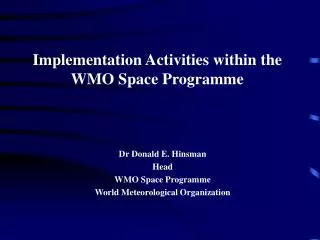
Progress Report on Sustained Co-Ordinated Processing of Environmental Satellite Data for Climate Monitoring (SCOPE-CM). CM-11, Item 5. Barbara J. Ryan Director, WMO Space Programme. End-to-End System. Consistent Calibrated data sets. Sustained QC products. Satellite data.

E N D
Progress Report on Sustained Co-Ordinated Processing of Environmental Satellite Data for Climate Monitoring (SCOPE-CM) CM-11, Item 5 Barbara J. Ryan Director, WMO Space Programme
End-to-End System ConsistentCalibrateddata sets Sustained QC products Satellite data Satellites & sensors Wider access Users GSICS GOS/WIGOS SCOPE-CM IGDDS/WIS • Space-based Architecture for Weather and Climate Monitoring • Global Space-based Inter-calibration System (GSICS) • Sustained Co-Ordinated Processing of Environmental satellite data for Climate Monitoring (SCOPE-CM) • Data/Product Dissemination Strategy (IGDDS/WIS)
GCOS Essential Climate Variables (ECVs) • Oceans • O.1 Sea Ice • O.2 Sea Level • O.3 Sea Surface Temperature • O.4 Ocean Colour • O.5 Sea State • O.6 Ocean Reanalysis • O.7 Ocean Salinity • Atmosphere A.1 Surface Wind Speed and Direction A.2 Upper-air Temperature A.3 Water A Vapour A.4 Cloud properties A.5 Precipitation A.6 Earth Radiation Budget A.7 Ozone A.8 Atmospheric reanalysis (multiple ECVs) A.9 Aerosols A.10 Carbon Dioxide, Methane and other Greenhouse Gases A.11 Upper-air Wind • Terrestrial • T.1 Lakes • T.2 Glaciers and Ice Caps, and Ice Sheets • T.3 Snow Cover • T.4 Albedo • T.5 Land Cover • T.6 fAPAR • T.7 LAI • T.8 Biomass • T.9 Fire Disturbance • T.10 Soil Moisture
SCOPE-CM Participants • Satellite Operators: • EUMETSAT • NOAA • JMA • CMA • Stakeholders • GCOS • CGMS/GSICS • CEOS • GEO • WCRP
SCOPE-CM Phases Phase I Phase II Phase III • full deployment of the sustained system of product generation • product review and quality control • continuous product improvement 2008 2009 2010 2011 2012 2013 2014 •establishment of structures for sustainable generation of FCDRs and TCDRs • generation of first SCOPE-CM products • increased coverage of products in terms of ECVs, time and spatial dimension • fostering extension of the network establish initial network and structure agreement on principles and standards first pilot projects on selected subjects assessment of current capabilities establishment of feedback mechanisms
Pilot Project 2 SSM/I 20-year data set of water vapour over ocean MPI-Meteorology University Hamburg Research To Operations
Pilot Project 4 • Clear Sky Radiance from JMA Geostationary satellites 15-year Clear Sky Radiance data set from 1995 to 2009 2009 CSR from GMS-5 22 Jan 1999 CSR from MTSAT-1R 22 Jan 2009
CM-11 is Invited to: • Note the progress of the SCOPE-CM process • Support the ongoing pilot project efforts • Provide feedback and guidance as appropriate