Download
1 / 41
410 likes | 537 Views
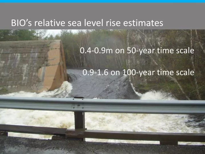
BIO’s relative sea level rise estimates. 0.4-0.9m on 50-year time scale 0.9-1.6 on 100-year time scale. Example from County of Colchester / Truro . MSC’s STORM SURGE MODEL Tell us the impacts you are seeing and at what water levels! Model based on OUTPUT WINDS. MSC’s STORM SURGE MODEL

E N D
BIO’s relative sea level rise estimates 0.4-0.9m on 50-year time scale 0.9-1.6 on 100-year time scale
Example from County of Colchester / Truro
MSC’s STORM SURGE MODEL Tell us the impacts you are seeing and at what water levels! Model based on OUTPUT WINDS
MSC’s STORM SURGE MODEL Map display; every hour for 48 hrs out from when model run Time series graph; point forecast for specific location. Show stage 1, 2 or 3 flooding based on past events.
MSC’s STORM SURGE MODEL Does NOT include wave run up Add 10% to surge levels if wind facing shoreline . . . . . . then add tide level
MSC’s STORM SURGE MODEL 65cm surge predicted at nearly high tide = 2.9m 75-80 cm surge experienced = so 3m + at least another 10cm for wave run up (more if wind from S/SE)
Geohazards? What’s the short-list of geohazards potentially relevant to my MCCAP? How are they relevant, and are they priorities? • THANK YOU! • Garth DeMont, Geoscientist with NS Department of Natural Resources • Gavin Kennedy, Hydrogeologist with NS Department of Natural Resources • John Drage, Hydrogeologist with NS Department of Natural Resources
Assessing Geological Hazards Geo-events that pose threats 4 of 30 • coastal flooding & riverine flooding • coastal erosion • land sinking – sinkholes • contamination of water from heavy metals in soil or acid rock drainage • landslides / slope failure . . . to develop a methodology to incorporate geology into the land use planning process Picture from NS DNR Geological Services Division
Assessing Geological Hazards Geohazard—Coastal erosion 4 of 30 The need to establish setbacks should be informed by geology – both bedrock and surficial . . . to develop a methodology to incorporate geology into the land use planning process Coastal erosion risk will increase with sea level rise. Picture from NS DNR Geological Services Division Picture from NS DNR Geological Services Division
Assessing Geological Hazards Geohazard—Karst 4 of 30 • Occurs in • limestone & gypsum • sinkholes • water contamination . . . to develop a methodology to incorporate geology into the land use planning process Under the Nova Scotia Treatment Standard for Municipal Surface Source Water Treatment Facilities, once designated, karst areas are subject to water treatment standards. Picture from NS DNR Geological Services Division Picture from NS DNR Geological Services Division
Assessing changes in precipitation . . . to develop a methodology to incorporate geology into the land use planning process
Assessing changes in precipitation . . . to develop a methodology to incorporate geology into the land use planning process
Assessing changes in precipitation Update the Draft Stormwater Management Plan Recommend BMPs so that future development won’t increase peak runoff flows . . . to develop a methodology to incorporate geology into the land use planning process
Assessing changes in precipitation Update the Draft Stormwater Management Plan Recommend BMPs so that future development won’t increase peak runoff flows Assess the effects of climate change on rainfall intensity and the effects of these changes on the storm water mgt plan
SWMM5 Stormnet
Assessing changes in precipitation New climate-wise design rainfalls Stormnet
Assessing changes in precipitation What’s the rainfall pattern during the day: sub-day durations? (used for IDF curves)
Assessing changes in precipitation • Conclusions: • Predicted magnitude of the increase in precip volume expected in 1 day is 29% • Predicted increases for 24 hr rain are higher than increases in annual rainfall • Predicted increases for shorter durations are greater than increases for longer durations . . . to develop a methodology to incorporate geology into the land use planning process
Assessing changes in precipitation Stormnet Design Storms
Assessing changes in precipitation • redefine peak flows to be associated with potential future rainfall events • estimate the equivalent pipe diameter of culverts required to convey the peak flows, and • estimate the costs for culvert replacements to accommodate peak flows
Assessing changes in precipitation Minor Drainage System
Assessing changes in precipitation Designed for rainfall events with return periods of 1 in 5 to 1 in 10 , based on HISTORICAL RECORD.
Assessing changes in precipitation Designed for rainfall events with return periods of 1 in 5 to 1 in 10 , based on HISTORICAL RECORD. Rainfall events in exceeding this cause surcharge: Up-the-pipe-flooding
Assessing changes in precipitation Major Drainage System Natural water channels tend to have capacity for a 1 in 2 year rainfall event, based on historical records
Assessing changes in precipitation Major Drainage System The level of service expected by the public and other stakeholders is rising
Assessing changes in precipitation Recommendation: All structures with capacity less than the estimated maximum peak runoff flows predicted by the (stormnet) modeling should be upgraded.
Assessing changes in precipitation Major Drainage System • 4 Recommendations: • Examine each watershed in the Town, starting with the watershed where the potential risk of flood damage is greatest, and figure out: • if and where there are opportunities to increase the capacity for water storage/detention and • if existing culverts and structures could withstand a 1 in 100 year return period rainfall as defined by simulated rainfall events modeled in the study.
Assessing changes in precipitation Major Drainage System • 4 Recommendations: • 2. Identify flood limits generated by the design rainfall event with 1 in 100 year return period on Town Land Use Mapping
Assessing changes in precipitation Major Drainage System • 4 Recommendations: • 3. DEFINE acceptable level of (stormwater mgt) service in consultation with stakeholders
Assessing changes in precipitation Major Drainage System • 4 Recommendations: • 4. Develop a prioritized list of modifications to existing structures (e.g. culverts), based on what they now knew about the condition and capacity of existing culverts, as well as stakeholder views on acceptable levels of flood risk
Assessing changes in precipitation . . . to develop a methodology to incorporate geology into the land use planning process Plan to adopt the updated Plan at the Jan. 2013 Council mtg
Assessing changes in precipitation . . . to develop a methodology to incorporate geology into the land use planning process A stormwater mgt plan will have to be submitted as part of all development applications
Assessing changes in precipitation • Take away messages: • Work at the watershed level • Engage climatologists to model and downscale design rainfalls • Ask about the modeling software • Visually present flood hazard and risk to stakeholders . . . to develop a methodology to incorporate geology into the land use planning process
Assessing changes in precipitation • Take away messages continued: • Gauge stakeholder risk tolerance • A lower level of service is inevitable • Development controls crucial to SWMM • Again…make sure stakeholders understand the risks . . . to develop a methodology to incorporate geology into the land use planning process
Anne Warburton awarburton@elementalsustainability.com 902 431 7168 www.elementalsustainability.ca