Download
1 / 13
130 likes | 192 Views
ERAU ASCEND! OverView. Adam Ritchie Nicholas Hammons Andrew Grant Geimi Delarge. Overview. Flight Objectives Payload Flights Taken Conclusions Future Goals. Flight Objectives. Gain better knowledge of the nature of composite materials Gather temperature data along the flight

E N D
ERAU ASCEND!OverView Adam Ritchie Nicholas Hammons Andrew Grant GeimiDelarge
Overview • Flight Objectives • Payload • Flights Taken • Conclusions • Future Goals
Flight Objectives • Gain better knowledge of the nature of composite materials • Gather temperature data along the flight • Gather IMU data • Gather pressure data along the flight • Gather solar cell data along the flight • Track and recover payload
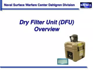
Payload • 8 Inch Composite Cube • Bi-directional Carbon with ¼” foam core • E-glass shelving system and lid • Automatic Position Reporting System (APRS) • Lassen IQ GPS • TTY TinyTrak4 TNC • Alinco radio • Logomatic Data Logger
Payload (continued) • First Flight Only • Sparkfun 6 DOF IMU • HOBO Datalogger • Second Flight Only • Invensys Pressure Sensor • Dallas One Wire Thermistors • Two Solar Cells • 28-X1 Picaxe Microcontroller
Flight #1: Nov. 22, 2008 • Launched from Gila Bend • Traveled 61.1 statute miles • Flight time: 2:02:32 • Peak Altitude: 95,867 ft. • Landed south of Chandler Source: kd7lmo.net
Flight #1 (continued) • HOBO datalogger recorded temperature and relative humidity • IMU data was retrieved but could not be analyzed • GPS tracking was successful up to burst and then during part of the descent Source: kd7lmo.net
Flight #2: April 4, 2009 • Launched from Gila Bend • Traveled 81.4 statute miles • Flight time: 1:57:05 • Peak Altitude: 89,676 ft. • Landed East of Florence
Flight #2 (continued) • Temperature, pressure, and solar cell data successfully recorded • GPS never acquired satellites due to antenna installation Source: kd7lmo.net
Conclusions • Two successful launches • Recovered payload after both launches • Gathered temperature, pressure, and IMU data • Cannot put aluminum tape over GPS antenna • Created own systems instead of using heavy, off the shelf systems • Improved structural layout to improve wiring layout
Future Goals • Reduce weight • Improve wiring by integrating PCB • Make GPS more reliable • Integrate solar cells to power the payload Questions?
Thank You! • Dr. Ron Madler • Jack Crabtree • Dr. John Nafziger • Chris Smith • ANSR • Susan Brew
Structures and System Integration Nicholas Hammons