Download
1 / 27
270 likes | 557 Views
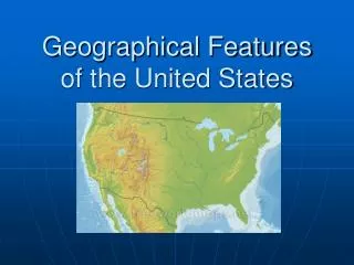
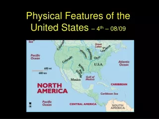
Important physical and man-made features in the United States. The Atlantic Coastal Plain. The Atlantic Coastal Plain is the flat stretch of land that borders the Atlantic Ocean (including the Gulf of Mexico).

E N D
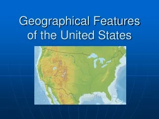
Important physical and man-made features in the United States.
The Atlantic Coastal Plain • The Atlantic Coastal Plain is the flat stretch of land that borders the Atlantic Ocean (including the Gulf of Mexico). • It is approximately 2,200 miles long, stretching from Cape Cod, through the southeast United States and through Mexico, ending with the Yucatán Peninsula. • The western border of the coastal plain is defined as the fall line, to the west of which lies the Piedmont Plateau and then the Appalachian Mountains.
Cont… • The Atlantic Coastal Plain in the U.S. • Currently, the coastal plain is very wet, including many rivers, marsh, and swampland. It is primarily used for agriculture.
Great Plains • The Great Plains is the broad expanse of prairie and steppe which lies east of the Rocky Mountains in the United States and Canada. • This area covers parts of the U.S. states of Colorado, Kansas, Montana, Nebraska, New Mexico, North Dakota, Oklahoma, South Dakota, Texas and Wyoming, and the Canadian provinces of Alberta, Manitoba and Saskatchewan.
North America has four continental divides which divides separate waters that flow to different oceans • The Great Divide • The Northern Divide • The St. Lawrence Seaway Divide • The Eastern Continental Divide
The Great divide Is a drainage that separates the watersheds of the Pacific Ocean from those of the Atlantic and Arctic Oceans. This Continental Divide of the U.S. begins at Cape Prince of Wales, Alaska. It crosses into the United States in northwestern Montana. Divide crosses into Wyomingat Yellowstone National Park and continues south-southeast into Colorado, then western New Mexico. It is crossed by the Panama Canal.
The Great Basin The Great Basin is a large, arid region of the western United States. Its boundaries depend on how it is defined. Its most common definition is the contiguous watershed, roughly between the Rocky Mountains and the Sierra Nevada, that has no natural outlet to the sea.
Death Valley Death Valley is a valley in the state of California, and is the location of the lowest elevation in North America. Located southeast of the Sierra Nevada range in the Great Basin and the Mojave Desert, it comprises much of Death Valley National Park. It has an area of about 3,000 square miles • Temperatures in the Valley can range from up to 130 degrees in the day in the summer, to below freezing at night in the winter. • Many of Death Valley's narrow, winding roads were built in the 1930s and cannot be driven at high speed.
Gulf of Mexico • The Gulf of Mexico is the ninth largest body of water in the world. • It is an ocean basin largely surrounded by the North American continent and the island of Cuba. • It connects with the Atlantic Ocean through the Florida Straits between the U.S. and Cuba, and with the Caribbean Sea • It comprises the coasts states of Texas, Louisiana, Mississippi, Alabama, and Florida.
St. Lawrence River The Saint Lawrence River is a large west-to-east flowing river in the middle latitudes of North America, connecting the Great Lakes with the Atlantic Ocean. The Saint Lawrence begins at Lake Ontario and joins with the Atlantic Ocean in the Gulf of Saint Lawrence.
The Great Lakes A collection of freshwater seas located in eastern North America, on the Canada-United States border. Consisting of Lakes Superior, Michigan, Huron, Erie, and Ontario. HOMES: Huron, Ontario, Michigan, Erie, Superior They form the largest group of freshwater lakes on Earth.
New York City, NY Is the most populous city in the United States of America. Its business, financial and trading organizations are significant players in the nation's economy and in the world. The city is also one of the world's most important cultural centers with hundreds of world-class museums, galleries, and performance venues. Home of the United Nations, the city is also perhaps the world's largest diplomatic center. The "Big Apple", as the city is often called is located on that arm of the U.S. that sticks out on the Northeast side. New York is the state that looks like a large misshapen triangle. New York is located north of Pennsylvania; southwest of Vermont; west of Massachusetts and northwest of Connecticut.
New York City • The city is divided up into five boroughs (The Bronx, Brooklyn, Manhattan, Queens, and Staten Island) • The New York metropolitan area is one of the largest urban areas in the world.
The Statue of Liberty The statue stands on Liberty Island in New York Harbor . It is a World Heritage Site that has greeted millions of immigrants.
Empire State Building • The Empire State Building is a 102-story landmark Art Deco skyscraper in New York City. • When the Empire State Building opened on May 1, 1931, it was the tallest building in the world - standing at 1,250 feet tall. This building not only became an icon of New York City, it became a symbol of twentieth century man's attempts to achieve the impossible.
Boston, MA • Boston is the capital and most populous city of the Commonwealth of Massachusetts. • It is the largest city in New England. • Founded in 1630, it is the largest city in New England. Boston was the location of several major events during the American Revolution, and was a major shipping port and manufacturing center. • Today, the city is a center of higher education and health care. • It is located Massachusetts.
Philadelphia, PA • The city of Philadelphia is the largest city in Pennsylvania, the fifth most populous city in the United States. It is referred to as Philly, and known as The City of Brotherly Love. • It was the social and geographical center of the original 13 American colonies. • The city hosted the First Continental Congress before the war; the Second Continental Congress, which signed the United States Declaration of Independence, during the war; and the Constructional Convention after the war. • Several battles were fought in and near Philadelphia as well. • Philadelphia is a city located in the state of Pennsylvania. On the north eastern side of the United States of America.
Philadelphia, PA cont… • Eclipsed Boston and New York City in political and social importance, with Benjamin Franklin taking a large role in Philadelphia's rise. • The city was the geographic center of the 18th century thinking and activity that gave birth to the American Revolution and subsequent American democracy and independence
Erie Canal It is currently part of the New York State Canal System and runs from the Hudson River to Lake Erie, connecting the Great Lakes with the Atlantic Ocean. It connects New York City with the Great Lakes via the Hudson River. The Erie Canal was the first transportation route faster than carts pulled by draft animals between the Eastern Seaboard of the United States and the western interior, and cut transport costs into what was then wilderness by about 95%. The Canal resulted in a massive population surge in western New York, and opened regions further west to increase settlements.
Quiz • Where is the Atlantic Coastal Plain located? • Where is the Great Plains located? • What is the Continental Divide? • Where is the Great Basin located? • Where is Death Valley located? • Where is the Gulf of Mexico located? • Where is the St. Lawrence River located? • Where are the Great Lakes located? • Where is New York City , NY located? • Where is Boston, MA located? • Where is Philadelphia, PA located? • Where is and the Erie Canal located?
Assignment You may work in groups of 4 to create individual brochures. A brochure is small booklet of information. How many of you have made a brochure in the past? Your brochure must include: • Name of feature • Type of feature • Locations of feature • Map of feature
How to Make a Double Brochure A double parallel brochure is made by folding a page in half and then folding each folded page in half again in the same direction. After folding it consists of eight panels, four on the front and four on the back. The last two panels need to be slightly narrower than the outer panels so that they fit inside when folded. Visual: http://www.48hourprint.com/brochure-folding-guide.html
Now you may begin working with people in your group. You many use computers (time limit will be on computers), encyclopedias, almanacs, and text books. Do your best and Have fun!
List of Features • Atlantic Coastal Plain • Great Plains • Continental Divide • Great Basin • Death Valley • Gulf of Mexico • St. Lawrence River • Great Lakes • New York City , NY • Boston, MA • Philadelphia, PA • Erie Canal