Download

1 / 47
470 likes | 471 Views
This article examines several devastating landslides in developing nations in Latin America, including Ecuador, El Salvador, Nicaragua, and Venezuela. The causes, impacts, and consequences of these landslides are discussed in detail.

E N D
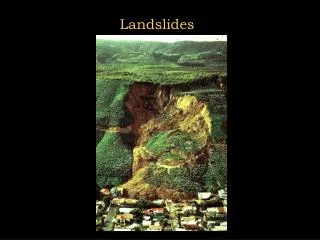
Landslides in Developing Nations Latin America
Near Quito, Ecuador • Date: March 11, 2004 • Type of mass wasting: Landslide • Cause: unknown • Result: rupture of the Transecuadorean Pipeline (14th major spill since 1998) • Oil is Ecuador’s leading export & second largest source of government income.
Santa Tecla, El Salvador • Date: January 2001 • Type of mass wasting: Landslide/earthflow • Cause: 13 Jan., 2001, El Salvador Earthquake (M=7.6) • Result: numerous landslides in volcanic rocks, PanAmerican Highway closed in two places • 265 - 450 people reported dead
Santa Tecla, El Salvado • Problem: battle between real-estate developers versus city officials, environmentalists and local residents • Claimed area was over-developed • “inherently geologically unstable” – local geologist • deforestation
Oblique aerial view of landslide that buried Colonia Las Colinas (Photograph by Edwin L. Harp, U.S. Geological Survey )
The Jan. 13 earthquake that hit El Salvador triggered this landslide from the Balsamo Ridge over Las Colinas. Edwin Harp (http://www.geotimes.org/mar01/geophen.html)
View of headscarp of Las Colinas landslide showing fractures in Balsamo ridge behind the scarp. Note the white tephra at the base of the steepest part of the headscarp. (Photograph by Edwin L. Harp, U.S. Geological Survey )
Nicaragua • Date: October 1988 • Type of mass wasting: Lahar • Cause: Hurricane Mitch • Stalled off the Honduras & Nicaragua coast • 25-75” of rain fell over three days • Result: 2000 killed when a crater lake overflowed and created a lahar
Cerro Musun, Nicaragua • Date: June 29, 2004 • Type of mass wasting: mudslide • Cause: storms / deforestation • Result: 52 mudslides in Cerro Musun region (ecological preserve & rainforest) • 29 known dead • 18 known injured • 5,751 people affected
Cerro Musun, Nicaragua • Why was there so much damage? • Deforestation & improper agriculture techniques • ~ 1,200 sq. kilometers of forest disappear every year in Nicaragua • 1983 - 76,668 sq. km of forests • 2000 - 55,977 sq. km of forests
Cerro Musun, Nicaragua • Analysis of the Ministry of the Environment (Marena) • relation between activity and productivity in the forest is unsustainable • reduces the potential for hydroelectric production • creates a need for major state investment in accessing water for human consumption • raises the poverty level in the rural areas • and increases migration and colonization on the agricultural frontier.
Vargas, Venezuela • Date: December 1999 • Type of mass wasting: Debris Flow • Cause: unusually heavy rains • Result: catastrophic landslides and flooding along a 40-km coastal strip north of Caracas from La Guaira to Naiguita, in the northern coastal state of Vargas, Venezuela
Daily rainfall (mm) for December 1-18, 1999 at Maiquetia (Urbani, 2000).
Vargas, Venezuela • 8000 individual residences, and 700 apartment buildings were destroyed or damaged • Roads, telephones, electricity, etc cut off. • Total economic losses ~ $1.79 Billion
Vargas, Venezuela • Original population ~300,000 • Death toll ~30,000 or 10% of the population • Only 1000 bodies were recovered • Buried in mud • Swept out to sea
Vargas, Venezuela • Why was there so much damage? • Cities were built on alluvial fans • Older homes not built on fans
Debris-Flow Deposits and Contours of Maximum Boulder Size on the Caraballeda Fan, Venezuela (http://pubs.usgs.gov/of/2001/ofr-01-0144/plates/plate2.html)
Debris-Flow and Flood Deposit Thickness for December, 1999 Storm on the Caraballeda Fan, Venezuela(http://pubs.usgs.gov/of/2001/ofr-01-0144/plates/plate3.html)
Aerial view of debris-flow deposition resulting in widespread destruction on the Caraballeda fan of the Quebrada San Julián. Avulsion of the main channel (left side of photo) resulted in deposits up to 6-m in thickness and totaling about 1.8 million cubic meters of bouldery debris. Secondary new flood channels are visible through center of fan to the lower right of photo (Photo by Lawson Smith, US ACE). http://pubs.usgs.gov/of/2001/ofr-01-0144/
Apartment in Caraballeda extensively damaged by passage of debris-flow front at least 3.5 m in height, leaving boulders (> 1m) on second floor of structure. http://pubs.usgs.gov/of/2001/ofr-01-0144/
Excavated channel of the Quebrada San Julián on the eastern portion of Caraballeda fan. Debris flow and flood waters overflowed channel at this point midway on the fan. Concrete base of channel (left) dates to post-1951 flood recovery efforts. Channel was probably partially refilled with sediment príor to the events of December 1999. Note bulldozer in channel for scale. http://pubs.usgs.gov/of/2001/ofr-01-0144/
Roof of a one-story residence buried by debris flow in center of Caraballeda fan. View eastward across area inundated by bouldery debris flow. http://pubs.usgs.gov/of/2001/ofr-01-0144/
Relatively small landslide above Quebrada Seca that local residents said was responsible for killing 13 people climbing hillside to seek safety http://pubs.usgs.gov/of/2001/ofr-01-0144/
Vargas, Venezuela • Date: Feb 10, 2005 • Type of mass wasting: Debris Flow/mudslide • Cause: unusually heavy rains • Result: • 13 – 53 dead and 20,000+ homeless in the La Guaira region, Vargas, Venezuela • Government & people better prepared
Vargas, Venezuela Clearing roads REUTERS/ Christian VeronREF: CAR06D Evacuation by the Venezuelan Navy REUTERS/ HoREF: VEN05D Coastal waters discolored by mud from runoff & landslides REUTERS/ Howard YanesREF: CAR10D Relief efforts REUTERS/ HandoutREF: VEN06Dr
Ho Chi Minh City, Viet Nam • Date: June 2, 2004 • Type of mass wasting: Landslide • Cause: river erosion & rains • Result: • 1,000 resident & 200 homes evacuated, one tennis court destroyed • Many return to the same place to rebuild
Ho Chi Minh City, Viet Nam • Landslides have plagued the Thanh Da peninsula for 15 years • Annual events • Causes 100 ha of land lost & VND 100 million (US$6,000) in property damage • Solution? • Government building dikes
China • Economic Losses • Yunnan Province - one billion yuan (US$120.8 million) • Chongqing Municipality - 420 million yuan (US$50.7 million) • Total losses caused by geologic disasters dropped by 50% in 2004 • implementation of the Regulations on the Prevention of Geological Disasters
Yunnan Province, China • Geographical location • The most southwestern province in China, with the Tropic of Cancer running through its southern part. • Natural Resources • Lots of rain • Tropical to Subtropical • More than 150 kinds of minerals
Xinping county, China • Date: August 2002 • Type of mass wasting: rock & mudslides • Cause: Heavy rains & deforestation • Result: Several landslides in addition to flooding • Over 100 people dead
Xinping county, China • Problem: Deforestation • Since the 1960s, landslides have damaged 2,100 hectares of farmland and killed 187 people. • Hillsides cleared to plant tobacco, tea & coffee
Xinping county, China • Solution: • Central and local governments have spent more than 10 million yuan in landslide control projects each year • Three measures: • stabilizing mountain slopes through re-forestation • constructing levees to block mud and rocks • building troughs to channel mud and rocks to safe places.
Guangxi Province, China • Geographical location • Located in south China; a coastal province. • Natural Resources • Lots of rivers • Tropical to Subtropical • Coastal
Zuojiaying, Nayong County, China • Date: December 2004 • Type of mass wasting: landslide/rockslide • Cause: Heavy rains & deforestation • Result: • damaged 25 homes • "affected" 108 people • 65 people missing
Zuojiaying, Nayong County, China Source: People's Daily Online
Chongqing Province, China • Geographical location: • On the upper reaches of the Yangtze River in southwest of China, bordering provinces of Hubei, Hunan, Guizhou, Sichuan and Shaanxi. • Natural resources: • Lots of rivers • 38 kinds of mineral deposits • Three Gorges River Dam
Chongqing Province, China • Date: June 8, 2004 • Type of mass wasting: Debris Flow • Cause: Heavy rains • Result: About 200,000 m3 of rubble from a hill and gangue deposit slid 500 meters • 24 farmers from 14 homes nearby buried (source: China Economic Net)