Download
1 / 19
190 likes | 225 Views
Argos Data Collection and Location System (DCS). Satellite Direct Readout Conference April 4-8, 2011 Miami, FL Scott Rogerson Argos DCS Program Manager NOAA/NESDIS/OSPO/SPSD/DSB. Outline. System Overview Applications Major Platform Types Global Environmental Data

E N D
Argos Data Collectionand Location System (DCS) Satellite Direct Readout Conference April 4-8, 2011 Miami, FL Scott Rogerson Argos DCS Program Manager NOAA/NESDIS/OSPO/SPSD/DSB
Outline • System Overview • Applications • Major Platform Types • Global Environmental Data • Key Global Successes (over last 20 years) • Future Plans • Space Segment • Ground Segment • Argos-4 Instrument
System Overview • Global data collection & platform location system aboard polar-orbiting satellites • In-situ data collection platforms w/sensors & transmitters • Argos instruments on NOAA & EUMETSAT satellites • Global telemetry ground stations (Alaska / Virginia / Norway) • Local HRPT network (~60 stations around the globe) • Data processing & distribution centers (Maryland / France) • Administered under joint agreements among CNES, EUMETSAT and NOAA • Major applications (~90%): Wildlife Tracking, Oceanography & Meteorology, and Fishery Management • 20,000 active platforms, 1,700 users, 107 countries
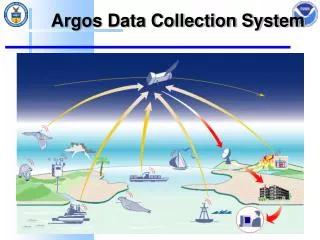
Argos Data Collection and Location System Platforms transmit data up to passing satellite…and satellite transmits data down to ground stations. Data is processed & distributed to customers/users…including GTS for met-ocean data. (Platforms w/o GPS are located using Doppler shift calculations.)
Current Argos DCS Satellite Network N19 MetOp A N18 N16 1800 Local time 0600 Local time N15 N17 1200 local sun time
Local HRPT Network This “real-time” network decreases data delivery time from >3 hrs for stored data to 15-20 minutes when both a platform and an HRPT Station are in view of a passing satellite.
Applications • Major Platform Types • Global Environmental Data • Key Global Successes (over last 20 years)
Major Platform Types (Number of Active Platforms)
Global Environmental Data • Oceanic & Atmospheric Observations are used for: • Weather Analyses & Forecasts • Tropical Cyclone Forecasting • Climate Studies & Predictions • Argos Data Global Telecommunication System (GTS) • ~1,600 WMO Platforms • ~50,000 Text Bulletins (daily) • GTS Global Atmospheric & Oceanic Models • GTS data are exchanged according to WMO Resolution 40. • Annex 1 to the resolution defined “essential” data and products to be exchanged without charge and with no conditions on use. All available in situ observations from the marine environment as well as upper air observations are regarded as “essential” by the resolution.
NOAA Numerical WeatherPrediction Models http://nomads.ncdc.noaa.gov/data.php
NOAA Climate Models http://nomads.ncdc.noaa.gov/data.php
Key Global Successes(over last 20 yrs) • Ability to monitor ENSO & predict the onset of El Nino events in the tropical Pacific. • Increased accuracy & capabilities of both weather forecasting & climate monitoring/predicting. • Improved hurricane predictions due to increased understanding of air-sea mixing. • Better understanding of the ocean in 4-dimensions with use of global profiling floats. • 3D hindcast-nowcast-forecast of global ocean.
Key Global Successes(over last 20 yrs) • Marine environmental safety services; e.g., “Eddy Watch” in Gulf of Mexico. • Rewriting textbooks on migration habits & patterns of wide range of wildlife. • Fishery management plans on a global basis. • Anti-piracy alerting for hijacked ships at sea. Photo by Naoto Honda, Japan’s Fisheries Agency
Future Plans • Space Segment: • 2011: SARAL launch in 0530 orbit • 2012: MetOp-B launch in 0930 orbit (followed by MetOp-C in ~2016) • 2016-2022: JPSS launches (spacecraft/orbits TBD) • Ground Segment: • 2011-2012: • Antarctica Telemetry Station • Optimize HRPT Network for all satellites • Advanced Argos-4 Instrument (for JPSS+): • Expanded bandwidth • Increased receiver sensitivity and data throughput • Two-way communications, using spread-spectrum for downlink
Thank You For more information http://noaasis.noaa.gov/ARGOS http://www.argos-system.org
Other Environmental Applications: USCG SLDMBs(2010) The U.S. Coast Guard uses Argos for their Self-Locating Data Marker Buoys, which are deployed to collect drift data for Search & Rescue cases. In 2010, 350 SLDMBs were deployed in the Atlantic, Caribbean, Great Lakes, Gulf of Mexico, and Pacific.
Most recent System Use Agreement approved by NOAA… Meteorologists and Oceanographers… Do you remember studying Rossby Waves? Rossby waves are named after Carl-Gustav Rossby (1989-1957). His son Thomas is a professor at the Graduate School of Oceanography at URI. Dr. Thomas Rossby is a world-renowned physical oceanographer and co-creator of the SOFAR float. Dr. Rossby’s latest project will use RAFOS floats to determine the mean & time-dependent circulation of the Lofoten Basin Mode Water layer, estimate vortex properties, and diagnose the routes by which the cooled products are subsequently exported. The work is part of an NSF-funded collaborative project with the Woods Hole Oceanographic Institution & NorthWest Research Associates, Inc. This is a new Argos DCS agreement under the “Oceanography” application. Argos was selected because of the need for polar coverage, location accuracy, service continuity & reliability, platform compatibility, and system access.