Download
1 / 14
140 likes | 250 Views
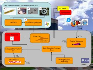
GOES Data Collection System (DCS) in the GOES R Era. William E. Brockman Short & Associates, Inc. What is GOES DCS. Data Relay System Used for Transmission from Ground-Based Sensors through Satellite to Receiving Station. Carried on board NOAA Geostationary satellites since 1970’s.

E N D
GOES Data Collection System (DCS) in the GOES R Era William E. Brockman Short & Associates, Inc.
What is GOES DCS Data Relay System Used for Transmission from Ground-Based Sensors through Satellite to Receiving Station. Carried on board NOAA Geostationary satellites since 1970’s.
Current Performance • Number of Platforms - 20,000 • Observation Period – 6 hours • Message Size – 200 bytes • Data Throughput – 100/300/1200 selectable
Current Users • Domestic and international government agency users exclusively. Principal users are: • NOAA line Offices • U.S. Geologic Survey • Army Corps of Engineers • USDA Forestry Service • National, State, and Canadian Fire Agencies • Bureau of Land Management • National, State, and local water resource agencies • International Hydromet Services
Requirements Process • Surveyed current and potential users requesting statements of requirements for GOES R era • Organized requirements into spreadsheet and database • Validated of requirements by interview and formal review process
Requirement Parameters • DCP Type • DCP Owner • DCP User & Priority • Level • Geographic Coverage • Number of Platforms • Transmissions/platform • Message Size • Data Throughput Rate • Data Latency • Accuracy (Transmission Timing) • Accuracy (error rate) • Notes • Source
Observation Categories • In the Water • On the Surface of the Water • On Land • In the Atmosphere • Other Services
Observing in the Water • Fish Counting Platforms • Stream/River Gauges • Water Quality Monitors
Observing on the Water • CMAN Stations: self-timed • Drifting Buoys • Dynamics of Earth and Ocean Project (DEOP) • Flood Gauges (Stream/River Gauges) • Moored Buoys: interrogate • Moored Buoys: self-timed • Shipboard Wx Obs Platforms • Tide Gauges • Tsunami Warning Stations • Tsunami Warning Stations (moored buoys)
Observing on Land • Fire Monitoring Stations • International Climate Reference Network • Rain Gauges • Seismic Monitors • U.S. Climate Reference Network • Volcano Monitors • Weather Observing Platforms
Atmosphere Observing • Aircraft RADAR • Aircraft Observations • Air Quality Monitors • GPS Met • Rawinsonde
Other Services • In support of NOAA Ships • E-mail • Internet / Intranet • NAV / Safety / Security • Quality of Life / Entertainment • In support of Marine Sanctuaries • Telepresence
Threshold Message Size =>200B 72% =>300B 21% Transmission Frequency 15min 67% 60min 30% Data Throughput Rate 100/300/1200b 96% Objective Message Size =>1000B 31% =>2000B 64% Transmission Frequency 5min 38% 15min 58% Data Throughput Rate 100/300/1200b – 51% 9600b – 47% Typical Performance Requirements