Download
1 / 13
130 likes | 239 Views
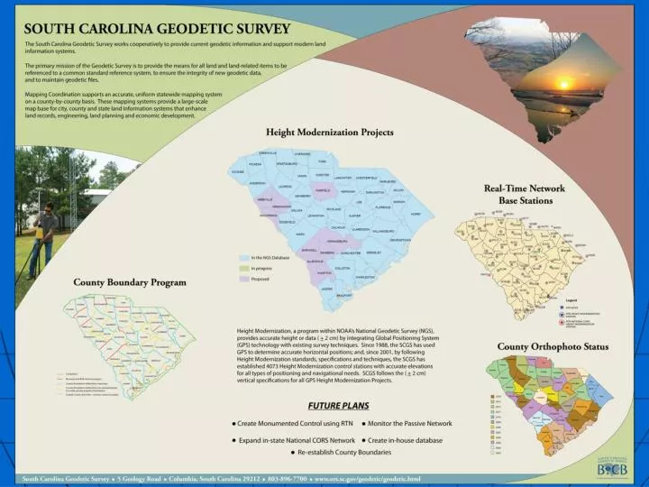
Mission Statement. SC Height Modernization Status. In the NGS Database (Height Mod Project). In progress. Proposed. Height Modernization Goals. Complete Height Mod survey in all 46 counties.

E N D
SC Height Modernization Status In the NGS Database (Height Mod Project) In progress Proposed
Height Modernization Goals • Complete Height Mod survey in all 46 counties. • When performing reconnaissance, attempt to recover all possible bench marks and determine if site is GPSable. These observations are used when improving the geoid. • Make ties to historical tide gages and barrier islands. • Ensure all of the SC RTN sites have Height Mod coordinates. • Monitor and create Height Mod control using the states RTN. • Create a database for geodetic control.
Accomplishments The SCGS has performed Height Mod surveys for 80% of the counties in the state. The SCGS just completed one regional project that added control to three different counties. With these projects, a total of 170 monuments with + 0.02 m 3D control have been added. The SCGS has collected QA/QC data using the SC RTN for counties as LiDAR checkpoints. We have done this as an in-kind service for four years. South Carolina Height Modernization Projects December 2013 In the NGS Database (Height Mod Project) In Progress Proposed
The South Carolina Real Time Network NCSP NCSH NCHE NC77 NCMR NCPO NCRO NCLU NCWH NCSL GACC SC Real Time GPS Network (SC RTN) SC RTN comprised of 53 base stations continuously collecting and transmitting GPS data SC RTN provides real time corrections, via cell phones, to users in the field operating GPS equipment Users in the field provided with real-time coordinates and elevations accurate to + 0.1 foot 471 Subscribers to the SC Real Time Network include, but are not limited to: Registered Professional Land Surveyors and Engineers Geographic Information System (GIS) Professionals Federal, State, County and Municipal Planners SCDOT and SCDOT Contractors using GPS Machine Control for Road Construction The Army Corps of Engineers SCHA Legend RTN SITES SCEB HEIGHT MOD STATION PROPOSED SITES
NGS 58/59 Height Modernization Survey NGS published guidelines for using static, post-processing GPS technology to establish accurate ellipsoid heights (NGS 58 in 1997) and accurate orthometric heights (NGS 59 in 2008) on passive control. data was collected both for post-processing and as real-time solutions. Real-time data collection shall consist of a series of six fixed-integer positions, with the following durations: 5 sec, 30 sec, 1 min, 3 min, 5 min, and 10 min (all using the same initialization). This will be done in four separate sets: as RTN and single-base RTK, both with GPS+GLONASS and GPS only.
Biggest Challenges Investigate the use of Trimble Business Center in lieu of Trimble Geomatics Office Creating a database for SC. Funding – Need I say anymore?
Thank-you! Matt Wellslager South Carolina Geodetic Survey 5 Geology Rd Columbia, SC 29212 803-896-7715 Matt.wellslager@rfa.sc.gov