Download
1 / 28
300 likes | 514 Views
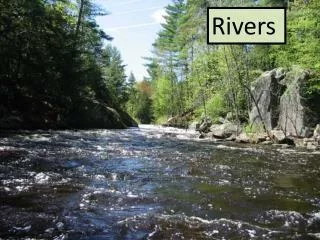
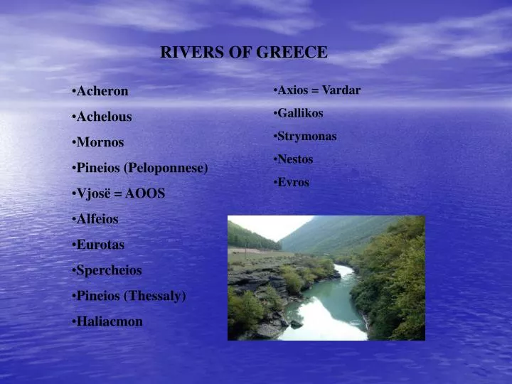
RIVERS OF GREECE. Acheron Achelous Mornos Pineios (Peloponnese) Vjosë = AOOS Alfeios Eurotas Spercheios Pineios (Thessaly) Haliacmon. Axios = Vardar Gallikos Strymonas Nestos Evros. Acheron

E N D
RIVERS OF GREECE • Acheron • Achelous • Mornos • Pineios (Peloponnese) • Vjosë = AOOS • Alfeios • Eurotas • Spercheios • Pineios (Thessaly) • Haliacmon • Axios = Vardar • Gallikos • Strymonas • Nestos • Evros
Acheron In ancient Greek mythology, Acheron was known as the river of pain, and was one of the five rivers of the Greek underworld. In the Homeric poems the Acheron was described as a river of Hades, into which Cocytus and Phlegethon both flowed. The river Achelous begins at about 2,000 metres (6,600 ft) elevation on the eastern slope of Lakmos mountain in the Pindus range, near the village Milea in the Trikala Prefecture. One of its first tributaries is the Aspropotamos, meaning the white river. Achelous River The Achelous (Greek: Αχελώος), also Acheloos, is a river in western Greece. It formed the boundary between Acarnania and Aetolia of antiquity. It empties into the Ionian Sea. In ancient times its spirit was venerated as the river god Achelous. The previous name was Thoas. It is rarely known as Thestios and Axenos
Mornos The river begins in the Oiti mountains near the Fthiotida prefecture to the north, it flows through the village of Marmarolithi and into several villages in a valley rich in forest, it enters the Mornos Dam which supplies water to the prefecture and a part of the river for nearly 6 km is the Mornos Reservoir or the Mornos Lake. It flows west of Lidoriki and into a forested valley and the old GR-48 runs within its valley for the entire length and the rest of the length forms a boundary with the Aitoloakarnania prefecture, it flows near the villages and towns of Koupaki, Trikorfo, Dafni and between Kastraki and Nafpaktos and it empties to the west of the Gulf of Corinth about 1 km south of the GR-48/E65.
Pineios (Peloponnese) The Pineiós (Greek: Πηνειός, also Pineus) is a river in Peloponnese, Greece. It is probably not named after the god Peneus. It flows from the mountain Erymanthus (Olonos), and empties into a bay SW of Gastouni connecting the Ionian Sea. The river flows through the southern half of the Ilia plain.In the 1960s, the government began building an earth-shaped dam named the Peneus Dam (ΦράγμαΠηνειούFragma Pineiou) to supply water for the north. The water is not safe for drinking, because it contains some contaminants. In Greek mythology, the Peneus and Alpheus were two rivers re-routed by Heracles in his fifth labour in order to clean the filth from the Augean Stables in a single day, a task which had been presumed to be impossible.
Vjosë = AOOS The Vjosë (Albanian indefinite form, the definite form is Vjosa) or Aoos (Greek: Αώος, Latin: Aous) is a river in northwestern Greece and southwestern Albania. Its source is in the Pindus mountains, in Epirus, near the village Vovousa. It flows through the Vikos-Aoos National Park, where it forms impressive canyons. It flows through Konitsa, and enters Albania near Çarshovë. It continues northwest through Përmet, Këlcyrë, Tepelenë, Memaliaj, Selenicë and Novoselë. It flows into the Adriatic Sea, northwest of Vlorë.
Alfeios Alfeiós (Greek: Αλφειός, also romanized as Alpheus, Alpheios, Alfiós) is a river in Peloponnese, Greece. Its source is near Megalopoli in the prefecture Arcadia. It flows along Olympia and empties into the Ionian Sea in the prefecture of Ilia, near Pyrgos. As the longest river in the Peloponnese, at 110 km, the river flows in the prefectures of Arcadia and Ilia
Eurotas (river) The Eurotas or Evrotas (Greek: Ευρώτας) is the main river of Laconia prefecture (Peloponnese, southern Greece). The river's big karstsprings are just northwest of Laconia's border with Arcadia prefecture. The waters of the 82 km long riverHistorically the Evrotas in its geological topography often flooded the plains also ruining properties as in 1999.
Spercheios The Spercheios (Greek: Σπερχειός, Latin: Spercheus) is a river in the Central Greece geographical region, of Greece. The river begins in Eurytania Prefecture in the Panaitoliko mountains and flows northeast from near Megalo Chorio
Pineios (Thessaly) The Pineiós (Greek: Πηνειός, also Peneus) is a river in Thessaly, Greece. The river is named after the god Peneus and was known for most of the 1000s as the Salambria. It flows from the Pindus mountains and empties into the Aegean Sea, northeast of Tempe, near Stomio. It creates a large delta, well-known for its beauty and for many animal species, protected by international environmental treaties. The total length is 185 km and it begins in the north at the Pindus ranges east of Metsovo.
The Haliacmon (Greek language: Ἁλιάκμων, Haliákmōn, or modern Αλιάκμονας, Aliákmonas. Is the longest river in Greece, with a total length of 322 km (200 miles). Haliacmon is the traditional English name for the river, but many sources cite the formerly official katharevousa version of the name, Aliákmon. Today, the only official variant is the demotic Aliákmonas. It rises in the northern Pindus mountains in northern Greece on the border with Albania, before flowing southeast then northeast through the Greek peripheries of West and Central Macedonia and then into Lake Kastoria, and into the dam and into the Thermaic Gulf. It waters an extensive area, making it of great importance to agriculture in the region.
AXIOS = Vardar The Vardar or Axios (Macedonian: Вардар, Greek: ΑξιόςAxiós or ΒαρδάρηςVardárīs) is the longest and major river in the Republic of Macedonia and also a major river of Greece. It is 388 km (241 mi) long, and drains an area of around 25,000 km2 (9,653 sq mi). The maximum depth of river is 30 m (98 ft). Emptying into the Aegean Sea. Vardaris/Vardarec wind The Vardaris or Vardarec is a powerful prevailing northerly ravine wind which blows across the river valley in Greek Macedonia as well as in the Republic of Macedonia.
Gallikos (river) Galikos (Greek: Γαλλικός is a river in Central Macedonia, Greece. It was known as Echedoros (Εχέδωρος) in antiquity and Gomaropnichtis (Γομαροπνίχτης) in Middle Ages. It rises in the Krousia Mountain and flows into the Aegean Sea in the Thermaic Gulf, near Sindos. The length of Galikos is 65 km.
STRYMONAS The Struma or Strymónas is a river in Bulgaria and Greece. Its ancient name was Strymōn (Greek: Στρυμών. Its catchment area is 10,800 km². It takes its source from the Vitosha Mountain in Bulgaria, runs first westward, then southward, enters Greek territory at the Kula village and flows into the Aegean Sea, near Amphipolis in the Serres prefecture. The river's length is 415 km (of which 290 km in Bulgaria, making it the country's fifth longest).
EVROS The Maritsa or Evros Modern Greek: Έβρος, is with a length of 480 km, the longest river that runs solely in the interior of the Balkans. It has its origin in the Rila Mountains in Western Bulgaria, flowing southeast between the Balkan and Rhodope Mountains. He enter the Aegean Seawhere it forms a delta.
ACARNANIAN MOUNTAINS The Acarnanian Mountains (Greek: Ακαρνανικό, Modern: Akarnaniko, Katharevoussa: Akarnanikon) is a mountain range dominating the northwestern part of the Aitolia-Akarnania prefecture in western Greece. Its length is approximately 20 km long and its width is approximately 10 km wide. The Ionian Sea lies to the west. The mountains are famous for its production of spring water. The spring water is bottled on the northern end of the mountains and is named Korpi. The main road linking Vonitsa and Astakos lies in the western part.
ATMAMANIKA Athamanika or Tzoumerka (Greek: Αθαμανικά or Τζουμέρκα) is a mountain in the northeastern Arta Prefecture, the southeastern Ioannina Prefecture and the southwestern Trikala Prefecture. The mountain is a part of the Pindus mountain range. Its maximum elevation is 2,393 m. The Arachthos river flows to the west.
GIONA Mount Giona (Greek: Γκιώνα, also transliterated as Gkiona) is a mountain in Central Greece, in the prefecture of Phocis, located between the mountains of Parnassus and Vardousia. Known in classical antiquity as the Aselinon Oros (Greek: Ασέληνονόρος, 'moonless mountain'), it is the highest mountain south of Olympus and the fifth overall in Greece. Pyramida is its highest peak at 2,510 metres (8,235 ft).
OLYMPUS Mount Olympus (Greek: Όλυμπος ; also transliterated as Ólympos, and on Greek maps, Óros Ólimbos) is the highest mountain range in Greece, its highest peak Mýtikas rising to 2,919 metres high (9,577 feet). It is one of the highest peaks in Europe. It is located in the borders of Thessaly and Macedonia, about 100 km away from Thessaloniki, Greece's second largest city. Mount Olympus is noted for its very rich flora with several endemic species. Mitikas is the highest peak in Greece, the second highest being Skolio (2912 m). In Greek mythology the mountain was regarded as the "home of the gods", specifically of the Twelve Olympians, the twelve principal gods of the ancient Hellenistic world.
OSSA Mount Ossa (Greek: Όσσα), alternative Kissavos (Greek: Κίσσαβος), is a mountain in the Larissa prefecture, in Thessaly, Greece. It is located between Pelion to the south and Olympus to the north, separated from the latter by the Vale of Tempe, with its height at 1,978 metres (6,490 ft). In Greek mythology, the Aloadaes are said to have attempted to pile it upon Mount Pelion, in their attempt to scale Olympus.
PANACHAICUS The Panachaicus (Greek: Παναχαϊκό, ancient forms, Panachaikon, Panachaiko is a mountain range that spans about 20 km in length from north and south (Glafkos, to the Psathopyrgos, and 15 to 20 from east to west (east of Patras to west of Seliantika). It is the northernmost mountain range in the Peloponnese. The highest point is 1,928 m, some marked it at 1,924, 1,925, and 1,926 m. The mountain is home to the skiing resort which can be seen from almost all of Patras.
PINDUS The Pindus (also Pindos or Pindhos) (Greek: Πίνδος) mountain range is located in northern Greece and southern Albania. It is roughly 160 km long, with a maximum elevation of 2637 m (Mount Smolikas). Because it runs along the border of Thessaly and Epirus, the Pindus range is often called the "spine of Greece". The mountain range stretches from near the Greek-Albanian borders in Northern Epirus, entering the Epirus periphery and Macedonia region in northern Greece down to the north of the Peloponnese.
DOIRAN LAKE Doiran Lake (Greek: ΛίμνηΔοϊράνη, Límni Doïráni) is a lake with an area of 43.1 km² shared between the Republic of Macedonia (27.3 km²) and West Macedonia within Greek Macedonia, Greece (15.8 km²). To the west is the city of Doiran, to the east the village of Mouries, to the north the mountain Belasica/Beles and to the south the Greek town of Doirani. The lake has a rounded shape, a maximum depth of 10 m and a north-to-south length of 8.9 km and is 7.1 km at its widest, making it the third largest lake partially in the Republic of Macedonia after Lake Ohrid and Lake Prespa.
LAKE OF IOANNINA The Lake of Ioannina (Greek: Limni Ioanninon (ΛίμνηΙωαννίνων)), also Pamvotida (Παμβώτιδα, older form: PamvotisΠαμβώτις) is Epirus' largest lake located near the central part of the Ioannina prefecture in Greece. Ioannina to the west and the town or Perama to the north are urban settlements fringing the lake while the remaining of its periphery is composed of farmland. The lake features small fishing ports and a boating port while the island is situated in the east of the lake. There is a regular boat service to the island (Nisi). Mountains lie further north and south with Mitsikeli overhanging the east part of the lake.
Lake Orestiada (also Lake Orestida) or Lake Kastoria (Greek: ΛίμνηΟρεστιάδα) is a lake in the Kastoria Prefecture of Macedonia, northwestern Greece. Sitting at an altitude of 630 meters, the lake covers an area of 28 square kilometers. Nine rivulets flow into the lake. Its depth varies from nine to ten meters. The Orestida was formed ca. 10 mya ago. The Kastoria Peninsula (with the town of Kastoria) divides the lake into two parts, the larger to the north and the smaller to the south. The lake takes its name from the Oreiades. Lakeside attractions include, apart from the Byzantine architectural heritage of the town, an 11th-century Byzantine monastery of the Panagia Mavriotissa and the reconstructed prehistoric settlement of Dispilio, where the Dispilio Tablet was retrieved from the lake in 1992.
LAKE KORONEIA Lake Koroneia (Greek: ΛίμνηΚορώνεια) is a lake in the heart of the prefecture of Thessaloniki in the Mygdonian basin in the Langada province, Greece. The lake is also known as Agios Vasileios from an homynous village or Lake Langada. It is located a few kilometres east of downtown Thessaloniki and in the north side is the Via Egnatia and the south is the old highway. The municipalities with shores on the lake are Koroneia, Langadas, and Egnatia.
BIG - SMALL PRESPA Prespa is the name of two freshwater lakes in southeast Europe, shared by Greece, Albania, and the Republic of Macedonia. Of the total surface area, 190 km² belongs to the Republic of Macedonia, 84.8 km² to Greece and 38.8 km² to Albania. They are the highest tectonic lakes in the Balkans, standing at an altitude of 853 m (2,798 ft). The Great Prespa Lake (Greek: ΜεγάληΠρέσπα) is divided between Albania, Greece and the Republic of Macedonia. The Small Prespa Lake (Greek: ΜικρήΠρέσπα) is shared only between Greece (138 km² drainage area; 43.5 km² surface area) and Albania (51 km² drainage area; 3.9 km² surface area). The largest town in the Prespa Lakes region is Resen in the Republic of Macedonia.
LAKE TRICHONIDA Lake Trichonida, also Trihonida or Trikhonida (Greek: Τριχωνίδα), older forms: Trihonis and Trikhonis ancient: Trichonis is the largest natural lake in Greece. It is located in the eastern part of the Aitoloakarnania prefecture and is located east of Agrinio, south of Evrytania and northwest of Nafpaktos. The area is 98.6 km² with the length of 19 km and the depth of 58 m. The lake used to cover the central part of the prefecture as well, and a million years ago was large enough to cover the central part of the modern prefecture, a part that is now a plain. The lake later dried up and is in the eastcentral portion of the prefecture today. Around the lake are beautiful forests with maples, pines and other trees. The lake and environs is home to about 200 birds. Close by there is also farmland and various villages, one of them being Myrtia.
LAKE KERKINI Kerkini (Greek: Κερκίνη) is a municipality in the Serres Prefecture, Greece, named after ancient Kerkinitis lake. Population of municipality 10,037 (2001). The seat is in Rodopoli.