Download
1 / 14
140 likes | 249 Views
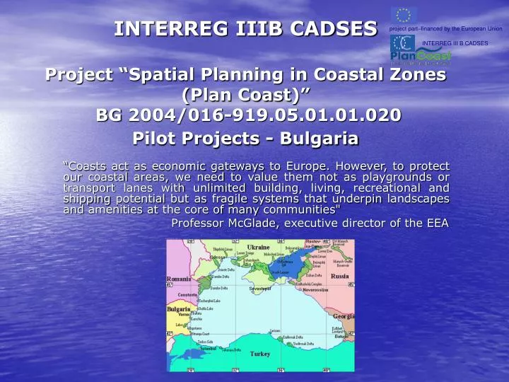
project part – financed by the European Union. INTERREG III B CADSES. INTERREG IIIB CADSES Project “Spatial Planning in Coastal Zones ( Plan Coast ) ” BG 2004/016-919.05.01.01.020 Pilot Projects - Bulgaria.

E N D
project part–financed by the European Union INTERREG III B CADSES INTERREG IIIB CADSES Project “Spatial Planning in Coastal Zones (Plan Coast)”BG 2004/016-919.05.01.01.020 Pilot Projects - Bulgaria “Coasts act as economic gateways to Europe. However, to protect our coastal areas, we need to value them not as playgrounds or transport lanes with unlimited building, living, recreational and shipping potential but as fragile systems that underpin landscapes and amenities at the core of many communities" Professor McGlade, executive director of the EEA
Pilot Projects’ Objectives and Indicators: Objectives: To improve the quality in the assessment, planning and management of spatial processes in coastal and maritime zones, according to the principles of ICZM and the implementation of best trans-national practices. Indicators: The selection of pilot projects is a possibility to cover and present different types of coast and aqua territory, rendering account of the following indicators: • Geological and morphological characteristics of the marine coastal zone; • Marine hydro- and litho-dynamics; • Hydrochemistry of the Black Sea; • Biological resources of the Black Sea; • Risks: frequency and intensity of the storms, landslides; • Concentration of economicactivities– industrial and warehouses’ zones at the coastal line; ports; fishery and aquacultures; gas extraction; tourism; • Marine activities - navigation, shipping; • Off-shore sea-waters’ zoning, according to the Water Framework Directive; • Natural areas and resources, subject to protection with priority.
Pilot Projects’ contents: І. Pilot Project: “GIS databasefor 12sm aqua-territorial zone and the coastal zones of Varna Region from Ekrene cape to Paletza cape” Stages: 1. Design of GIS database and information’s computer modeling. 2. Collection and input of data in GIS database for the project’s territorial scope about: - Geological and morphological conditions in coastal zones; - Natural risks; - State of thehydro-chemicalconditions; - State of biological resources and Marine Hydrobiology; - Natural areas and resources – a general map of the coastal habitats and of the spread of fauna with priority to be protected; - GIS database for thecoastal zone/the spatial planning zone/; - Information, submitted by other institutions.
Pilot Projects’ contents: ІІ. Pilot project: “Sea-use planning of the 12sm aqua-territorial zone of Varna Region from Ekrene cape to Paletza cape” Stages: 1. Establishment of the current status of the marine and coastal zones. 1.1. Geomorphological and morphostructural zoning of the coastal vulnerability. 1.2. Quantitativeevaluation of the erosion’s and landslide’s processes of the coast. 1.3. Determination of the morphodynamical characteristics of the coastal zone. 1.4. Determination of the lythodynamical characteristics. 1.5. Evaluation of the technogenic intervention on the basis of morphodynamical processes’ quantitativeevaluation. 1.6. Natural risks’ Evaluation and Level’s regime analysis. Prognoses of water levels’ increase in perspective of the next 20-25 years. 1.7. Wave influence’s Evaluation– a map of wave energy’s degree. 1.8. Establishment of the current status of hydrochemical conditions’ in the Black Sea. 1.9. Establishment of the current status of biological resources’.
Pilot Projects’ contents: 2.Current status of biological resources – biological indicators for evaluation of the aqua territory’s ecological status. 2.1. Biologicalevaluation of water ecosystems – Phytoplankton and Chlorophyll,bloomingspecies, ecological risk’s zones. Expected results: • Distribution Maps of: phytoplankton biomass; harmful bloomingspecies; chlorophyll; text’s analysis, tables and graphs of the key trendsofphytoplankton’s and chlorophyll,s distribution /ecological risk zones/. 2.2. Biologicalevaluation of water ecosystems – Zooplankton, indicative and invasional species, ecological risk zones. Expected results: • Distribution Maps of: biomass of the Mesozooplanktonal orders; number of indicative species Noctiluca scintillans; number of invasional species Mnemiopsis leidyi;text’s analysis, tables and graphs of Zooplankton’s characteristics in the aqua territory. 2.3. Biologicalevaluation of water ecosystems /fish resources – biodiversity, species threatened with extinction, migration, reserves, draughts, habitatswith priority significance. Expected results: • List of species of the ichthyofaunaandcharacterization of the migrations of the basic species and species threatened with extinction; trendsof industrial-exploitedreservesof the species; trendsof the draughts; distributionmap ofsignificant species.
Pilot Projects’ contents: 2.4. Biologicalevaluation of bottom’s ecosystems –bottom’s invertebrate fauna, sea bottom’s habitats, mussel’s banks, habitatswith significance, subject to priority. Expected results: • Maps of: aqua territory’secologicalstatus in accordancewith the biological element of the quality «bottom’s invertebrate fauna»; distribution of sea bottom’s habitats; zoneswith priority to beprotected - habitatsincluded in national and internationallegislation; percentageof themussel’s banks’coverage in the sonar-scanning fields; text’s analysis, tables and graphs of theaqua territorialzoo-bentnostical characteristics. 2.5. Biologicalevaluation of bottom’s ecosystems – Macroseaweed, indicative species and speciesthreatened with extinction, habitats, subject to protection with priority. Expected results: • Distribution Maps of:phytocenozes’ biomass/production; percentage of phytocenozes’surface; habitats of speciesthreatened with extinction; text’s analysis, tables and graphs of phytocenozes in the aqua territory.
Pilot Projects’ contents: 3. Preparation of a proposal for a sea-use-plan for the 12sm aqua-territorial zone of Varna Region from Ekrene cape to Paletza cape /on the territory of 3 municipalities – municipality of Varna, parts of the municipalities of Aksakovo and Avren/ Complex project suggestions, referring to: • Situationof the hydro-technical equipment for coast protection from abrasion, landslides, storms and rough water; • Territories and recreational resources in risk, recommendations and setting up of restrictive parameters for spatial planning in risk zones; • Hydro-technical equipment for tourism, situations’ decisions, constructiverequirements, ecological recommendations; • Development of fishery and aquacultures, fishing ports and stopping-places in the coastal zone, restricted draught’s zones, zones for special objects of industrial fishery and shell’s breeding. • Ports.
Pilot Projects’ contents: Map of the hydro-chemical indicators along the Bulgarian Black Sea coastin Varna Region
Pilot Projects’ contents: ІІІ. Pilot Project: “Specialized Spatial planning scheme for a part of the Black Sea coast of Varna Region within the boundaries from Paletza cape to Ekrene cape /on the territory of 3 municipalities - municipality of Varna, parts of the municipalities of Aksakovo and Avren Stages: 1. Elaboration of a Support Plan on the level of Specialized Spatial Planning Scheme, reflecting cadastral and other types of data about: - Situation, function and use of land property and buildings, within the boundaries of the administrative-territorial units and on territories with equal permanent function, exclusiveand public property along the coast, restraints on the rights of use; - Ground and underground main works and equipment of technical infrastructure, transport equipment; - Forests, agricultural land and relief according to topographic and specializedmaps, registers andinformationsystems of central andterritorial administrations. 2. Proposal for the boundaries and the extent of zones’ territories according to the Draft-Law on the Bulgarian Black Sea Coast Spatial Planning: zone “A”- with regime of specialized territorial-structural protection; zone “B” - with specialized territory’s characteristics and with specialized regime for protection of territorial and aqua territorial resources.
Pilot Projects’ contents: 3. Proposal for elaboration of a map-scheme of organization, including areas “A” and “B” and containing: - General structure and frame requirements for development of territory and aquatoryin zones“A” and “B”; - Necessary actions for coastal-protection according to aqua territorial prognosis and investigations; - Territories and zones, not allowed to new construction and extension of the constructions’ borders of the existing urbanised territories. Territories and zones with restrictive regimes of spatial planning; - Territories, destined for coastal parks and gardens; - Territories, destined for economic activity; - Objects of technical infrastructure with national and regional significance; - Actions for protection of the environment, the biological diversity, the naturalresourcesandculturemonuments; - General regime of use of water, woodland, land and recreational resources; - Recommendation for development of existing and future urbanised territories; - Specific requirements, rules and norms for spatial planning of the territory and aqua territory.
Pilot Projects’ contents: Map of theregions and sub-regionsdistribution along the Bulgarian Black Sea coastin Varna Region
Pilot Projects’ contents: Map of urbanised and protected territories in Varna Region
Expected impacts for Bulgaria: • GIS database, created and operational with up-to-date and internationally comparable data as a tool for ICZM implementation (ecosystem monitoring and spatial planning) • Basis laid for introduction of spatial planning according to ICZM principles in other coastal areas and sea-use-planning also in other 12sm maritime areas and EEZ of Bulgaria • Existing land use plans for coastal municipalities improved and new sea use plan developed, which will minimise existing and future identified conflicts leading to more investments (planning reliability), improved environmental conditions and more tourism (improved quality of coast) • Increased involvement and participation of all regional stakeholders in spatial planning processes • Increased awareness of coastal environmental problems and benefits of ICZM among all stakeholders • Appropriate means created for responsible authorities to implement ICZM in Varna Region • Improved coordination and integration among various institutions, authorities, organisations responsible for regional coastal management
project part–financed by the European Union Thank you for your Attention! INTERREG III B CADSES Contact: Bulgarian partner: Varna District Administration Preslav Str. 26, 9000 Varna Mr. Petar Kandilarov – District Governor Tel.+359 52/688 222, e-mail-governor@vn.government.bg Directorate for technical assistance, coordination and management of regional programs and plans: Mrs. Petya Nestorova, Tel. +359 52 /688 321, e-mail:regdir@vn.government.bg Directorate “Administrative Control, Regional Development, State Property”: Mrs. Diana Ilieva, Tel. +359 52 /688 324 e-mail:rr@vn.government.bg web-site:www.vn.government.bg