Download
1 / 30
400 likes | 936 Views
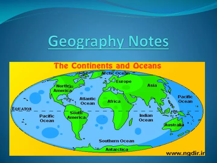
Geography Notes. Seven Continents:. Africa. Antarctica. Asia. Australia. Europe. North America. South America. Oceans of the World. Atlantic Ocean. Arctic Ocean. Indian Ocean. Pacific Ocean. Atlantic Ocean. Second Largest Ocean on Earth

E N D
Seven Continents: • Africa • Antarctica • Asia • Australia • Europe • North America • South America
Oceans of the World Atlantic Ocean Arctic Ocean Indian Ocean Pacific Ocean
Atlantic Ocean • Second Largest Ocean on Earth • Covers about one fifth of the earths surface = 20% • Located between the Americas to Europe and Africa. • The Prime Meridian runs through it. Arctic Ocean • Located in the Arctic Region • Smallest and Shallowest Ocean • Partly Covered with ice during the year
Pacific Ocean • The largest Ocean in the world • Lies between Asia and Australia on one side and the Americas on the other • Covers 30% of the worlds surface Indian Ocean • The third largest ocean • Blocked in by Africa, India, and Australia
The prime meridian and the equator divide the world into 4 hemispheres.
In which two hemispheres do you live?
Latitude and Longitude create an imaginary grid on Earth.
LATITUDE vs. LONGITUDE Longitude measures distance EAST and WEST of the Prime Meridian • LATITUDE measures distance NORTH and SOUTH of the EQUATOR
What are parallels? Parallels are lines that run from east to west. The Equator is O degrees latitude.
What are meridians? Meridians are lines that run from north to south. The Prime Meridian is O degrees longitude.
Parallels show us the LATITUDE of a location Merdians show us the LONGITUDE of a location 6. Parallels vs. Meridians
Latitude • Lines run East to West (or West to East) • Imaginary Horizontal Lines • The Equator is the Major line of Latitude • Lines of Latitude are measured in degrees • Lines go from 0 to 90 North and South.
Lines run North to South (or South to North) • Lines go up and down, or are Vertical • The main line of Longitude is the Prime Meridian = 0 degrees • The lines run from the North Pole to the South Pole • Lines are measured in degrees • Lines go from 0 to 180 in both directions, East and West Longitude
Equator • Line of Latitude • Runs around center of • Earth Horizontally • 0 N and S • Prime Meridian • Line of Longitude • Runs down the middle of the Earth Vertically • 0 E and W
Tropic of Cancer • Northern Tropic Line- anything below it to the Tropic of Capricorn is considered the Tropics. • Lies at 23.5 North Latitude.
Tropic of Capricorn • Southern Tropic Line- anything above up to Tropic of Cancer is considered tropics. • Lies at 23.5 South Latitude.
North Pole • It is located at 90 degrees north and is on the exact opposite side of the south pole. • All Longitude points start/converge at the North Pole making its east/west degree all of them. • The North Pole sits entirely over water. • Only partial frozen ice shelves float over the exact location of the North Pole.
South Pole • The southern most point on the Earth. • Is the exact opposite of the North Pole. • The continent of Antarctica sits on/underneath of the South Pole. • The Latitude is said to be 90 degrees south. • The longitude, like the North Pole, is all degrees longitude because all lines start/end there.
Arctic Circle • Is the line of Latitude that lies at 66 degrees north. • The area north of this line/circle is called the Arctic. • There are eight countries that have land located inside the Arctic Circle.
Antarctic Circle • Is located at 66 degrees south of the Equator. • The area located inside this line/circle is called the Antarctic. • Antarctica is the only continent that is located inside the Antarctic Circle. • Along with the Equator, Tropic of Cancer, Tropic of Capricorn, and Arctic Circle make up the Five Major Circles of Latitude.
A document, record, or written account made by someone who took part in or witnessed an event. • (diary, interview, • autobiography) Primary Source Prologue- Lesson 1: History Tells the Story of People on Earth
A written account made some time after an event has taken place and by people who were not eyewitnesses (newspaper, magazine article, biography, or textbook) Secondary Source SOCIAL STUDIES TEXTBOOK Prologue- Lesson 1: History Tells the Story of People on Earth
The compass rose points out directions. The tips of this compass rose point N, S, E, W,(Cardinal directions). NE,SE,NW, and SW (Intermediate) What is a compass rose?
What is a scale line? The scale line show how much smaller the map is than the actual area it represents.
What is an inset? The inset is related to the larger map. It shows details of a larger image.
What is a Key? The key explains what the symbols on the map mean.
What is a Projection? A Projection is different ways of showing the shape of the earth on a flat map. *Mercator *Robinson *Peters *Goode