Download
1 / 21
320 likes | 658 Views
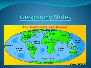
Year 6 Geography Revision Notes. Mapping Symbols. 16 point compass. Four figure grid references Let’s find grid square 21 31. To read a 4 figure grid reference go along to the line number of the first 2 numbers and then go up to the line with the second 2 numbers. .

E N D
Four figure grid referencesLet’s find grid square 21 31 To read a 4 figure grid reference go along to the line number of the first 2 numbers and then go up to the line with the second 2 numbers.
In order to give something a six-figure grid reference, imagine the larger square split into one hundred smaller squares. Then add numbers 1 to 10 between the main lines. 26 25 77 78
To work out the six-figure grid reference, first go along the bottom line and calculate the first three figures. Next, work out the last three figures by going up the side of the square. 26 9 8 So, the six-figure grid reference for the church is ..... 7 6 5 4 3 253 773253 2 1 25 1 2 3 4 5 6 7 8 9 77 78 773
Can’t remember which lines to use first? Try to remember this phrase: ‘Go along the corridor, then up the stairs’. c. R. Langley
Measuring distance on a map On the paper's edge One method of measuring distance is to take a sheet of paper and place the corner of a straight edge on your starting point. Now pivot the paper until the edge follows the route that you want to take. Step 1 Every time the route disappears or moves away from the straight edge of your paper, make a small mark on the edge and pivot the paper so the edge is back on course. Step 2 Repeat this process until you reach your destination. Step 3 You should be left with a series of marks along the edge of your paper. You can now place the sheet against the scale bar on your map. The last mark you made will tell you the real distance you need to travel.
Contour Patterns MOUNTAIN RANGES A CLIFF OR WATERFALL Contour lines are used to show height on a map. The closer the contours are together, the steeper the slope. The further apart they are the gentler the slope. By looking at contour patterns, we are able to work out the landscape A FLAT-TOPPED MOUNTAIN
Weather & Climate Britain’s Climate • Temperatures are higher in summer than in winter • Temperature are warmer in the south and colder further north. • In winter, temperatures tend to be warmer in the west and cooler in the east • Britain’s climate is a maritime climate ie it is affected by the sea. • The North Atlantic Drift is a warm ocean current, which raises the temperatures in the west, in the winter.
Different parts of the UK experience slightly different regional climates. • Northwest- cool summers, mild winters, heavy rain all year • Northeast - cool summers, cool winters, steady rain all year • Southeast- warm summers, mild winters, light rain all year, especially summer • Southwest - warm summers, mild winters, heavy rain all year, especially winter
Clear and Bright Black, low level cloud Clear sky DrizzleLight rain (day and night Sunny Partly cloudy Light rain shower WEATHER SYMBOLS Sunny intervals Heavy rain Hail Heavy snow shower Temperature Thundery shower
Types of Rainfall Stage 1. Warm wet air is forced to rise over high land. Stage 2. As the air rises it cools and condenses. Clouds form and precipitation occurs. Stage 3. The drier air descends and warms. Stage 4. Any moisture in the air (e.g. cloud) evaporates. Stage 1.An area of warm air meets and area of cold air. Stage 2.The warm air is forced over the cold air Stage 3.Where the air meets the warm air is cooled and water vapour condenses. Stage 4.Clouds form and precipitation occurs Stage 1. • The sun heats the ground and • warm air rises. Stage 2. • As the air rises it cools and • condenses to form clouds. Stage 3. • Large cumulonimbus • clouds are formed. Stage 4. • Heavy rain storms occur. These • usually include thunder and • lightening
BUILDINGS BUILDINGS SURFACE • Absorb heat & Reflect sunlight • Provide shelter form the wind • Can create shadows which lowers the temp. • Man made surfaces absorb heat (tar, concrete, bricks) • Natural surfaces like grass are cooler MICROCLIMATES - CLIMATE CONDITIONS IN A SMALL AREA which are different to the surrounding area PHYSICAL FEATURES SHELTER • Buildings, Fences, hedges, trees can all provide shelter from the wind, making the it slightly warmer • Mountains = colder temperatures because of the altitude • Water features lower temperatures ASPECT • The direction of an object in relation to the sun • Directly facing the sun makes it hotter, in shadow makes it colder
Coastal erosion Erosion works in four ways: • Hydraulic action - this results from the force of the water hitting the cliffs. Air, trapped in cracks, is compressed under high pressure, which breaks the rocks apart. • Corrasion- this is caused by the waves picking up stones and hurling them at the cliffs. • Corrosion [solution] - the dissolving of rocks by sea water. (Chalk and limestone) • Attrition- any material carried by the waves will become rounder and smaller over time.
Headlands and bays The shape of a coastline is often determined by its geology.(the rocks which make up the coastline) Some coastlines are very dramatic, with tall, vertical cliffs whilst others are straight for miles and miles whilst others are indented with many headlands and bays. When there are different rock-types along the coast, they may vary in their resistance to erosion. Some rock is harder and erodes more slowly forming headlands. Other rock is softer and erodes more easily forming bays .
Longshore Drift Sediment builds up due to Longshore Drift Groynes If the wind blows so that waves come in at a sharp angle to the coast, the swash carries the pebbles at an angle up the beach. When the backwash moves by gravity back down the beach, the pebbles end up at a different position. This process is repeated and pebbles gradually shift along the beach, a process called longshore drift. Waves approach beach at an angle