Download
1 / 52
520 likes | 680 Views
Geography notes for F.6. Natural Landscape. What is geomorphology?. It is the study of the origin and evolution of landforms on the earth ’ s surface . Most of the earth ’ s landforms are created mainly by tectonic or endogenic forces ( 內在 ) operating in the earth ’ s crust. Continental Drift.

E N D
Geography notes for F.6 • Natural Landscape
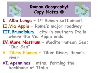
What is geomorphology? • It is the study of the origin and evolution of landforms on the earth’s surface . • Most of the earth’s landforms are created mainly by tectonic or endogenic forces (內在) operating in the earth’s crust.
Continental Drift • Alfred Wegener,published a book on continental drift in 1915. • His idea is widely accepted into the theory of plate tectonics
Evidence of continental drift • Geometric matching of continental borders (like jigsaw puzzle)
Geological evidence - the form and pattern of the ancient fold mountains - evidence yielded by rocks - belt of Mesozoic basalt (it can be find everywhere)
c) Biological evidence - diverse and specialised groups on various continental fragments
d) Palaeoclimatic evidence (史前氣候因素) • fossils found in conditions seem impossible - coal was found in Antarctica
e)Palageomagnetic evidence (古地磁學) - Palaeomagnetism is the study of earth magnetism during the geological past
- minerals sensitive to the magnetic field align themselves to the earth’s magnetic pole when it cooled and solidified
2. Seafloor spreading • It provide an explanation for continental drift • mid-oceanic ridge is formed • Evidence : Heat flow with minerals, young ocean floor and palaeomagnetic evidence
3. Plate tectonic • It is a theory combining the concepts of continental drift and seafloor spreading • It is divided into a number of plates “floating” on the asthenosphere • Volcanic and earthquake zones are confined to the plate boundary • The growth of new lithosphere below the ocean is balanced by the destruction of the lithosphere along the convergent boundaries
Causes of plate movement • Convection Currents • it is fuelled by radioactive process in the mantle • Difference heating in rock cause rising-sinking motions • It cause a dragging force on the lithospheric plate
The mechanism • all continents once formed one supercontinent called PANGAEA (聯合古陸) • It split into Laurasian and Gondwanaland
B Internal structure of the earth • Earth has a diameter of 6370 km and about 40000km in circumference • It consist of a solid crust (about 6km beneath the oceans and 35-40 km under mountains ) • A solid mantle(about 3000km thick) • A core (solid inner core and liquid outer core)
Moho (Mohorovicic Discontinuity)(莫霍界面) • The thickness of the earth is found by a Yugoslavian scientists ,Andrija Mohorovicic • It is the abrupt change (突然轉變)in density between the crust and the mantle • This boundary zones averages about 10 km below sea level in oceans basin and and about 30 km beneath high mountains
Some important terms • The mantle is much hotter than the crust .It compose of mineral olivine. • The density is 5g/cm • The inner core is solid while the outer core is liquid • Lithosphere is the crust and rigid uppermost parts of upper mantle,at a depth of about 100km • Asthenosphere (軟流圈)is a zone of weaker and more plastic rocks and extend to 240km
Waves • When an earth tremor(震動),primary and secondary waves are transmitted through the epicentre (震央),the point at which the earthquakes occur • Primary waves travel through solids and liquid while secondary waves travel through only solids
A. Constructive plate margin • It is a boundary where two plates move apart. A fissure develops,allowing hot ,molten rock to well up from the mantle and to from new materials as it solidifies,the fissure is called a spreading,or “pull apart” centre.
Mid- Atlantic ridge is a good example • It will cause volcanic activity, Iceland and the Azores • High magnitude volcanic eruptions on and around the ridges,volcanic island produced
B. Destructive plate margin • It is a boundary where two plates collide. The more dense plate will normally be deflected beneath the less dense plate,and will be destroyed and absorbed at depth. • Such action take place at the zone of subduction. Crumped (摺曲、扭曲) mountain ranges,volcanoes earthquakes and ocean trenches (海溝)are found
Three types of collision • Collision between oceanic plate and continential plate
Conservative plate margin • It is also called transform fault
Plate tectonics and Man • The existing features of the continents and ocean basins are explained by the theory of plate tectonic • Produce environmental hazards: volcanic eruptions and earthquakes • Produce mineral resources
Earthquakes • Magnitude of earthquakes refer to the energy released at the source • It is measured by either by Richter Scales (0-8logarithmic scale) (里氏震級表) or Mercalli Scales (12 gradations) • There is no direct relationship between the magnitude and the damage caused in the earthquake
Human Response to Earthquakes • Made seismic hazard zone maps for landuse planning • Man-made measure to trigger small earthquakes • Drills and shock-proof buildings are designed • Extensive monitoring of the earthquakes
Seismometers (地震儀)are used to detect small earthquake • Tiltmeters (傾斜儀) and electronic distance measurers (電子距離儀) are used to measure the shape of the volcanoes • Fertile soil is produced • Iron,copper,zinc,lead,uranium ,etc