Download
1 / 6
70 likes | 186 Views
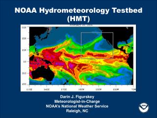
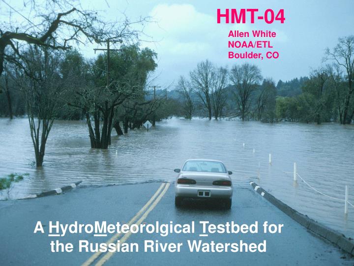
HMT-04. Allen White NOAA/ETL Boulder, CO. A H ydro M eteorolgical T estbed for the Russian River Watershed.

E N D
HMT-04 Allen White NOAA/ETL Boulder, CO A HydroMeteorolgical Testbed for the Russian River Watershed
HMT-04 is a demonstration project focused on improvements in quantitative precipitation estimation (QPE) and quantitative precipitation forecasting (QPF) in mountainous areas and is designed to help improve hydrologic forecasts and warnings. HMT will assess existing NOAA observational, modeling, and human infrastructure, identify critical gaps in NOAA’s current observing and modeling capabilities, and recommend how to fill those gaps based on proof-of-concept results.
HMT-04 will use a variety of ground-based remote sensing radars and in situ sensors, the data from which will be archived for future research and made available in near real time (~Dec 10 – Mar 31) on the internet for direct forecaster use and NWP evaluations. See: www.etl.noaa.gov/programs/2004/hmt/ 915-MHz wind profiler with RASS
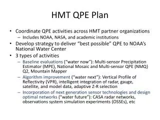
HMT-04:Coastal Gap-Filling X-band Radar NOAA/ETL X-band radar at FRS 0059 UTC 14 Jan 03 X-band 10 20 KMUX 30 40 0 5 10 15 20 25 30 Reflectivity (dBZ) at 0.5 deg elevation 50 WSR-88D radar at KMUX 0102 UTC 14 Jan 03 60 km Reflectivity (dBZ) at 1.0 deg elevation 0 10 20 30 40 50 • Nearest NEXRAD radar sees no significant echoes approaching flood-prone watershed • NOAA/ETL’s Coastal X-band radar fills NEXRAD gap
HMT-2004 A Hydrometeorological Testbed (HMT) for the Russian River Watershed BBY = Bodega Bay BSC = Big Sulfur Creek CVD = Cloverdale CZC = Cazadero FRS = Fort Ross GRK = Goat Rock HBG = Healdsburg HLD = Hopland LSN = Lake Sonoma ROD = Rio Dell SPT = Salt Point