Download
1 / 8
80 likes | 198 Views
HMT QPE Plan. Coordinate QPE activities across HMT partner organizations Includes NOAA, NASA, and academic institutions Develop strategy to deliver “best possible” QPE to NOAA’s National Water Center 3 types of activities

E N D
HMT QPE Plan • Coordinate QPE activities across HMT partner organizations • Includes NOAA, NASA, and academic institutions • Develop strategy to deliver “best possible” QPE to NOAA’s National Water Center • 3 types of activities • Baseline evaluations (“water now”): Multi-sensor Precipitation Estimator (MPE), National Mosaic and Multi-sensor QPE (NMQ) Q2, Mountain Mapper • Algorithm improvement (“water next”): Vertical Profile of Reflectivity (VPR), intelligent integration of radar, gauge, satellite, and model data, adaptive Z-R selection • Incorporation of next generation sensor technologies and design optimal networks (“water future”): CASA radar networks, observations system simulation experiments (OSSEs), etc
APPEND Strategy for QPE Activities • APPEND: AdaPtivePrecipitation Estimation Network Design • Evaluate QPE systems in different topographic/regional settings • Improve understanding of sensor networks, modeling tools, data assimilation in current QPE systems • “Smart” Integration of QPE from ground and satellite sensor,s as well as model QPF • Platform for incorporating new algorithms and future technologies • Design system to test new algorithms and future technologies • Guide decisions for NWC about QPE forcing in complex terrain
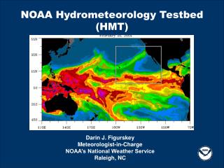
HMT QPE Activities • Evaluate and improve radar QPE in CA watersheds • In partnership with NSSL (MRMS) and Office of Hydrologic Development • Microphysical analysis leading to improvements in vertical profile of reflectivity correction and Z-R selection – American River Basin • Evaluation of QPE products in Russian River Basin (on-going) • Evaluation includes spatial pattern and amounts • Impact of sensors to resulting QPE • In partnership with NSSL (MRMS) • Evaluation of radar QPE in Colorado Front Range (on-going) • Warm season convection • Sensitivity of radar QPE in distributed hydrologic model (in partnership with NCAR) http://hmt.noaa.gov/
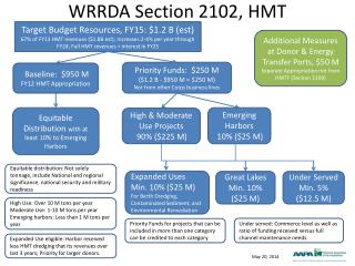
QPE Accomplishment: Assessment of Radar to QPE in American River Basin RMS Error Statistics I. Problem: QPE dependent on input data III. QPE Analysis Combined Q2-Gauge QPE Which analysis is “correct”??? • Merged radar-gauge QPE shows best performance (RMS, CC, and bias) • Results suggest that radar has a small, but positive impact on QPE in the ARB o BOWMAN DAM Gauge + o o 48-hr accum: 30 Dec 2005 – 1 Jan 2006 TRUCKEE o o GRASS VALLEY + + o Radar-Gauge Mosaic Gauge-Radar DMIP 2 ‘Basic QPE’ Radar + o Observed Flow Image courtesy of D. Kitzmiller o Gauge-Only ROBS PEAK Image courtesy of D. Kitzmiller IV. Impact on Hydrologic Runoff II. Methodology to Evaluate QPE Products Image courtesy of M. Smith Radar Only (88D) • Input gauges include NCDC and CDEC • References gauges are HMT and CDEC • Input radar includes NMQ Q2 and Stage II • All data input into MPE • Compare QPE: gauge-only, radar-only, combined radar-gauge • Evaluate sensitivity of hydrologic model (HL-RDHM) to QPE • All simulations predict peak runoff too early • Combined radar-gauge QPE produces simulation that is closest to observed Statistics for 1-H values REFERENCE GAUGE + Image courtesy of D. Kitzmiller o INPUT GAUGE
Radar-Only Gage-Adj_Radar Mountain-Mapper Gage-Only
Incorporate HMT and ALERT gauge data into verification analysis
2012 HMT QPF Activities • Experimental real-time national ensemble (~10 km) • Movable nest within the national ensemble (~3 km) • EMC and WRF microphysics validation • New reforecast database using the GFS • National extreme QPF performance base lining • Spatial verification techniques as applied to atmospheric rivers • Principle moisture sources and methods of transport in HMT-SE • QPE product development for input to NWP models • Winter Weather Experiment (HPC-HMT) • Spring Experiment in the Hazardous Weather Testbed (HPC-HMT) • AR Retrospective Forecasting Experiment