Download
1 / 35
370 likes | 628 Views
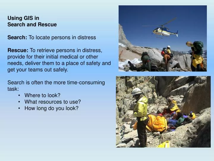
Using GIS in Search and Rescue Search: To locate persons in distress Rescue: To retrieve persons in distress, provide for their initial medical or other needs, deliver them to a place of safety and get your teams out safely. Search is often the more time-consuming task: Where to look?

E N D
Using GIS in • Search and Rescue • Search: To locate persons in distress • Rescue: To retrieve persons in distress, provide for their initial medical or other needs, deliver them to a place of safety and get your teams out safely. • Search is often the more time-consuming task: • Where to look? • What resources to use? • How long do you look?
A map is not the territory it represents, but if correct, it has a similar structure to the territory, which accounts for its usefulness. -- Philosopher and Scientist Alfred Korzybski, 1931
“What hampers me as a searcher is that I don't think like a lost person (well, mostly ...). Maybe one (two?!?) out of 10 times have I looked at a map, waved my divining rod over it and said: "There!" and been anywhere close to right. Each SAR is like learning all something new each time. So the priority tools (and tech devices), for me, would be those which contribute to better organizing and visualizing the SAR and the terrain.” Robert Koester, Lost Person Behavior
GIS & MapSAR Significantly Enhances Situational Awareness And Provides a Common Operating Picture
SAR Information and Resource Flowchart Field Updates Clues, Location, etc. Orders Debriefing Dispatcher Dispatcher Clues, Location, etc. Log Analysis Clues, Location, etc. Ops Search Lead Investigator Planning Investigator Dog Ops Air Ops Tasks Investigations Operations Walk, Ride, Fly Equipment Briefing Assignments Assignments Helos, Trucks Logistics Team Resource Unit
Common Operating Picture Available to All ArcGIS Explorer Desktop Spare Ovals Field Updates Clues, GPS Locations Debriefing Orders Flex Viewer To GIS Server Dispatcher Dispatcher Clues, GPS Tracklogs & Waypoints Log Investigations Analysis MapSAR ArcGIS 10 Ops Investigator Search Operations Dog Ops Clues Air Ops Planning Tasks Walk, Ride, Fly Maps: Team, Briefing Assignments Equipment Briefing Assignments Assets Teams Logistics Helos, Trucks Team Resource Unit
GIS & MapSAR: Capture spatial information in organized and retrievable structure.
Next: Quickly produce accurate team and briefing maps. Get teams into the field!
MapSAR: Allows automatic customization of team maps. DDP produces those maps quickly.
3D Image (ArcGIS Explorer or ArcGlobe): Effective Visualization of terrain for teams and Incident Command
ArcGIS Explorer can be set to poll data automatically, giving it the potential to be used as a semi-realtime situation map projected into the Incident Command Post.
SAR dispatch enters clues and team locations in networked geodatabase which become immediately available to Command staff.
Used with GIS Server, Dynamic & Enhanced Common Operating Picture
Analysis: Surface Created with Cross Country Mobility Analysis with Roads and TrailsDementia STATS
Training all team members in GIS: Use ArcGIS Explorer Desktop to capture initial reports and produce maps for initial hasty search.
Using GIS in SAR: Sometimes The Map is Not the Territory
Understand the mapping software you use. Practice with different types of coordinate systems and converting between them.
Team safety, situational awareness & speeding up planning cycle: remote tracking of field teams Infinity GPS MiiC: Tracking via radio system. Inmarsat BGAN Satellite communication: Phone & Internet GeoPro Messenger: Satellite Tracking & Messaging
Screen Capture GeoPro track projected onto ArcGIS Explorer, Zion National Park
When applied to GIS, Korzybski’s “the map is not the territory” is a warning not to make maps or computer analysis a substitute for local knowledge and a team’s skill. For all of this technology’s potential, the lost and injured are found and rescued by dedicated searchers working in difficult and dangerous conditions far from help themselves. Effective SAR is founded on the actions of searchers voluntarily leaving a warm and comfortable environment to go out in often horrendous weather and terrain to look for a lost person. SAR will always require people with specific knowledge of an area to be able to properly evaluate and make decisions based on that experience. GIS, though, is a vital tool to efficiently and effectively envision complex information – turning a flat piece of paper into a better approximation of the territory.
A Good Day for SAR: Yosemite Ranger Dave Pope with Child, Merced River, Yosemite National Park
George Durkee: gedurkee@sonic.net Using GIS in SAR for Emergency Responders:http://groups.google.com/group/sar-and-gis