Download
1 / 22
220 likes | 224 Views
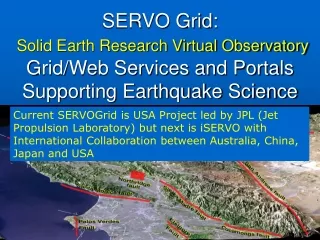
iSERVO and SERVOGrid: (International) Solid Earth Research Virtual Observatory Grid/Web Services and Portals Supporting Earthquake Science. Jan 16 2004 Los Angeles Geoffrey Fox Community Grids Lab, Pervasive Technologies Laboratories Indiana University.

E N D
iSERVO and SERVOGrid: (International) Solid Earth Research Virtual Observatory Grid/Web Services and Portals Supporting Earthquake Science Jan 16 2004 Los Angeles Geoffrey Fox Community Grids Lab, Pervasive Technologies Laboratories Indiana University
The Solid Earth Research Virtual Observatory A Web-based system for modeling multi-scale earthquake processes Andrea Donnellan, John Rundle, Geoffrey Fox, Marlon Pierce, Dennis McLeod, Jay Parker, Robert Granat, Terry Tullis, Lisa Grant
Solid Earth Research Virtual Observatory (SERVO) • Web-services and portlet based Problem Solving Environment (PSE) • Couples data with simulation, pattern recognition software, and visualization software • Enable investigators to seamlessly merge multiple data sets and models, and create new queries. • Data • Spaced-based observational data • Ground-based sensor data (GPS, seismicity) • Simulation data • Published/historical fault measurements • Analysis Software • Earthquake fault • Lithospheric modeling • Pattern recognition software • International Version iSERVO • Australia China and Japan
SERVOGrid Codes, Relationships (Workflow) Elastic Dislocation Inversion Viscoelastic FEM Viscoelastic Layered BEM Elastic Dislocation Pattern Recognizers Fault Model BEM
SERVOGrid Application Descriptions • Codes range from simple “rough estimate” codes to parallel, high performance applications. • Disloc: handles multiple arbitrarily dipping dislocations (faults) in an elastic half-space. • Simplex: inverts surface geodetic displacements for fault parameters using simulated annealing downhill residual minimization. • GeoFEST: Three-dimensional viscoelastic finite element model for calculating nodal displacements and tractions. Allows for realistic fault geometry and characteristics, material properties, and body forces. • VirtualCalifornia: Program to simulate interactions between vertical strike-slip faults using an elastic layer over a viscoelastic half-space • RDAHMM: Time series analysis program based on Hidden Markov Modeling. Produces feature vectors and probabilities for transitioning from one class to another. • PARK: Boundary element program to calculate fault slip velocity history based on fault frictional properties; a model for unstable slip on a single earthquake fault. • PDPC: Phase Dynamics Probability Change • Preprocessors, mesh generators • Visualization tools: RIVA, GMT
Data Access and Sharing, Code Integration • Codes all use custom text formats for describing input and output. • Input and output data often combined with code-specific information. • Number of iterations, array sizes, etc. • Data files often created by hand from journals, online repositories • Online repositories themselves use differing formats • Challenges are to develop common data formats, access services, and client query tools. • Solve by wrapping all codes as Web/Grid services
Web Services for Data Access and Computing Service Invocation • Web services: • WSDL: Interface definition language, describes your service • “GeoFEST may be invoked with these input types” • SOAP: Transport envelope for remote procedure calls/messages • “Invoke GeoFEST with this set of input” • Critical feature: all I/O message (not RPC) based • WSDL is message version of method calls • Together, WSDL and SOAP are useful for manipulating, returning XML data values • So GML schemas act as our data models and return values • Do not distinguish between Web and Grid services • Note OMII (Open Middleware Infrastructure Institute) will develop e-Science core technology • Currently only in UK but likely to spread • Wrappers convert conventional file/parameter I/O to Web Service messages
Nugget3 Nugget4 Interaction Nugget1 Nugget2 Data Building PSE’s with theRule of the Millisecond I • Typical Web Services are used in situations with interaction delays (network transit) of 100’s of milliseconds • But basic message-based interaction architecture only incurs fraction of a millisecond delay • Thus use Web Services to build ALL PSE components • Use messages and NOT method/subroutine call or RPC
Building PSE’s with theRule of the Millisecond II • Messaging has several advantages over scripting languages • Collaboration trivial by sharing messages • Software Engineering due to greater modularity • Web Services do/will have wonderful support • “Loose” Application coupling uses workflow technologies • Find characteristic interaction time (millisecond programs; microseconds MPI and particle) and use best supported architecture at this level • Two levels: Web Service (Grid) and C/C++/C#/Fortran/Java/Python • Major difficulty in frameworks is NOT building them but rather in supporting them • IMHO only hope is to always minimize life-cycle support risks • Science is too small a field to support much! • Expect to use DIFFERENT technologies at each level even though possible to do everything with one technology • Trade off support versus performance/customization
(i)SERVO Web (Grid) Services • Programs: All applications wrapped using proxy strategy as Services • Job Submission: supports remote batch and shell invocations • Used to execute simulation codes (VC suite, GeoFEST, etc.), mesh generation (Akira/Apollo) and visualization packages (RIVA, GMT). • File management: • Uploading, downloading, backend crossloading (i.e. move files between remote servers) • Remote copies, renames, etc. • Job monitoring • Workflow: Apache Ant-based remote service orchestration • For coupling related sequences of remote actions, such as RIVA movie generation. • Database services: support SQL queries • Data services: support interactions with XML-based fault and surface observation data. • For simulation generated faults (i.e. from Simplex) • XML data model being adopted for common formats with translation services to “legacy” formats. • Migrating to Geography Markup Language (GML) descriptions.
GML Schemas as Data Models for Services • Fault and GPS Schemas are based on GML-Feature object. • Seismicity Schema is based on GML-Observation object. • Working schema available from http://grids.ucs.indiana.edu/~gaydin/schemas/ • Work interfaced with openGIS Consortium who have well developed set of GIS Web services
The Next Generation Grid Portal(http://www.ogce.org) Event and logging Services The User Application Factory Services Messaging and group collaboration Portal Server Directory & index Services User's Persistent Context MyProxy Server Metadata Directory Service(s) • Building on Standard Technologies • Portlet Design (JSR-168) IBM, Oracle, Sun, BEA, Apache • Grid standards: Java CoG, Web/Grid Services • Web server: JetSpeed (open source) • User configurable, Service Oriented • Philosophy: The Portal is a gateway to distributed Grid and Web Services • With common API, portlets can be exchanged, interoperate
Collage of Portals Earthquakes – NASAFusion – DoE Computing Info – DoD Publications -- CGL
Portal Architecture Clients (Pure HTML, Java Applet ..) Aggregation and Rendering Portlet Class:WebForm Gateway (IU) Web/Gridservice Computing Remoteor ProxyPortlets Portlet Class:IFramePortlet Web/Gridservice Data Stores Portlet Class:JspPortlet GridPort etc. Web/Gridservice Instruments Portlet Class:VelocityPortlet (Java) COG Kit Hierarchical arrangement Jetspeed Internal Services LocalPortlets Clients Portal Portlets Libraries Services Resources (Jetspeed)
International iSERVO Resources • USC, Indiana and JPL are current USA resources • University of Queensland • Host resources: Web/compute server • Finite Element Application, “Finley” • Australian Fault Map data from Geoscience Australia • University of Tokyo • Linux server for Web server hosting • Finite Element Application, “GeoFEM” and related tools.
iSERVO Example: Finley • Finley is a finite element code being developed by the QUAKES group at the University of Queensland. • Compatible with GeoFEST-style geometry models and mesh generation tools. • So we can reuse the services we wrapped for GeoFEST. • The Finley application itself is a separate service and also has a separate (simple) visualization service.
Setting Up Finley Simulation of Northridge Selected Fault Components Select Fault from USC database