Download
1 / 6
60 likes | 153 Views
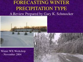
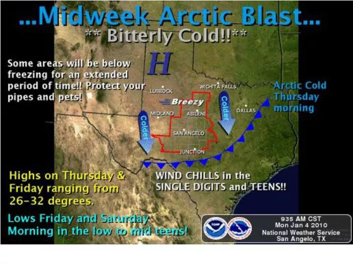
Liquid Precipitation Amounts Wed Night/Thurs. 32 F. 32 F. Dashed line is approximate location of freezing line at 6 AM Thursday. LIGHT SNOW. LIGHT SNOW. LIGHT FREEZING DRIZZLE. WINTER PRECIPITATION WED NIGHT/ THURS MORNING. RAIN MIXING WITH/ CHANGING TO LIGHT SLEET/SNOW.

E N D
Liquid Precipitation AmountsWed Night/Thurs 32 F 32 F Dashed line is approximate location of freezing line at 6 AM Thursday
LIGHT SNOW LIGHT SNOW LIGHT FREEZING DRIZZLE WINTER PRECIPITATION WED NIGHT/ THURS MORNING RAIN MIXING WITH/ CHANGING TO LIGHT SLEET/SNOW
Hazard Impacts to Texas Wednesday through Saturday Extreme cold over entire state Below freezing conditions for 36-48 hours over N TX Possible impacts to pipes/mains in nrn counties Mixed winter precipitation possible over C and E TX Thursday morning Accumulations light – travel problems mainly limited to bridges/overpasses Still considerable uncertainty on precipitation amounts and timing Light snow over N and W TX late Wed into Thurs morning Accumulations very light Light freezing drizzle in W TX Wed night