Download
1 / 16
160 likes | 358 Views
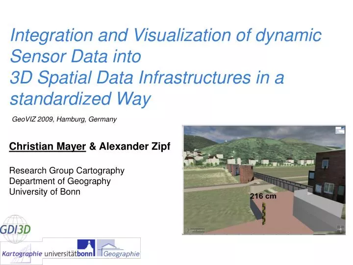
Integration and Visualization of dynamic Sensor Data into 3D Spatial Data Infrastructures in a standardized Way . GeoVIZ 2009, Hamburg, Germany. Christian Mayer & Alexander Zipf Research Group Cartography Department of Geography University of Bonn. Overview. Introduction Project GDI-3D

E N D
Integration and Visualization of dynamic Sensor Data into 3D Spatial Data Infrastructures in a standardized Way GeoVIZ 2009, Hamburg, Germany Christian Mayer & Alexander Zipf Research Group CartographyDepartment of Geography University of Bonn
Overview • Introduction • Project GDI-3D • Sensor Web & 3D • Summary & Outlook • Video Demo Christian Mayer, GeoVIZ Workshop 2009, Hamburg, Germany
Introduction SDIs today • Search, management and visualization of 2D spatial data (raster & vector) • Is this enough? • New applications are emerging: • processing and analyzing • mobile applications – LBS • 3D applications • Real-time data available Christian Mayer, GeoVIZ Workshop 2009, Hamburg, Germany
Introduction • Approach to integrate sensor data into 3D-SDI • Based on open standards of the OGC • Sensor Web Enablement (SWE) • Different use-cases to show potential • 3D-SDI Project GDI-3D Christian Mayer, GeoVIZ Workshop 2009, Hamburg, Germany
Project GDI-3D • Finding best practices for 3D data exchange, data preparation and user interaction • 3D-SDI based on relevant OGC services like WFS, WMS, CS-W, WCS • Web 3D Service (W3DS) > serving 3D scenes within a special 3D viewer • Test case: city of Heidelberg (www.gdi-3d.de) • German-wide 3D-SDI (www.osm-3d.org) Christian Mayer, GeoVIZ Workshop 2009, Hamburg, Germany
Project GDI-3D Sensor Observation Service HochwasserpegelLuftschadstoffeGebäudemonitor Catalog Service Web Metadaten zu Daten & Services Map 3D Client Visualisierung Interaktion Web Processing Service Analyse: Emmission, Bombenfund, Höhenprofil etc. OpenLS Directory Service Gelbe Seiten -Umgebungssuche W3DS 3D Stadt- und Landschaftsmodelle Route Service 3D Transformation 2D->3D Sensor Observation Service Dynamische Daten Windricht. / -stärke 3ddb OpenLS Utility Service Geocoder (reverse) Web Map Service 2D Karten Übersicht OpenLS Route Service Routenberechnng Web Processing Service Aufbereitung Geodaten (DGM, 2D, 3D) OLS Presentation Service Routenkarten Web Feature Service Geodatenbank Web Coverage Service Rasterdaten Christian Mayer, GeoVIZ Workshop 2009, Hamburg, Germany 6
Sensor Web & 3D OGC Sensor Observation Service • Web service for providing sensor data via internet • Standardized operations • getCapabilities • getObservation • insertObservation • ... • Data encoded in standardized XML-Schema (O&M) • Open Source implementation extended for 3rd Dim Christian Mayer, GeoVIZ Workshop 2009, Hamburg, Germany
Sensor Web & 3D • Plug-In for 3D-client requests the sensor information • Decoding of the data • User interaction >> choose offering • Visualization at the “real world position” SOS Client SOS HTTP POST DB Web Christian Mayer, GeoVIZ Workshop 2009, Hamburg, Germany
Sensor Web & 3D Christian Mayer, GeoVIZ Workshop 2009, Hamburg, Germany
Sensor Web & 3D Environmental Monitoring Christian Mayer, GeoVIZ Workshop 2009, Hamburg, Germany
Sensor Web & 3D Security Monitoring Christian Mayer, GeoVIZ Workshop 2009, Hamburg, Germany
Sensor Web & 3D Public Information Christian Mayer, GeoVIZ Workshop 2009, Hamburg, Germany
Summary • New OGC initiatives like SWE bridge open gaps in Spatial Data Infrastructures • Basis for more sophisticated & valuable applications within SDIs • Standardized sensor information & 3D • More spatial information (3rd Dim) for further investigations • 3D visualization much more impressive • Powerful Tools Christian Mayer, GeoVIZ Workshop 2009, Hamburg, Germany
Future Work • Processing of the sensor data >> WPS • Interpolation of point information to 3D-surfaces • Calculation of spatial densities • Integration of further real time sensor data • 3D-simulations • Context aware maps / 3D scenes • Tracking Christian Mayer, GeoVIZ Workshop 2009, Hamburg, Germany
Video Demo Christian Mayer, GeoVIZ Workshop 2009, Hamburg, Germany
Questions? Christian Mayer Department of Geography University of Bonn www.geographie.uni-bonn.de/karto www.gdi-3d.de mayer@geographie.uni-bonn.de Christian Mayer, GeoVIZ Workshop 2009, Hamburg, Germany