Download

1 / 8
80 likes | 194 Views
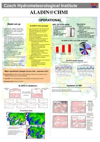
CHMI status report. ALADIN/CE configuration. LACE domain (309x277 grid points, linear truncation E159x143, Δx=9km) 43 vertical levels, mean orography time step 360 s

E N D
ALADIN/CE configuration • LACE domain (309x277 grid points,linear truncation E159x143, Δx=9km) • 43 vertical levels, mean orography • time step 360 s • digital filter spectral blending longcut-off cycle (6h cycle, filtering at truncation E47x42, no DFI in the next +6h guess integration) • digital filter blending + incremental DFI initialization of short cut-offproduction analysis
ALADIN/CE configuration • 3h coupling interval • ARPEGE/ALADIN cycle 28T3 • 00 and 12 UTC forecast to +54h • 06 and 18 UTC forecast to +24h • hourly on-line fullpos • post-processing of near-surface parameters into selected localitiesusing obs-operators of OI
Other tools • hourly DIAGPACK analysis of T2m, RH2m, v10m, KO-index, CAPE, MOCON (SYNOP observations) • verification package based on cycle AL12 (AL28 in validation) • monitoring of SYNOP and TEMP observation based on OI quality control
archiving HPCF NEC SX6/4B-32 data handling system Sun Fire 4810 Sun StorEdge 9910 archive server Sun E250 Qualstar TLS 58264 computing SAN 1 Gb Ethernet suite control & products 100 Mb Ethernet Internet 2 Mbps RMDCN WAN Sun cluster Linux cluster MSS dissemination Computational facilities
Mediterranean Forecasting SystemToward Environmental Predictions NEW DOMAIN • 589x309 grid points → 256x200 grid points • 299x159 linear truncation → 127x99 linear truncation • 9.5 km resolution • 37 levels
Future plans and planned changes OI surface analysis based on SYNOP data replacing the surface blending Interactive computation of mixing length based on PBL diagnostics after Ayotte and Tudor temperature RMSE relative humidity RMSE