Download
1 / 58
580 likes | 683 Views
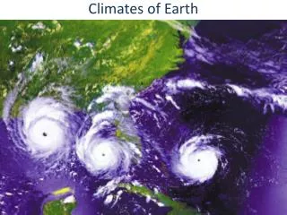
Mr. Marston Geography 9th grade DCHS Marietta, GA. Climates of the Earth. Weather. Climate:. Condition in the atmosphere in one place during a limited period of time. It’s the day to day temperature and precipitation.

E N D
Mr. Marston Geography 9th grade DCHS Marietta, GA Climates of the Earth
Weather Climate: • Condition in the atmosphere in one place during a limited period of time. It’s the day to day temperature and precipitation. Common types of weather are wind, clouds, rain, snow, fog, and dust storms. Less Common events are tornadoes, hurricanes, and ice storms. • Term for the weather patterns that an area typically experiences over a period of time. The standard averaging period is 30 years. (Temperatures, humidity, atmospheric pressure, winds, and rainfall) Weather vs. Climate
Earth’s Tilt and Rotation • Earth is closest to the sun in January (91,405,000) miles and farthest from the sun in July (94, 511,000) miles. • Seasons are determined by the tilt of the earth and not the Earth’s proximity to the sun. • Earth’s axis is tilted at 23.5 degrees, which affects temperature. • One complete rotation every 24 hours, from west to east, about 1,000 miles per hour. Rotation gives us night and day. • Revolution: one trip around the sun takes 365 days plus a few hours.
The shape of Earth’s orbit becomes more or less oval (eccentricity) • Earth wobbles as it spins (precession) • Earth's axis changes too (tilt). • All these changes, over thousands of years, causes Earth's climate to change. Changes in Earth’s Orbit causes climate to change
Changing intensity and changing amount of sunlight to the different hemispheres gives rise to the seasons of summer, fall, winter, and spring. • Summer solstice: In the northern hemisphere, around June 21. Marks the point at which the north pole of the earth is tilted at its maximum towards the sun. Longest day of the year in the northern hemisphere. Marks the beginning of the winter for the southern hemisphere. • Winter Solstice: first day of winter for the northern hemisphere, around December 21st. The day the north pole of the earth is tilted at its maximum away from the Sun. Shortest day of the year in the northern hemisphere. • Autumnal Equinox: Beginning of fall in the northern hemisphere, around September 23rd. • Vernal Equinox: Beginning of spring in the northern hemisphere, around March 21st. • Equinox: “Equal night.” Neither the north pole nor the south pole is inclined towards the sun. On the vernal and autumnal equinoxes, day and night are about the same length all over the world. Seasons
http://www.windows.ucar.edu/tour/link=/the_universe/uts/images/seasons_big_gif_image.html Climatic ChANGE
Land of the Midnight Sun • “Yesterday, I played golf at 11:30p.m, and the day before I went for a long walk at 2am. It doesn’t matter what time it is, and I need less sleep.” Visitor to Norway North Pole: sun doesn’t set from March 20 to Sept. 23rd. South Pole: Sept. 23 to March 20. One pole is tilted towards the sun and receives continuous sunlight while the other pole is tilted away. Arctic Cathedral in Norway Midnight sun at Nordkapp, Norway
Greenhouse effect • Atmosphere traps sun to warm the planet • If too much heat escapes, plants will freeze. If too hot, the plants will die. • Conditions in the atmosphere must be regulated.
http://www.knowledge.firemansfund.com/pdf/graphics/what_is_global_warming.pdfhttp://www.knowledge.firemansfund.com/pdf/graphics/what_is_global_warming.pdf http://hyperphysics.phy-astr.gsu.edu/hbase/thermo/grnhse.html#c4 Useful websites on Global Warming
The view of most climate scientists is that rising CO2 in the atmosphere, primarily from human activity, is driving the current increase in global temperature. Climate modeling is very complex, the stakes are very high, and there are numerous special interests. Skeptical views on CO2 global warming The CO2 is not sufficient to drive the currently observed warming. The atmospheric CO2 level has been up to 10 times higher in the past. Why weren't there catastrophic consequences then? Much of this century’s temperature rise was in early years when industrial emissions were small, and there was a temperature decrease during the postwar economic boom. Ice core records show CO2 rises lagging temperature rises rather than driving them. Surface warming is more than atmospheric warming, in contrast to CO2-driven models. The global temperature of the past century correlates more strongly with solar activity than with CO2. The sunspot activity of our Sun and the associated magnetic fields divert some of the cosmic rays that nucleate clouds on the Earth. Skeptical views of Global Warming
Factors Affecting Climate: Latitudes • Low Latitudes: between the Tropics, which includes the Equator • Receives direct sun year round • Warm to hot climates • Mid Latitudes: area north of the Tropic of Cancer to the Arctic Circle and area south of the Tropic of Capricorn to the Antarctic Circle. • Temperate climate • Ranges from fairly hot to fairly cold • Experiences seasonal weather changes • High Latitudes: area near the north and south poles. One pole receives continuous sunlight depending on season.
Factors Affecting Climate: Elevation • Relationship between elevation and temperature • An elevation increases, temperatures decreased by about 3.5 degrees per 1,000 feet • Sunlight is brighter in higher elevations because the thinner atmosphere filters fewer rays of the sun. • Picture of Quito, Ecuador
Ocean Currents • Warm ocean currents are corridors of warm water moving from the tropics to the poles where they release energy to the air. • Cold ocean currents are corridors of cold water moving from higher latitudes toward the equator. They absorb energy received in the tropics thus cooling the air above.
Wind Zones • The wind zones are created by the heating (and rising) and cooling (and sinking) of air masses at the equator and the poles. • Pressure systems produced by the rising and sinking of air masses lead to wind zones. The circulation of our atmosphere is complicated by the Earth's rotation and tilt. The Earth's axis is tilted 23.5° from being perpendicular to the elliptical plane, the plane of its orbit around the sun. The tilt of the axis allows unequal heating of the Earth's surface, causing wind. • Air warmed by the Sun rises at the Equator, cools as it moves toward the poles, descends as cold air over the poles, and warms again as it moves over the surface of the Earth toward the Equator. This simple pattern of atmospheric convection is complicated by the rotation of the Earth, which introduces the Coriolis Effect. Thus, a wind traveling north from the equator will maintain the sideways velocity acquired at the equator while the Earth under it is moving sideways slower. This effect accounts for the winds turning toward the right as it moves northward across the Earth's surface. • Winds blow between areas of different atmospheric pressures, from high pressure areas to low pressure areas. The Coriolis Effect also causes these winds to turn right in the Northern Hemisphere, and left in the Southern hemisphere. In the zone between about 30° N. and 30° S., the surface air flows toward the Equator, called the trade winds.
A low-pressure nearly windless zone at the Equator is known as the doldrums. Around 30° N. and S., the air flowing towards the poles in the upper atmosphere begins to descend toward the surface in high-pressure nearly windless belts. The sinking air is relatively dry because its moisture has already been released as it rose, cooled, and condensed above the Equator, creating the tropical rain forests. This high-pressure nearly windless zone of descending air is called the Horse Latitudes. The name for this area is believed to have been given by sailors, whose ships stalled at these latitudes while crossing the oceans (with horses as cargo), and were forced to throw a few horses overboard to conserve water. The surface air that flows from these subtropical high–pressure belts toward the Equator is deflected toward the west by the Coriolis Effect. Because winds are named for the direction from which the wind is blowing, the trade winds are called easterlies. The trade winds meet at the doldrums. Surface winds known as prevailing westerlies flow from the Horse Latitudes toward the poles. This is our wind zone, so most of our weather comes from the west, specifically from the southwest to the northeast. The "westerlies" meet "easterlies" from the polar regions at about 50–60° N. and S, causing a windless zone called the subpolar lows. Since surface winds “drive” the ocean currents, both air and water circulation are controlled by all these factors. Wind Zones II
Wind Zones iii • Low Pressure: created when warm air from the equator heats and rises and becomes lighter than the surrounding air. • High Pressure: created in cooler areas when air sinks because it is heavier. • Winds will blow as air is squashed out by the sinking cold air and drawn in under the rising warm air. • Any difference in temperature will create a difference in air pressure resulting in winds that will blow. • Winds blow from high pressure to low pressure.
Wind Zones IV Vocabulary Recap • Doldrums: Windless zone at the equator caused by warm rising air. • Horse Latitudes: Subtropical high, windless zones caused by sinking air at 30 degrees north and south of the equator. • Subpolar low: windless zones produced when the winds of the polar easterlies and prevailing westerlies meet, leading to an upward motion of the air at approximately 60 degrees north and south of the equator. • Polar Highs: windless zone produced by sinking air above both poles. • Trade Winds: easterly horizontal surface winds that move between the horse latitudes and the subpolar lows. • Prevailing westerlies: westerly horizontal surface winds that move between the subpolar lows and the poles. • Polar easterlies: easterly horizontal surface winds that move between the subpolar lows and the poles. • Jet Stream: area of swiftly flowing upper libel winds located at the convergence of the main wind belts. Flows in a west to east direction at speeds exceeding 200 mph and heights of 5-7 miles. • Coriolis Effect: turning of moving bodies due to the rotation of the earth on its axis. Turns to the right in the northern hemisphere and to the left in the southern hemisphere.
Factors affecting Climate: ocean Currents • http://www.atmo.arizona.edu/products/wximagery/globalir.html
El Nino • El Nino is a temporary change in the climate of the Pacific ocean, in the region around the equator. • Causes: Winds that push water from east to west along the equator in the Pacific have weakened. In normal weather patterns, strong winds blow from east to west that piles up water in the western Pacific, which allows deeper cold water in the east to replace the warmer water that had been pulled to the west. Normal situation is warm water in the west and cold water in the east. However, El Nino doesn’t allow this temperature difference to occur so warm water in the west falls back to the east and not enough cold water gets pulled up. • Result: warmer ocean affects the winds and makes them weaker, then the winds get weaker and the ocean gets warmer, and so on. • Effect: wet winters in SE US. Wet weather along the coasts of North and South America, Drought in Indonesia and Australia. • Duration: one year or more. • Often: about one every three to seven years.
LA Nina: Opposite of El Nino • Cold temperatures in the Pacific. • Cold water and strong winds push more water than normal to the western Pacific. • Result: Very wet in Se Asia and Australia, mild winter in SE US and cooler in NW US.
Rain Shadow • Area of dry land that lies on the leeward (downside) of a mountain. • Winds carry air masses up and over the mountain range and as the air is driven upward over the mountain, falling temperatures cause the air to lose much of its moisture as precipitation. • Upon reaching the leeward side of the mountain, the dry air descends and picks up any available moisture from the landscape below. • Result: Rainfall and moist air prevails on the windward side of a mountain range while arid, moisture-poor air prevails on the leeward side of the mountain range. • Examples of dry, rain shadow regions and the mountain ranges that shield them: • The Gobi Desert lies in the rain shadow of the Himalayas. • The Atacama Desert lies in the rain shadow of the Andes • The Patagonia region lies in the rain shadow of the Andes. • Death Valley lies in the rain shadow of the Pacific Coast Ranges of California and the Sierra Nevada Mountains • Spokane, Washington lies in the rain shadow of the Cascade Mountain Range while Seattle, Washington lies on the windward side of the Cascades.
Types of Clouds • Clouds are visible accumulations of water droplets or solid ice crystals that float in the Earth's troposphere. • How Clouds Form: Clouds form when water vapor (water that has evaporated from the surface of the Earth) condenses (turns into liquid water or solid ice) onto microscopic dust particles (or other tiny particles) floating in the air. This condensation (cloud formation) happens when warm and cold air meet, when warm air rises up the side of a mountain and cools as it rises, and when warm air flows over a colder area, like a cool body of water. This occurs because cool air can hold less water vapor than warm air, and excess water condenses into either liquid or ice.
Prefixes and Suffixes Used to Describe Clouds:Clouds are defined by both the way they look and how high they are in the atmosphere. For example, cirro (meaning "wisp of hair") is a prefix given to high-altitude clouds (above 20,000 feet). Alto (meaning "high") is a prefix given to mid-altitude clouds (between 6,000 and 20,000 feet). There is no prefix for low-altitude clouds. When clouds are by the ground we call them fog. Nimbo (meaning "rain") as a prefix, or nimbus added as a suffix, in a cloud name indicates that the cloud can produce precipitation (rain, snow, or other forms of falling water). Cumulo (meaning "heap") refers to piled-up clouds. Strato (meaning "layer") refers to flat, wide, layered clouds.
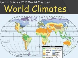
World Climate Patterns • 1. Tropical • 2. Dry • 3. Mid Latitude • 4. High Latitude • 5. Highlands • 6. Permafrost
Tropical Climate Tropical climates are located near the Tropics of Capricorn, Tropic of Cancer and the Equator 1A. Tropical Rain Forest Average temperature of 80 degrees Warm, humid air is saturated with moisture, produces daily rain Yearly rainfall averages about 80 inches 1B. Tropical Savannahs Dry winters and wet summers In summer, ground is covered with clumps of coarse grass Found in Africa, Central and South America, Asia, and Australia
Despite covering only 2% of our planet's surface, over half of the earth's animal, insect species, and flora live there. • Amazon rain forests produce about 40% of the world's oxygen • One in four pharmaceuticals comes from a plant in the tropical rain forests • 1400 rain forest plants are believed to offer cures for cancer • 40% of tropical rain forests have already been lost in Latin America and Southeast Asia • Within a four mile square area of a tropical rain forest, you would find: • Over 750 species of trees • 1500 different kinds of flowering plants • 125 species of mammals • 400 species of birds • 100 reptiles • 60 amphibians • countless insects • 150 species of butterflies • **Only 1% of these species has ever been studied** • The Rainy Tropics (Rain Forest) Breakdown: • Have no winter • Broad leaf evergreens, sparsely vegetated floor • High diversity rates of plant and animal life • Mostly subsistence farming, slash and burn or shifting agriculture • Main food types: bananas, plaintan, cassava, taro, coconuts • Commercial crops: mango, papaya, banana, latex, cacao (chocolate bean), oil palm Other commercial uses: fishing and timber; much land burned & cleared for livestock grazing Tropical Rain Forest
1B. Tropical SavannaH • Transition zone between wet rainfall tropics and arid lands of tropical deserts • Strong seasonal rhythms of rain and drought • Heaviest rains in the summer, dry a few months to ½ year • Savanna: Longer dry season than typical wet/dry monsoon (mostly in Africa) • Foods: corn, millet, sorghum, rice, sugarcane, pineapple, citrus Also: cotton and livestock ranching
2. Dry Climates • 2A. Desert: Dry areas with sparse plant life. • Rainfall less than 10 inches per year. • Daily temperatures vary widely from hot days to cool evenings. • About 1/3 of the earth’s surface is desert. • Natural vegetation consists of scattered scrub and cactus and plants that tolerate low humidity and wide temperature ranges. • Some deserts contain oases, areas of vegetation and sources of water. • 2B. Steppe: dry, treeless grasslands. • Annual rainfall between 10 and 20 inches per year. • Warm summers and cool winters • Formed between deserts and forests
2A. Desert Stuff • World's Largest Deserts • Sahara: 3,500,000 sq. miles North Africa • Gobi: 500,000 sq. miles. Mongolia-China • Kalahari: 225,000 sq. miles. Southern Africa. • Great Victoria: 150,000 sq. miles. Australia • Great Sandy: 150,000 sq. miles. Australia. GOBI DESERT in Mongolia/China
Desert • low relative humidity and cloud cover • low frequency and amount of precipitation • high average temperature • high wind velocities
2B. Steppes • Deep in continental interiors, far from oceanic sources of moisture • Many regions in rain shadows of high mountain ranges • Can extend over large latitude ranges • Winter temperatures mild, summers hot in low latitudes • Winters frigid and summers cooler at higher latitudes • Low precipitation, concentrated in summer • Prairies widespread in wetter parts; lush grasslands • Steppe: very short grasses, sparsely settled, mostly wide open spaces • Wheat grown in wetter areas, livestock grazing in drier ones • Prairie =Great Plains in US=Pamapas in Argentina=Grasslands of Central Asia; all refer to same climate/vegetation regime
3. Mid LaTitude Climates Mid latitude climates have variable weather patterns and changing seasons. A.Marine West Coast: NW US and Northern Europe, parts of South America, Africa, Australia and New Zealand. 1. cool summers and damp winters 2. coniferous trees: cones (evergreen trees) 3. Deciduous trees: broad leaves, change color and drop their leaves in autumn. 4. Mixed forest: contains both types of trees. B. Mediterranean: 1.Mild rainy winters and hot sunny summer 2. chaparral: thickets of woody bushes and short trees. 3. Southern California, parts of Southern Australia and Southern Europe C. Humid subtropical climate 1.short, mild winters and nearly year round rain. 2. High humidity levels 4. vegetation: prairies (inland grasslands) and mixed forest. D. Humid Continental Climate 1.Located in southern Canada, western Russia, and northeastern China 2. Longer severe winters and shorter and cooler summers
3A. Marine WestCoast • Reach further poleward than Humid Continental • But climates are milder than Humid Cont. at similar latitudes • Cyclonic westerlies and proximity to ocean influence precipitation regime--much wetter • Rainfall comes in fall/winter months • Temperate rainforest situation, has huge trees • Crops: fruit trees and year-round grazing situation ideal for dairy industry, also lots of sheep
3B.Mediterranean Climate • Hot/warm and dry summers, rainy winters • Food crops: wheat, olives, grapes, citrus, lavender • Also: sheep and goats which are herded on unsuitable rocky lands • Vegetation consists of many drought tolerant plants • Land forms: mountainous near the sea with some interior coastal plains and interior valleys • 1% of land area in this climate, 4% of world population--very popular place to live
3C.Humid SubTropical Climate • Eastern shores of continental land masses • Transition zone between tropics and harsher polar latitudes • Long summers, heaviest precipitation in summer • Several major world river systems fed by these regions • Forests predominate in mountains; wetland areas abound in lowlands; flat to gently rolling land under cultivation • Major crops: cotton, pasture for cattle in US, rice in East Asia, livestock in South America and Australia • Region of major urban industrialization • You are currently in this climate zone