Download
1 / 48
490 likes | 644 Views
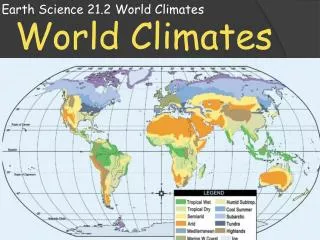
Climates of the Earth. Climograph. Graph that indicates average temperature and precipitation for a place. Line Graph shows temperature Bar Graph shows precipitation. If the line graph goes up in the middle – it is showing a place in the northern hemisphere.

E N D
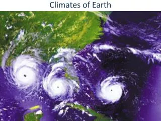
Climates of the Earth
Climograph • Graph that indicates average temperature and precipitation for a place. • Line Graphshows temperature • Bar Graphshows precipitation If the line graph goes up in the middle – it is showing a place in the northern hemisphere. If the line graph goes down in the middle – it is showing a place in the southern hemisphere. If the line is fairly straight – it is showing a place that is near or on the Equator.
Low Latitude Climates "The Tropics" 0 - 23.5 N & S 1. Tropical Rainforest 2. Tropical Savanna
Tropical Rainforest • Description – hot and wet throughout the year. • Precipitation Wet – 80 + inches a year - Rains daily • Temperatures about 80 all year • vegetation - Lush and diverse – 6% of earth, but more than half the plant and animal species. Canopy – layers of broadleaf evergreen trees.Leaching – continuous rain pulls the nutrients out of the soil (not arable) Amazon River Basin Congo River Basin Indonesia
Rio Temperatures are about even so it must be near the Equator. Belem Tons of precipitation every month. Hot and wet throughout the year
Tropical Savanna • Description – grassland withdistinct dry and wet seasons. Winter is dry. • Summers have 20 – 100 inches of precipitation a year. Winter is dry. Dry season is dramatic. • High year round temperatures around 80. • Vegetation – clumps of coarse grass and few trees. • Llanos of Venezuela • Caribbean Islands • Serengeti of Tanzania
COLD COLD DRY DRY Darwin Dakar Near the Equator Very obvious dry season in winter
Dry and Semi-Arid Climates low and mid-latitudes 0 - 66.5 N & S 1. Steppe 2. Desert
Steppe • Description – dry, largely treeless grassland. • Location – Low & mid latitudes. Border deserts & interior of continents (leeward side) • Precipitation 10 – 20 inches a year • Vegetation - Grassland with few trees or cactus. Desertification - spread of desert-like conditions to semi-arid areas is a serious problem in the Steppe Central Asia Western US Mountains Sahel - South of Sahara
Alice Spring Northern Southern Hemisphere Hemisphere add up the precipitation - 10 - 20 inches
Description – dry area with sparse plant life that covers about 1/3 of the world’s land. There are two types of terrain: reg – desert pavement (gravel, rocks, and sand) and erg – dunes • Precipitation – 10 in. or less a year • Temperatures: Desert does not mean hot – it means dry!!! Day and night temperatures vary drastically. • Vegetation - scrub and cactus Oasis is an area in the desert where water is available. Desert Sahara Great Basin Gobi
Cairo Tehran Desert does not mean hot less than 10 inches a year Lima
Middle Latitude Climates "Temperate Zone" 23.5 to 66.5 N & S 1. Marine 2. Mediterranean 3. Humid Subtropical 4. Humid Continental
Marine (Marine West Coast) • Description –ocean winds bring cool summers and damp winters. • Location – 30-60º on the west coast in N. Hemisphere and east coast in S. Hemisphere. Located on Westerlies. • Precipitation: Ocean air brings abundant rainfall. • Vegetation: large coniferous – evergreen forests called temperate rainforests and mixed forests - both coniferous and deciduous trees. Coastal Oregon to Southern Alaska Ireland Southeastern New Zealand
London Vancouver Sydney Abundant rainfall all year. High around 70. Low around 40.
Mediterranean • Description – mild, rainy winter and hot sunny summers. • Precipitation: 15 – 30 in (mostly in the winter) • Vegetation - Chaparral – underbrush, woody bushes and short trees – cork, olives, grapes, etc. Leathery leaves hold moisture Mediterranean Southern California Southern Australia
COLD COLD WET WET Perth Precipitation in winter months Athens Jordan Santiago COLD COLD WET WET
Humid Subtropical • Description – short, mild winters and nearly year round rainfall. hurricanes & typhoons. • HOUSTON is in HST • Precipitation: year round • Vegetation – fruits, rice, vegetables, inland grasslands, and mixed forests - deciduous and coniferous trees. Southeastern China Southeastern USA Tip of South Africa
Buenos Aires Shanghai Southern hemisphere Northern hemisphere rainfall all year (more in summer) Temps - 80 high / around 45 low
Humid Continental • Description -4 distinct seasons. Storms and continentality - far in the interior of continents influence climate. • Location -interior mid-latitude in N. Hemisphere • Temperatures: winters longer as you travel north and inland. • Vegetation: Agriculture has replaced natural prairie grass, and short coniferous forests. S. Canada & N. US Western Russia NE China
Moscow Helsinki Northern Hemisphere precipitation all year 60 high. 20 low.
High Latitude Climates "Polar Climates" 66.5 - 90 N & S Subarctic Tundra Icecap
Subarctic • Description – bitterly cold winter and short, cool summers. • Temperatures: Widest temperature range between summer and winter. • Vegetation: Taiga (Russian word for forest) a boreal forest – needled evergreens. • Permafrost – only a small layer of the ground thaws. Siberia Inland Canada Northern Scandinavia
Omsk Saskatoon Northern Hemisphere a little precipitation all year 70 high. Some months below freezing. widest temperature range.
Tundra • Description – very cold with polar night for ½ of the year. • Location – far north in the northern hemisphere • Temperature: Cold: rarely above 50° - at least 9 months below freezing – some below 0º • Vegetation: Short bushes, short grass, mosses, and lichen. permafrost bogs in summer. Coastal Greenland Peninsular Antarctica Arctic border lands
Freezing Freezing Northern Hemisphere very little precipitation all year High around 50. Many months below freezing.
Description – snow and ice cover this area up to 2 miles thick • Polar night – 6 months a year the sun does not rise above the horizon (24 hours dark) • Polar desert – moisture in the air does not reach the dew point, so it does not precipitate. Far away from Equator (dry & cold as move away) • Temperature: Below freezing all year - Many months below zero. • Vegetation: Possibly lichen and moss Icecap Interior Greenland Arctic Ocean Antarctica
Freezing Freezing Thuls Air Force Base Northern Southern Hemisphere Hemisphere Dry. No months above freezing.
Highland Climates • Located in mountain systems throughout the world • Precipitation – affected by the Orographic Effect. Leeward is dry – windward is wet. • Temperature – varies with elevation – for every 1,000 feet increase in elevation the temperature decreases 3.5 • Vegetation – usually mixed forests at the base. Meadows with small trees, shrubs, and wildflowers line the mountainsides. Himalaya Mts. Andes Mts. Zagros Mts.+
Northern Hemisphere Near Equator Near Equator All of these locations are over 4,000 ft. Mexico City
Vertical Climate of Latin America Tierra Caliente Tierra Templada Tierra Fria Paramo Tierra Helada
Hot land. • 0 - 2,500 ft. • 68-91ºF. • Grow: rice, Banana, sugar cane, cacao, pineapple • Forests: Sea level – swamps up to dry forests around 2,000 feet Tierra Caliente
Temperate land. • 2,500 – 6,500 ft. • 60-70ºF. • Grow coffee, cotton, tobacco, citrus fruit, squash, beans, and corn • Forests: Wet forest Tierra Templada
Tierra Fria • Cold land. • 6,500 – 10,000 ft. • Less than 60 degrees. • Grow grains such as wheat, oats, rye, and barley, apples, and also potatoes. • Forests: Cloud forests
Paramo • Most above the tree line. • 10,000 – 14,000 feet • temperatures: 20 – 55º • Grow: Grassland and hardy shrubs. • Elfin forest at lowest elevations • Grazing of sheep, alpacas, and llamas.
Snow line and above. • Above 14,000 feet • Below 20º. • Nothing grows here except maybe a few moss and lichen in summer. Tierra Helada