Download
1 / 26
340 likes | 958 Views
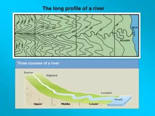
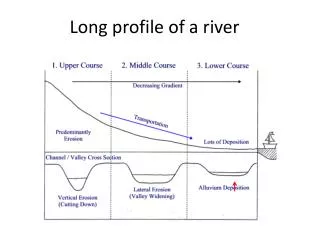
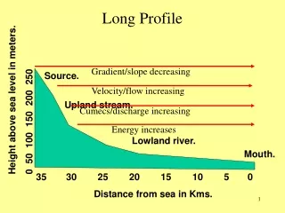
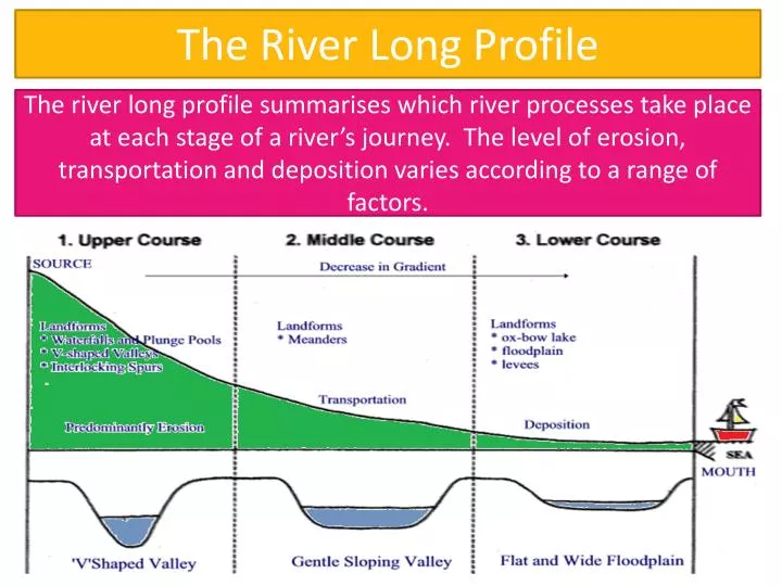
The river long profile summarises which river processes take place at each stage of a river’s journey. The level of erosion, transportation and deposition varies according to a range of factors. . The River Long Profile. Do you know the difference between erosion and transport?.

E N D
The river long profile summarises which river processes take place at each stage of a river’s journey. The level of erosion, transportation and deposition varies according to a range of factors. The River Long Profile
Use P. 9 if you’re unsure • How might the following affect the rate of erosion… • Gradient (angle of slope) • Rock type • Bedload (the amount of material being carried) • Human factors
Landforms in the Upper Course Pt 1 LO: To describe two landforms that form in a river’s upper course. All will be able to describe, using a diagram, how v shaped valleys and waterfalls form Most will be able to explain how the landforms can develop further Some will be able to use at least 3 key terms in their explanation of formation
Interlocking spurs Near their source, rivers tend to follow a fairly straight path but as they move further from the source they start to wiggle around obstructions this creates areas that point into the river called spurs. Where these points mesh in together they are called interlocking spurs. 3. How do v shaped valleys lead to the formation of interlocking spurs? http://www.cleo.net.uk/resources/displayframe.php?src=308/consultants_resources%2F_files%2Fintespur2.swf
Landforms in the Upper Course Pt 2 All will be able to describe, using a diagram, how v shaped valleys and waterfalls form Most will be able to explain how the landforms can develop further Some will be able to use at least 3 key terms in their explanation of formation LO: To describe two landforms that form in a river’s upper course.
Every second, more than 2 million litres of water plunges over the Horseshoe Falls segment of Niagara Falls creating one of the world's largest waterfalls as well as eating away as much as two meters of rock per year.
The waterfall retreats back forming a gorge (steep sided valley) Overhang becomes unsupported and falls into the plunge pool
Where does the water come from? The Great Lakes. The Niagara River that flows over the falls is 58km long and links Lakes Erie and Ontario How is the water used? The waters of the Niagara River are used by 100,000+ Canadians and US citizens for a range of purposes such as: drinking, boating, fishing, swimming, birdwatching, Industrial cooling, and hydroelectricity What is the future of the falls? The falls keeps on moving back. The Niagara Gorge extends from the Falls for 11 kilometres (7 mi.) Erosion is due to freeze thaw in winter, solution from the spray itself, and abrasion of the shalesby fallen limestone boulders. 50,000 years from now, at the present rate of erosion, the falls will have moved back as far as Lake Erie so there won’t be a falls anymore.
True or False 1. The plunge pool is located at the top of the waterfall. • There are 2 layers of rock involved in the formation • Niagara falls is located on the border of Canada and the USA. • The water plunges down a 50m cliff at Niagara Falls • The soft rock is located on top of the Whinstone rock • Waterfalls can be used for hydroelectric power
Niagara Falls, New York State USA / Ontario Canada CASE STUDY: A landform formed by water action that attracts people Name a landform formed by water that attracts people. Describe what attracts people to the landform. Explain how people’s use of the landform brings advantages
Describe what attracts people to the landform. • Often shown in films e.g. Niagara 1953, Superman II 1980, Pirates of the Caribbean – At World’s End 2006 • Close to major populations with great transport • Use for hydroelectricity • Lots of attractions – Maid of the Mist, nightly illuminations, winter light festival, journey behind the falls, the aero cable car, speed boat down the gorge, regular stunts etc. http://www.niagarafallslive.com/daredevils_of_niagara_falls.htm http://www.youtube.com/watch?v=A5ggG8PP7_U&safe=active
Explain how people’s use of the landform brings advantages The big benefit is money. Niagara Falls tourist industry serves approximately 28 million visitors each year. The hydroelectric plant not only supplies 4.4 gig watts of energy cleanly, the plants also lead to a contract being drawn up which guarantees to protect the falls and keep them flowing and clean.