Download
1 / 26
260 likes | 372 Views
Tom Piechota (UNLV) Kenneth Lamb (UNLV) Glenn Tootle (University of Tennessee) Tyrel Soukup (University of Tennessee) Oubeid Aziz (University of Tennessee). Colorado River Basin Long Lead Forecasting Research . U.S. Bureau of Reclamation National Oceanic and Atmospheric Administration

E N D
Tom Piechota (UNLV) Kenneth Lamb (UNLV) Glenn Tootle (University of Tennessee) TyrelSoukup(University of Tennessee) Oubeid Aziz (University of Tennessee) Colorado River Basin Long Lead Forecasting Research U.S. Bureau of Reclamation National Oceanic and Atmospheric Administration National Science Foundation Wyoming Water Development Commission
Tootle, G.A., A.K. Singh, T.C. Piechota and I. Farnham, 2007. Long Lead-Time Forecasting of U.S. Streamflow Using Partial Least Squares Regression. ASCE Journal of Hydrologic Engineering, 12(5), 442-451. Soukup, T., O.A. Aziz, G.A. Tootle, S. Wulff and T. Piechota, 2009. Long-lead Time Streamflow Forecasting of the North Platte River Incorporating Oceanic-Atmospheric Climate Variability. Journal of Hydrology, 368(2009), 131-142. Aziz, O.A., G.A. Tootle, S.T. Gray and T.C. Piechota, 2010. Identification of Pacific Ocean Sea Surface Temperatures influences of Upper Colorado River Basin Snowpack. Water Resources Research, 46, W07536. Lamb, K., T. Piechota, O. Aziz, G. Tootle, 2011. Establishing A Basis For Extending Long-Term Streamflow Forecasts In The Colorado River Basin. ASCE Journal of Hydrologic Engineering (In Press). Recent Publications
Long Lead-Time Forecasting of U.S. Streamflow Using Partial Least Squares Regression (Journal of Hydrologic Engineering, 2007) • Data Sets • - Pacific & Atlantic Ocean Sea Surface Temperatures (SSTs) • 1950 -2001 • April – September of previous year (-) • - Continental U.S. streamflow from USGS Unimpaired data (1950 – 2002) • 1951 – 2002 • Water year volume • Methods • - Partial Least Squares Regression (PLSR) • - Based on optimized Principal Component Regression of two fields (SSTs and streamflow) • Contributions • - Skillful long lead-time forecast of continental U.S. streamflow using SSTs • - Calibration, Cross-validation and Uncertainty in model development
Upper Colorado River Basin (White River) PLSR Calibration Model Results (Leading April – September SSTs, Water Year Streamflow) Pacific Ocean SSTs Streamflow Stations (R2 > 0.80) Atlantic Ocean SSTs Streamflow Stations (R2 > 0.80)
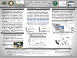
Long Lead-Time Streamflow Forecasting of the North Platte River Incorporating Oceanic-Atmospheric Climate Variability (Journal of Hydrology, 2009) • Data Sets • - Pacific Ocean Sea Surface Temperatures (SSTs) and 500 mbgeopotential heights • 1948 -2006 • July - September of previous year (-) • - North Platte River streamflow • 1948 – 2006 • April – July volume • Methods • - Singular Value Decomposition for diagnostics • - Non parametric exceedanceprobablity forecasts (Piechota et al., 2001)
Results SSTs Figure 2: Heterogeneous correlation map showing significant SST regions as related to NPRB streamflow stations for JAS(-1) six month lead-time. Z500 Figure 4: Heterogeneous correlation map showing significant Z500 regions as related to NPRB streamflow stations for OND(-1) three month lead-time.
Streamflow Forecast Example Example: 20% chance (80% risk) of exceeding 190,000 acre-feet (Average monthly volume summed for the 4 months of interest) Research Question #3
Upper Colorado River Basin (UT, CO) Snowpack ? Aziz et al. (2010) McCabe and Dettinger (2002)
0 – 2 Year Forecasting of Colorado RiverWater Volume Prepared by Kenneth Lamb, Tom Piechota, Simon Wang, Sajjad Ahmad, AJ Kahlra 14
Statistical Forecast Model • Support Vector Machine (SVM) • Neural Network – Statistical Learning Model • Inputs: Calendar year mean SOI, PDO, NAO, AMO • Predictand: Following year precipitation • Performance Measure: RMSE Standard Ratio of Deviation (RSR)
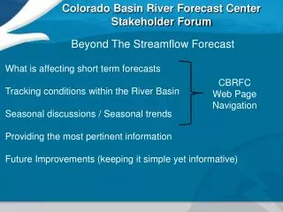
L Ocean-Atmosphere-Streamflow • During the winter months …
SVD/Correlation Results Simultaneous Year 1 Year Lag 2 Year Lag 3 Year Lag 500mb Geopotential Height 200mb Zonal Wind
Forecast Method • Weighted Resampling of Observed Naturalized Streamflow • Split sample forecast verification alternatives • 1st ~ 1976-2005 used to forecast 1906-1975 • 2nd ~1956-2005 used to forecast 1906-1955 • 3rd ~ 1906-1945 used to forecast 1956-2005 • Weight based upon 3-month avg. SST of Hondo region
Forecast Skill Maps – LEPS 0 Lag 1-yr Lag 2-yr Lag Alternative 1 Alternative 2 Alternative 3
Identifying Climate Cycles • 10-20 year cycle in data • PDO leads precipitation by 3 years • SST cycle highly correlated with Nino4 region References: Wang et al, 2009; Wang et al 2010a.
Pacific Ocean – Precipitation Lag Figure 2 - Wang et al (2010a). A transition-phase Teleconnection of the Pacific Quasi-Decadal Oscillation. Clim Dyn DOI 10.10007/s00382-009-0722-5.
L Ocean-Atmosphere-Streamflow • Another physical basis for long-lead forecasting NINO 4