1 / 12

nws.noaa/mdl/etsurge/index.htm?coast=me&stn=mdann&type=both

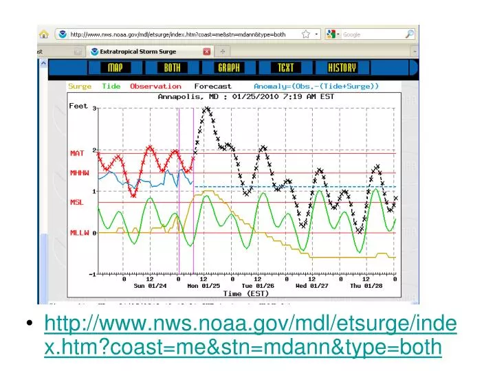
http://www.nws.noaa.gov/mdl/etsurge/index.htm?coast=me&stn=mdann&type=both. Ernesto Isabel Fran. Flooding LIDAR DEM. Isabel 2.0 m Fran 1.2 m Ernesto 0.85 m. Isabel, 2 m above NAVD. Fran, 1.2 m above NAVD. Ernesto, 0.9 m above NAVD.

kareem
Download Presentation

nws.noaa/mdl/etsurge/index.htm?coast=me&stn=mdann&type=both

An Image/Link below is provided (as is) to download presentation Download Policy: Content on the Website is provided to you AS IS for your information and personal use and may not be sold / licensed / shared on other websites without getting consent from its author. Content is provided to you AS IS for your information and personal use only. Download presentation by click this link. While downloading, if for some reason you are not able to download a presentation, the publisher may have deleted the file from their server. During download, if you can't get a presentation, the file might be deleted by the publisher.

E N D

Presentation Transcript


  1. http://www.nws.noaa.gov/mdl/etsurge/index.htm?coast=me&stn=mdann&type=bothhttp://www.nws.noaa.gov/mdl/etsurge/index.htm?coast=me&stn=mdann&type=both

  2. ErnestoIsabelFran

  3. Flooding LIDAR DEM Isabel 2.0 m Fran 1.2 m Ernesto 0.85 m

  4. Isabel, 2 m above NAVD

  5. Fran, 1.2 m above NAVD

  6. Ernesto, 0.9 m above NAVD

  7. Hurricane ERNESTO (24 AUG-01 SEP - 2006)Storm - Max Winds: 65 Min Pres: 987 Category: 1 Annapolis Flooding: 0.9 m above NAVD

  8. Hurricane FRAN (24 AUG-06 SEP - 1996)Storm - Max Winds: 100 Min Pres: 946 Category: 3 Annapolis Flooding: 1.2 m above NAVD

  9. Hurricane ISABEL (06-19 SEP - 2003)Storm - Max Winds: 140 Min Pres: 920 Category: 5 Annapolis Flooding: 2.0 m above NAVD

More Related