Download
1 / 24
240 likes | 322 Views
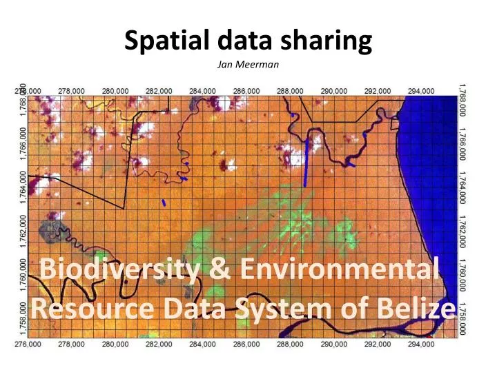
Spatial data sharing Jan Meerman. Biodiversity & Environmental Resource Data System of Belize. Since 2000 I have been incorporating GIS into my work routine. Just about anything has a spatial component. So:. Biodiversity Data.

E N D
Spatial data sharingJan Meerman Biodiversity & Environmental Resource Data System of Belize
Since 2000 I have been incorporating GIS into my work routine. Just about anything has a spatial component. So: • Biodiversity • Data
Since 2000 I have been incorporating GIS into my work routine. Just about anything has a spatial component. So: • Biodiversity • Data • Conservation zonation
Since 2000 I have been incorporating GIS into my work routine. Just about anything has a spatial component. So: • Biodiversity • Data • Conservation zonation • Protected Areas
Since 2000 I have been incorporating GIS into my work routine. Just about anything has a spatial component. So: • Biodiversity • Data • Conservation zonation • Protected Areas • Threat assessment
Since 2000 I have been incorporating GIS into my work routine. Just about anything has a spatial component. So: • Biodiversity • Data • Conservation zonation • Protected Areas • Threat assessment • Timber extraction
Since 2000 I have been incorporating GIS into my work routine. Just about anything has a spatial component. So: • Biodiversity • Data • Conservation zonation • Protected Areas • Threat assessment • Timber extraction • Long term logging licenses
Since 2000 I have been incorporating GIS into my work routine. Just about anything has a spatial component. So: • Biodiversity • Data • Conservation zonation • Protected Areas • Threat assessment • Timber extraction • Long term logging licenses • Hurricane damage
Since 2000 I have been incorporating GIS into my work routine. Just about anything has a spatial component. So: • Biodiversity • Data • Conservation zonation • Protected Areas • Threat assessment • Timber extraction • Long term logging licenses • Hurricane damage • Etcetera
Most will be familiar with the Belize Ecosystems Map First version published in 2001 With an update in 2005 Much of this work carried out as part of projects that require their output to be public domain. But how to disseminate and assure that people have access to latest version?
Biodiversity & Environmental Resource Data System of Belizehttp://www.biodiversity.bz
Biodiversity & Environmental Resource Data System of Belizehttp://www.biodiversity.bz
Biodiversity & Environmental Resource Data System of Belizehttp://www.biodiversity.bz
Biodiversity & Environmental Resource Data System of Belizehttp://www.biodiversity.bz
Biodiversity & Environmental Resource Data System of Belizehttp://www.biodiversity.bz Google Earth Protected Areas KML file
Biodiversity & Environmental Resource Data System of Belizehttp://www.biodiversity.bz
Biodiversity & Environmental Resource Data System of Belizehttp://www.biodiversity.bz
Biodiversity & Environmental Resource Data System of Belizehttp://www.biodiversity.bz
Biodiversity & Environmental Resource Data System of Belizehttp://www.biodiversity.bz
Biodiversity & Environmental Resource Data System of Belizehttp://www.biodiversity.bz
Biodiversity & Environmental Resource Data System of Belizehttp://www.biodiversity.bz All data posted must have metadata GIS data must also be accompanied by standard metadata like in ArcGIS
Biodiversity & Environmental Resource Data System of Belizehttp://www.biodiversity.bz All data posted must have metadata GIS data must also be accompanied by standard metadata such as FGDC metadata used in Arc View 3.x.Metadata Collection Tool V2 Developed by NOOA Coastal Services Center 1999.
Biodiversity & Environmental Resource Data System of Belizehttp://www.biodiversity.bz Apart from these standard tools I find it useful to provide metadata in standard MS-Word format. This can be useful to illustrate complex procedures
Biodiversity & Environmental Resource Data System of Belizehttp://www.biodiversity.bz Thank You!