Download
1 / 22
230 likes | 758 Views
Soil Survey Chapter 19. This short presentation focuses on the two below topics. A soil survey is an inventory of soils in a county. It shows where different soil types occur, gives properties of them and says whether their properties may limit uses of them.

E N D
Soil Survey Chapter 19
A soil survey is an inventory of soils in a county. It shows where different soil types occur, gives properties of them and says whether their properties may limit uses of them. This is one of two types of soil maps. It’s low resolution.
Thus, soils in an association may be fairly similar, like the loess soils on campus. The Feliciana is on the slopes and is better drained than Olivier, which is on broad flat areas.
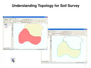
The other type of soil map is much higher resolution and shows what specific soil type is at a spot. The whole county is shown in aerial photos with soil type boundaries super- imposed. What’s in red is a square mile, or section of land (= 640 acres). The small letters inside boundaries are abbreviations for soil types (technically, mapping units).
This is your guide to which detailed map sheet (aerial photo) to see for a specific tract of land. It’s right before the aerial photos.
There are usually only a few dozen soil types in a county. The first task in making a soil survey is to determine what soil types occur. This is where an understanding of soil formation is very useful. If you have information on the geology of the county, you have a guide to parent material. Dig some exploratory holes on different combina- tions of parent material, vegetative cover and topographic position, and see what what’s there, i.e., soil type. A lot of lab work besides the detailed descriptions of typicalpedons for the different soil types in the county.
Auger a hole where you think a certain soil is and one where you think another one is. Guess and confirm location of transition along a transect. More efficient than grid sampling (compare number of holes in illustration).
Spectral data correlated with soil properties. Particularly helpful in difficult terrain.
Maps and tables are the core of a soil survey. However, explanations in narrative sections and definitions in glossary are necessary for the layman to fully understand tables.
The soil types delineated on aerial photos are called mapping units. Sometimes these are soil series or minor variations of a certain series called phases. This might have to do with texture (Ruston sandy loam or Ruston fine sandy loam), slope (Ruston, 1 – 3 %, or Ruston, 3 – 8 %) and so forth. In some cases, different soil types occur in such tight and complicated spatial patterns that it is not feasible to delineate them. There are 2 types of this kind of lumping, consociation, with 2+ soil types that are similar, and complex, with 2+ types that are dissimilar.
This is an important table for agricultural use of a soil. You can farm Class I soils without risking de- grading them. More management is needed with Class II, even more with III.
Lower case letter for Class II and up gives the major limitation. Erosion and wetness are common for soils in Louisiana. Wetness refers to a shallow water table.
These are estimates of relative productivity for possible crops and are part of the Land Capability Class table. Numbers are per acre. AUM = animal unit month, like 1 acre of bahiagrass can support 1 cow for 7 months or you need 12 / 7 acres per cow.
The next slide gives ratings for a few soils if used for camp sites or golfing. Ratings are based on several factors. You don’t get much bounce and roll on a fairway that is water- saturated 6” below the surface. Obviously, you don’t want a fairway to flood, ever.