Download
1 / 38
380 likes | 390 Views
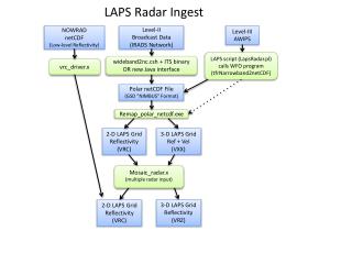
Steve Albers August 10, 2010. The Fusion of Radar Data and Satellite Imagery With Other Information in the LAPS Analyses. NOWRAD netCDF (Low-level Reflectivity). Level-II Broadcast Data (IRADS Network). Level-III AWIPS. LAPS script (LapsRadar.pl) calls WFO program (tfrNarrowband2netCDF).

E N D
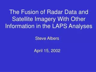
Steve Albers August 10, 2010 The Fusion of Radar Data and Satellite Imagery With Other Information in the LAPS Analyses
NOWRAD netCDF (Low-level Reflectivity) Level-II Broadcast Data (IRADS Network) Level-III AWIPS LAPS script (LapsRadar.pl) calls WFO program (tfrNarrowband2netCDF) GSD Central Facility Processing vrc_driver.x LAPS Radar Ingest Polar netCDF File (GSD “NIMBUS” Format) Remap_polar_netcdf.exe 2-D LAPS Grid Reflectivity (VRC) 3-D LAPS Grid Ref + Vel (VXX) Mosaic_radar.x (multiple radar input) 2-D LAPS Grid Reflectivity (VRC) 3-D LAPS Grid Reflectivity (VRZ)
Remapping Strategy • Polar to Cartesian • 2D or 3D result (narrowband / wideband) • Average Z,V of all gates directly illuminating each grid box • QC checks applied • Typically produces sparse arrays at this stage
Remapping Strategy (reflectivity) • Horizontal Analysis/Filter (Reflectivity) • Needed for medium/high resolutions (<5km) at distant ranges • Replace unilluminated points with average of immediate grid neighbors (from neighboring radials) • Equivalent to Barnes weighting at medium resolutions (~5km) • Extensible to Barnes for high resolutions (~1km) • QC check for fraction of gates with valid reflectivity in grid box • Vertical Gap Filling (Reflectivity) • Linear interpolation to fill gaps up to 2km • Fills in below radar horizon & visible echo
Horizontal Filter/Analysis(note different times) Without Filter With Filter
Mosaicing Strategy (reflectivity) • Nearest radar with valid data used • +/- 10 minute time window • Final 3D reflectivity field produced within cloud analysis • Wideband is combined with Level-III (NOWRAD/NEXRAD) • Non-radar data contributes vertical info with narrowband • QC checks • Minimum echo top height check • Maximum echo top temperature check • Consistency with satellite indicated clouds
LAPS cloud analysis METAR METAR METAR
Surface Precipitation Accumulation • Algorithm similar to NEXRAD PPS, but runs in Cartesian space • Rain / Liquid Equivalent • Z = 200 R ^ 1.6 • Snow case: use rain/snow ratio dependent on column maximum temperature • Checks on Z and T could be added to reduce bright band effect
Future Cloud / Radar analysis efforts • Account for evaporation of radar echoes in dry air • Sub-cloud base for NOWRAD • Below the radar horizon for full volume reflectivity • Processing of multiple radars and radar types • Evaluate Ground Clutter / AP rejection
Future Cloud/Radar analysis efforts (cont) • Consider Terrain Obstructions • Improve Z-R Relationship • Convective vs. Stratiform • Precipitation Analysis • Improve Sfc Precip coupling to 3D hydrometeors • Combine radar with other data sources • Model First Guess • Rain Gauges • Satellite Precip Estimates (e.g. GOES/TRMM)
Cloud/Satellite Analysis Topics • 11 micron IR • 3.9 micron data • Improving visible with terrain albedo database • CO2-Slicing method (Cloud-top pressure)
11 micron imagery • T(11u) best detects mid-high level clouds • Cloud Clearing Step • Cloud Building Step • Iterative Adjustment Step • Forward model converts cloud-sounding T(11u) estimate • Constrained 1DVAR iteration fits cloud layers to observed T(11u)
3.9 micron imagery • T(3.9u) – T(11u) detects stratus at night • Currently used with 11u cloud-tops for cloud building • Testing underway for cloud-clearing • Additional criteria include T(11u) and land fraction • T(3.9u) – T(11u) detects clouds in the daytime? • Visible may be similar in cloud masking properties • Visible may be easier for obtaining a cloud fraction • Cloud Phase? • Could work using T(3.9u) – T(11u) at night • Cloud-top phase needs blending throughout LWC/ICE column
Visible Satellite • Improving visible with terrain albedo database • Cloud-clearing (done with current analysis) • Cloud-building (now being tested) • Accurate sfc albedo can work with VIS + 11 micron cloud-tops • Visible cloud fraction can be used to correct apparent brightness temperature to yield improved cloud-top temperature
CO2 Slicing Method (cloud-top P) • Subset of NESDIS Cloud-Top Pressure data • CO2 measurements add value • 11u measurements (0 or 1 cloud fraction) redundant with imagery? • Imagery has better spatial and temporal resolution? • Treat as a “cloud sounding” similar to METARs and PIREPs
Selected references • Albers, S., 1995: The LAPS wind analysis. Wea. and Forecasting, 10, 342-352. • Albers, S., J. McGinley, D. Birkenheuer, and J. Smart, 1996: The Local Analysis and prediction System (LAPS): Analyses of clouds, precipitation and temperature. Wea. and Forecasting, 11, 273-287. • Birkenheuer, D., B.L. Shaw, S. Albers, E. Szoke, 2001: Evaluation of local-scale forecasts for severe weather of July 20, 2000. Preprints,14th Conf on Numerical Wea. Prediction, Ft. Lauderdale, FL, Amer. Meteor. Soc. • Cram, J.M.,Albers, S., and D. Devenyi, 1996: Application of a Two-Dimensional Variational Scheme to a Meso-beta scale wind analysis. Preprints, 15th Conf on Wea. Analysis and Forecasting, Norfolk, VA, Amer. Meteor. Soc. • McGinley, J., S. Albers, D. Birkenheuer, B. Shaw, and P. Schultz, 2000: The LAPS water in all phases analysis: the approach and impacts on numerical prediction. Presented at the 5th International Symposium on Tropospheric Profiling, Adelaide, Australia. • Schultz, P. and S. Albers, 2001: The use of three-dimensional analyses of cloud attributes for diabatic initialization of mesoscale models. Preprints,14th Conf on Numerical Wea. Prediction, Ft. Lauderdale, FL, Amer. Meteor. Soc.
Future LAPS analysis work • Surface obs QC • Operational use of Kalman filter (with time-space conversion) • Handling of surface stations with known bias • Improved use of radar data for AWIPS • Multiple radars • Wide-band full volume scans • Use of Doppler velocities • Obtain observation increments just outside of domain • Implies software restructuring • Add SST to surface analysis • Stability indices • Wet bulb zero, K index, total totals, Showalter, LCL (AWIPS) • LI/CAPE/CIN with different parcels in boundary layer • new (SPC) method for computing storm motions feeding to helicity determination • More-generalized vertical coordinate?
Recent analysis improvements • More generalized 2-D/3-D successive correction algorithm • Utilized on 3-D wind/temperature, most surface fields • Helps with clustered data having varying error characteristics • More efficient for numerous observations • Tested with SMS • Gridded analyses feed into variational balancing package • Cloud/Radar analysis • Mixture of 2D (NEXRAD/NOWRAD low-level) and 3D (wide-band volume radar) • Missing radar data vs “no echo” handling • Horizontal radar interpolation between radials • Improved use of model first guess RH &cloud liq/ice
Cloud type diagnosis Cloud type is derived as a function of temperature and stability