Download

1 / 18
180 likes | 552 Views
Physical features of Europe notes. SS6G8: The student will locate selected physical features of Europe. What are some uses of physical maps?. To show the physical features like various landforms and water bodies present on the earth’s surface.

E N D
Physical features of Europe notes SS6G8: The student will locate selected physical features of Europe
What are some uses of physical maps? • To show the physical features like various landforms and water bodies present on the earth’s surface. • Different colors, lines, tints, shading and spot elevations are used to show the elevation and to separate lowlands from the mountains in physical maps.
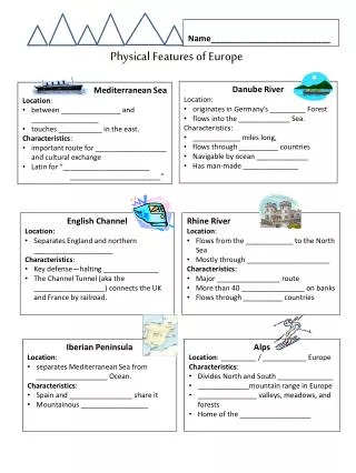
RIVERS(Flows through Germany) • DANUBE • Europe’s second longest river. • International waterway • Empties into the Black Sea • 1,771 miles • RHINE • One of the longest and most important rivers in Europe. • 766 miles • Important waterway carrying trade and goods deep inland.
European Plain • Largest mountain-free landform in Europe. • Stretches from the Pyrenees Mountains and the Atlantic Ocean in the west to the Ural Mountains in the east. • Cut by the Rhine River in the west
Mountains • ALPS • One of the great mountain range systems of Europe • Stretches from Austria in the east through Italy, Germany, and France in the west. • Highest point 15,782 ft. Italian/French border • PYRENEES • Forms a massive divider between France and Spain • Highest point 11,168 ft. • URAL • Runs from north to south through western Russia • Natural boundary between Europe and Asia • Highest point 6,213 ft.
Peninsulas • IBERIAN • Located in SW Europe • Westernmost of the three major southern European peninsulas • SCANDINAVIAN • Northern Europe • Largest peninsula of Europe
Channel • ENGLISH • Arm of the Atlanta Ocean that separates southern England from northern France and joins the North Sea to the Atlantic. • 350 miles long • 150 miles at its widest 21 miles in the Strait of Dover
Sea • MEDITERRANEAN • Connected to the Atlantic Ocean surrounded by the Mediterranean region and almost completely enclosed by land. • Part of the Atlantic Ocean • Average depth of 4,900 feet