Download
1 / 14
140 likes | 298 Views
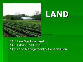
Land. Chapter 14, Section 2: Urban Land Use Standards: SEV1c, 5d. What is urbanization?. The movement of people from rural areas to cities. Mostly caused by people searching for jobs. Fast Growth vs. Slow Growth. Urban areas that grow quickly:

E N D
Land Chapter 14, Section 2: Urban Land Use Standards: SEV1c, 5d
What is urbanization? • The movement of people from rural areas to cities. • Mostly caused by people searching for jobs
Fast Growth vs. Slow Growth • Urban areas that grow quickly: • Not enough infrastructure to support so many people • Traffic jams b/c not enough roads • Overcrowded schools b/c not enough school buildings • Overflowing or malfunctioning sewer systems • Too many people can cause living conditions for all to deteriorate- called urban crisis. Shanty town on the outskirts of Hong Kong
Fast Growth vs. Slow Growth • Urban areas that grow slowly: • Roads & public transportation are built to handle growth. • Traffic flows easily. • Green spaces & recreational areas are planned. • Green spaces provide temperature moderation for the city, a place for rainwater to seep into soil (instead of flooding) and a place to relax.
What are the suburbs? • Areas on the outskirts of a city. • People usually commute into city via car or public transportation. • When city expands to countryside its called urban sprawl.
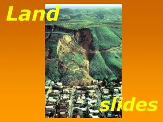
What are problems associated with urban sprawl? • Marginal Land Use • Land that is not suitable for building • Mountain sides • Coastal areas • If city is poorly planned for future growth then suburbs may expand into marginal lands. • Ex: Los Angeles was built in a valley. As population grew, people moved up the side of mountains to build homes. Homes subject to landslides.
What are problems associated with urban sprawl? 2. Heat Island Effect • Cities are warmer than rural areas • Roads/buildings trap and store more heat than vegetation. • Can alter local weather patterns • Hot air in city rises, cools, causes rain • If fewer green spaces to absorb rainfall then have more flooding • Heat leads to human health problems- heat stroke • Urban Heat Islands on The Weather Channel - YouTube
How SHOULD cities be planned? • Land-use planning- determining in advance how land will be used • Where will houses go? • Where will businesses be located? • What areas should be protected for recreation & wildlife? • Where will our water come from?
How SHOULD cities be planned? • Maglevs are magnetic levitation trains. Use magnets to start, stop, propel the train. • Maglev train video clip- The Futures Channel • Mass Transit systems • Buses • Trains (NY subway, MARTA, Maglevs) • Using mass transit • Saves energy • Reduces traffic • Reduces air pollution • Decreases land covered by road/parking lot b/c can be built above/below ground.
How SHOULD cities be planned? • Open Spaces (aka greenbelts) • Land within urban area set aside for scenic & recreational enjoyment. • Ex: parks, gardens, bike trails, hiking trails • Important for • Pollution filtration • CO2 removal • Temperature control • Absorbing water from rainstorm runoff • Exercise & relaxation
Atlanta’s Beltline Project • Transforming 22 miles of old railroad track into space for walking, biking, recreation. • First part is complete. • Government trying to raise money for entire project • BeltLine Provides New Life to Railroad Tracks in Atlanta - NYTimes.com
What tools are used by land use planners to plan development? • Geographic Information Systems (GIS)- computerized system for storing, manipulating, & viewing geographic data. • Allows planner to see layers of information so can see what is present and what could be added/altered to an area.
What are the problems associated with land-use planning? • Land-Use planning is difficult to follow through with b/c • Government requires environmental impact reports of any building projects • Citizens have right to comment on reports • Many disagreements over plans
You should be able to… • Describe the urban crisis & explain how people are addressing it. • Explain how urban areas create heat islands. • Explain how open spaces provide environmental benefits to urban areas. • Describe how a GIS system can be used as a land use planning tool.