Download
1 / 43
430 likes | 522 Views
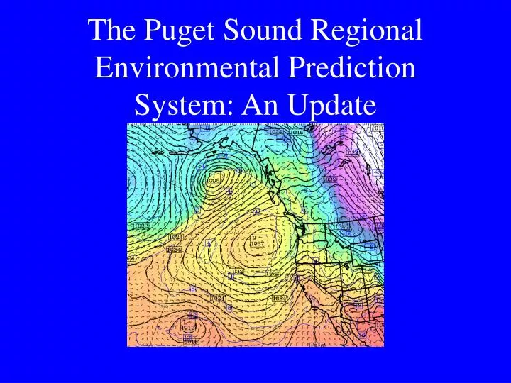
The Puget Sound Regional Environmental Prediction System: An Update. Can we create an integrated regional environmental modeling system for research and prediction by coupling preexisting models and using all operational data assets?. Current MM5 Configuration.

E N D
The Puget Sound Regional Environmental Prediction System: An Update
Can we create an integrated regional environmental modeling system for research and prediction by coupling preexisting models and using all operational data assets?
Current MM5 Configuration The Penn. State/NCAR mesoscale model V3.5 is being run: • twice a day at 36/12/4 km horizontal grid spacing. 38 levels forced by the NCEP Global Forecast System (GFS) run • 0 to 72h for 36/12 • 0 to 48 h for 4 km • Twice a day at 36/12km grid spacing forced by the NCEP Eta Model (available sooner)
Some Comments • A 4-km model does NOT resolve 4-km scale features…more like 20-25 km. • There are major issues (problems) in the physical parameterizations that we are actively working to improve, such as: • Moist physics • Land surface and boundary-layer physics • Radiation schemes
Ensemble: a 20 processor athlon cluster
WRF Cluster: The Most Powerful Computer: 32-Processor Athlon Linux Cluster
Current MM5 System • Model forecasts are verified against all regional observations • Model graphics are available on the web • Model grids are shipped to some consortium members (e.g., NWS)
A Vision of an Integrated Regional Modeling System Output from the MM5 is now being fed into a number of modeling and diagnostic systems: • Distributed Hydrological Model for Western Washington (PRISM Major Support) • Calgrid Air Quality Model • Land Surface Model for Surface Temperature Prediction • Smoke, Ventilation, and Fire Guidance • Transportation Information System And hopefully soon will be integrated with others (e.g. Puget Sound)
Terrain - 150 meter aggregated from 30 meter resolution DEM • Land Cover - 19 classes aggregated from over 200 GAP classes • Soils - 3 layers aggregated from 13 layers (31 different classes); variable soil depth from 1-3 meters • Stream Network - based on 0.25 km2 source area
Ventilation Index
U.S. Forest Service • MM5 grids are sent to the field for running Eulerian and Lagrangian smoke plume/dispersion models. • MM5 output used for fire fighting operations.
Military Applications • The NW MM5 is now the main source of regional forecasts for Navy and Air Force operations at Whidbey NAS and McChord Air Force Base, as well as the Everett Carrier homeport.
Ensemble Forecasting • A major push has been made toward ensemble forecasting using the MM5. • The goal is to provide probabilistic predictions, including forecasts of model skill. • The MM5 is now being run at 36/12 km resolution with approximately 15 different initializations and lateral boundary conditions
Regional Ensemble Configuration • Makes use of the differing initializations (and boundary conditions) from major operational NWP centers (e.g., NCEP, Navy, Canadian, UKMET, Australian, Taiwanese, etc). • Early results very encouraging (e.g., using ensembles to predict forecast skill)
Relating Forecast Skill and Model Spread Mean Absolute Error of Wind Direction is Far Less When Spread is Low
Regional Observational Database Since the mid-1980’s, have collected all available data networks in the Pacific NW Data collected and quality controlled in real-time Database used to create regional analyses available on the web and shipped to some consortium members. The database is used for verification of the regional MM5 forecasts.
Research on Physical Parameterizations • IMPROVE: To improve moist physics in mesoscale models using data from the Pacific Northwest. Multi-investigator project. Data from a major field experiment • PBL Parameterization Project: Evaluation and improvement of MM5 PBL schemes. Sponsored by the Forest Service
Should we go to higher resolution over Puget Sound?Perhaps 1.3 km?
Modeling Winds in the Columbia Gorge Cascade Locks Portland Troutdale • Strongest winds are at the exit
The Future • Hopefully, 1.3 km grid spacing domains will be added over Puget Sound and the Columbia Gorge • Major physics improvements • Seven-day runs at 36-12 km resolution • Maturation of the ensemble system • ….and…
Mesoscale Climate Forecasting • Computer power is now available to run at high resolution (12km) for 5-10 years • Driven by GCM climate predictions, could gain insights into local implications of global warming.