Download
1 / 23
230 likes | 389 Views
ESIP Air Quality Workgroup and the GEO Air Quality Community of Practice. collaboratively building an air quality community network for finding, accessing, understanding, and using shared information. Presented by Stefan Falke on behalf of the ESIP AQWG and GEO AQ CoP.

E N D
ESIP Air Quality Workgroup and the GEO Air Quality Community of Practice collaboratively building an air quality community network for finding, accessing, understanding, and using shared information Presented by Stefan Falke on behalf of the ESIP AQWG and GEO AQ CoP Techniques in Air Quality Forecasting and Reporting in Countries Outside the United States 2010 National Air Quality Conferences March 17, 2010
Distributed, Global Information SourcesDistributed, Global Decision Processes ? Source: D. McCabe, T. Keating, EPA-OAR
Distributed, Global Information SourcesDistributed, Global Decision Processes Programs and Projects Dedicated programs/projects are designed for, and serve, a specific purpose
Distributed, Global Information SourcesDistributed, Global Decision Processes Programs and Projects Together, programs/project can serve secondary purposes more effectively than each could on its own
ESIP: Federation of Earth Science Information Partners Primary Goals • Increase the use and impact of Earth science data and information • … by leveraging existing and new technologies • … to make information accessible and usable to anyone who wants it http://www.esipfed.org
ESIP: Federation of Earth Science Information Partners • Consortium of 110+ Earth Science-Related Partners • Type I (data centers) • Type II (researchers & tool developers) • Type III (application developers – commercial & nonprofit) • Type IV (sponsors) • Formed in 1998 by NASA • Funding: NASA, NOAA, and EPA • With support from: USGS and NSF • Data- and technology-centric community • Continuum of interests • Neutral forum for community networking, collaboration & problem solving • Limited (so far) international participation
ESIP: Federation of Earth Science Information Partners Activities • Societal Benefits • Air Quality and Water(active) • Energy and Climate (starting up) • Environmental Decision Making • New • Interdisciplinary • Outreach to User Communities • Technical • Systems Interoperability (standards, metadata) • Semantic Technologies • Web Services • Data Preservation and Stewardship • Workshops
ESIP Air Quality Workgroup • The objective of the ESIP Air Quality Workgroup is to connect air quality data consumers with the providers of those data by: • bringing people and ideas together on how to deliver Earth Science data to Air Quality researchers, managers and other users • facilitate and demonstrate the information flow among data providers to air quality consumers Technology Advancement data tools,methods,services users Community Building aids in reuse of data, processing tools and other services so that projects, programs and agencies avoid the end-to-end burden of developing those capabilities or having to create the connections themselves. a) brings together groups and helps build linksamong them in order to achieve an effective use of data in decision-making that could not be achieved by any organization acting on its own. data tools,methods,services users b) . . . c) http://wiki.esipfed.org/index.php/Air_Quality_Work_Group
A Global Earth Observation System of Systems (GEOSS) The Group on Earth Observations (GEO) is a partnership of 77 countries and 52 international organizations. The GEO vision is to create GEOSS and realize coordinated, comprehensive, and sustained Earth observations and shared information among countries. http://www.earthobservations.org/ The GEOten-year GEOSS plan (2005-2015)defines the vision, purpose, and scope of the system, as well as nine demonstrable “Societal Benefit Areas (SBAs)”in disasters, health, energy, climate, water, weather, ecosystems, agriculture, and biodiversity. This emerging infrastructure aims to interconnect a diverse and growing array of sensors and information systems to monitor, forecast, and assess changes in our global environment to support experts, policy makers, and decision makers.
A GEOSS Vision for Connecting Air Quality Programs/Projects Observing and Modeling Systems Unique Programs/Projects Shared, Common Information Resources Unique Programs/ Projects
A GEO Air Quality Community of Practice (CoP) is forming to advance international air quality collaborations.The AQ CoP aims toconnect and enable air quality data providersand data users tobenefit societyusing the GEO Process and GEOSS Infrastructure Observing and Modeling Systems
Observing and Modeling Systems Project A Project A combines multiple data sources to generate near-real time information for the public Project A provides web service interfaces to some of its data and information
Observing and Modeling Systems Project B Project B analyzes surface and satellite data in support of regulatory analysis and provides web services to their analysis output and analysis tools
Observing and Modeling Systems Project C Project C provides a web services new data from its work
Observing and Modeling Systems A new project uses services from projects A, B and C to meet its objectives New Project
GEO AQ Community of Practice Goal Support the development of a Functioning AQ System of Systems by 2015 By Connecting and Enabling • Use of Earth Observations • Tools & Methods for Data • Sharing Practical Knowledge AQ Community of Practice GEO Process AQ Community Source: R. Husar, Washington Univ. in StL
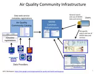
AQ CoP and the GEOSS Infrastructure AQ CoP Contributions to GEOSS GCI through the Architecture Implementation Pilot (AIP) Air quality Community Catalog AQ Community Data Finder Developed Discovery Metadata for Air Quality GEO Portals 100+ data web service metadata registrations GEOSS Common Infrastructure Air Quality Community Catalog AQ Community Data Finder Users AQ User Apps DataFed EDAC SEDAC Giovanni NGC ESA AIP-3 Workspace: http://sites.google.com/a/aip3.ogcnetwork.net/home/home/aip-3-kickoff/health-air-quality-disease
Example for finding and browsing AQ Data in GEOSS Search for AQ data GEOSS Common Infrastructure GEOSS Registry GEOSS Clearing-house Return AQ metadata Source: R. Husar, E. Robinson, K. Hoijarvi, Washington Univ. in St Louis filtered AQ metadata available to other tools and applications http://webapps.datafed.net/AQ_uFIND.aspx
CEOS Atmospheric Composition Portal Analyze difference
Interested in Participating or Learning More? Community Building • Share your interests and project contributions (like this session and conference) • Describe your information and related needs to ESIP and GEO • Use ESIP, GEO and other air quality communities of practice to advance your project objectives (e.g., ‘built-in’ testers, users; access to new information sources,…) • Help define the GEOSS Community of Practice Enhance the Information Infrastructure • Become a ‘node’ on the air quality community network to share or use data • Learn best practices in implementing standards for sharing your project data and tools • Participate in (and shape) the GEOSS Architecture Implementation Pilot • Use the AQ Community Information Architecture (register your services in GEOSS, find information resources useful for your project) • Participate in the development of air quality information networks Collaborate on AQ Science and Research Projects • Define projects that leverage expertise and capabilities across organizations • Document how data, information and capabilities are shared in the project
More Information http://wiki.esipfed.org/index.php/Air_Quality_Work_Group • ESIP at Booth #26 • Contacts: • Carol Meyer, carolbmeyer@esipfed.org • Stefan Falke, stefan.falke@gmail.com • Erin Robinson, emr1@wustl.edu
Questions for Discussion • What types of data do you use? • What types of data would like to have access to that are currently not available or inaccessible to you? • What do you do with the data you collect? (what’s being done outside the regulatory framework - analysis, storage, reporting, dissemination, etc.) • Do you ‘repackage’ your data for use by others? • What system(s) are you using to work with your data? • Do you work with any web services, web applications or web portals in finding or accessing data? • Do you face any challenges in finding, accessing, understanding, or using data? • Would you be willing to participate in a future focus group or the AQ working group (to help improve AQ data systems)?