Download
1 / 1
10 likes | 190 Views
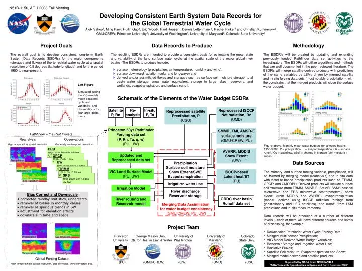
Reprocessed satellite Precipitation, P (CSU). Reprocessed ISCCP Net radiation, Rn (UMD). Satellite P, Rn. Re- analysis. In-situ P, Ta. Princeton 50yr Pathfinder Forcing data set (P, Rn, Ta, q, w) (PU, UW). SMMR, TMI, AMSR-E surface moisture (GMU/CREW, PU). AVHRR, MODIS

E N D
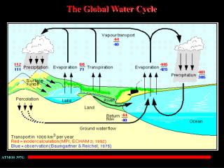
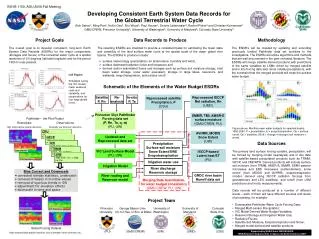
Reprocessed satellite Precipitation, P (CSU) Reprocessed ISCCP Net radiation, Rn (UMD) Satellite P, Rn Re- analysis In-situ P, Ta Princeton 50yr Pathfinder Forcing data set (P, Rn, Ta, q, w) (PU, UW) SMMR, TMI, AMSR-E surface moisture (GMU/CREW, PU) AVHRR, MODIS Snow Extent (UW) Merging/Data Assimilation, for water budget consistency (GMU/CREW, PU, UW) Updated and Reprocessed data set Precipitation Surface soil moisture Snow Extent/SWE Evapotranspiration VIC Land Surface Model (PU, UW) ISCCP-based Latent heat/ET (PU) Irrigation water use Irrigation Model River discharge Reservoir storage GRDC river basin Runoff data set River routing and Reservoir model IN51B-1150, AGU 2008 Fall Meeting Developing Consistent Earth System Data Records for the Global Terrestrial Water Cycle Alok Sahoo1, Ming Pan2, Huilin Gao3, Eric Wood2, Paul Houser1, Dennis Lettenmaier3, Rachel Pinker4 and Christian Kummerow5 GMU/CREW; Princeton University2; University of Washington3, University of Maryland4; Colorado State University5 Project Goals The overall goal is to develop consistent, long-term Earth System Data Records (ESDRs) for the major components (storages and fluxes) of the terrestrial water cycle at a spatial resolution of 0.5 degrees (latitude-longitude) and for the period 1950 to near-present. Data Records to Produce The resulting ESDRs are intended to provide a consistent basis for estimating the mean state and variability of the land surface water cycle at the spatial scale of the major global river basins. The ESDRs to produce include: Methodology The ESDR’s will be created by updating and extending previously funded Pathfinder data set activities to the investigators. The ESDRs will utilize algorithms and methods that are well documented in the peer reviewed literature. The ESDRs will merge satellite-derived products with predictions of the same variables by LSMs driven by merged satellite and in situ forcing data sets (most notably precipitation), with the constraint that the merged products will close the surface water budget. • surface meteorology (precipitation, air temperature, humidity and wind), • surface downward radiation (solar and longwave) and • derived and/or assimilated fluxes and storages such as surface soil moisture storage, total basin water storage, snow water equivalent, storage in large lakes, reservoirs, and wetlands, evapotranspiration, and surface runoff. Left Figure: Simulated (using the VIC model) mean seasonal cycle and variability, and observations for four large global rivers. Schematic of the Elements of the Water Budget ESDRs Pathfinder – the Pilot Project Reanalysis High temporal/low spatial resolution Observations Generally low temporal resolution Figure above: Monthly mean water budgets for selected basins, 1950-2000. P = precipitation, E = evapotranspiration, Qs = surface runoff, Qb = baseflow, dS/dt = change in storage (soil moisture + snow). CRU 1901-2000, Monthly, 0.5deg P, T, Tmin, Tmax, Cld GPCP 1997-, Daily, 1.0de P Precipitation • Data Sources • The primary land surface forcing variable, precipitation, will be formed by merging model (reanalysis) and in situ data with satellite-based precipitation products such as TRMM, GPCP, and CMORPH. Derived products will include surface soil moisture (from TRMM, AMSR-E, SMMR, SSM/I passive microwave and ERS microwave scatterometers), snow extent (from MODIS and AVHRR), evapotranspiration (model- derived using ISCCP radiation forcings from geostationary and LEO satellites), and runoff (from LSM predictions and in-situ measurements). • Data records will be produced at a number of different levels – each of them will have different sources and levels of processing, for example: • Downscaled Pathfinder Water Cycle Forcing Data; • Merged Multi-sensor Precipitation; • VIC Model Derived Water Budget Variables; • Reservoir Storage and Irrigation Water Use; • Radiative Fluxes; • Satellite Soil Moisture, Evapotranspiration and Snow; • Merged model derived and satellite products. UW 1979-2000, Daily, 2.0deg P TRMM 2002-, 3hr, 0.25deg P Temperature SRB 1985-2000, 3hr, 1.0deg Lw, Sw SW Radiation • Bias Correct and Downscale • corrected rainday statistics, undercatch • removal of biases in monthly values • removal of spurious trends in SW • adjustment for elevation effects • downscale in time and space Project Team Princeton George Mason Univ. University of University of Colorado University Ctr. for Res. in Env. & Water Washington Maryland State Univ. (PU) (GMU/CREW) (UW) (UMD) (CSU) Precipitation SW Radiation Temperature Diurnal Cycle Global Forcing Dataset High temporal/high spatial resolution, bias corrected, trend corrected, etc… Supported by NASA Grant NNX08AN40A “NRA/Research Opportunities in Space and Earth Sciences-2006”