Download
1 / 18
190 likes | 355 Views
Geographic Condition of Bangladesh. Presented by Md. Rabiul Islam Rabi Senior Lecturer, GED Northern University Bangladesh E-mail: mdrabi_ju@yahoo.com Cell : 01712-541463. Geographic Condition of Bangladesh. Defining Geography :

E N D
Geographic Condition of Bangladesh Presented by Md. Rabiul Islam Rabi Senior Lecturer, GED Northern University Bangladesh E-mail: mdrabi_ju@yahoo.com Cell : 01712-541463
Geographic Condition of Bangladesh Defining Geography: Geography (from Greek geografia) is the study of the Earth and its lands, features, inhabitants, and phenomena. A literal translation would be "to describe or write about the Earth". The first person to use the word "geography" was Eratosthenes (276-194 B.C.) Study of the earth's surface; includes people's responses to topography and climate and soil and vegetation.
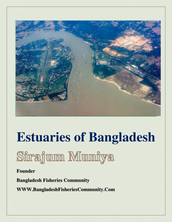
Geographic Condition of Bangladesh Geography of Bangladesh: Bangladesh is in the low-lying Ganges-Brahmaputra River Delta or Ganges Delta. This delta is formed by the confluence of the Ganges (local name Padma or Pôdda), Brahmaputra ( Jomuna), and Meghna rivers and their respective tributaries. The alluvial soil deposited by these rivers has created some of the most fertile plains in the world. Bangladesh has 58 trans-boundary rivers, making water issues politically complicated to resolve - in most cases as the lower riparian state to India.
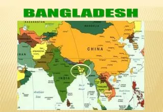
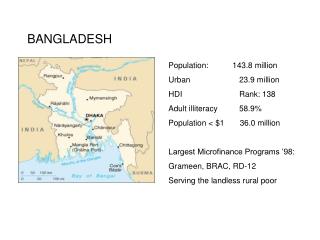
Geographic Condition of Bangladesh Geography of Bangladesh (cont’d) Location: Between 20.340 and 26.380 north latitude and between 88.01 and 92.41 east longitude. Area 1,47,570 sq. km or 56,977 sq. miles. Territorial waters 22.22 km. or 12 Nautical Miles Economic Zone-up to 370.40 km.In the high seas, measured from the base line. Boundary North : India, West : India, East : India & Myanmar, South : Bay of Bengal.
Geographic Condition of Bangladesh Monsoon Rainfall: Lowest 160 cm. Highest 400 cm. Humidity: Highest 99%, Lowest 36%. Main Season: Winter (November-February), Summer (March-June), Monsoon (July-October). Principal Rivers: Padma,Meghna, Jamuna, Brahmaputra, Teesta, Surma and Karnaphuli. Principal Minerals: Natural Gas, Lignite Coal, Limestones, Ceramic, Clay and Glass sand.
Geographic Condition of Bangladesh Climate of Bangladesh Defining Climate: Climate (from Ancient Greek klima, meaning inclination) is commonly defined as the weather averaged over a long period of time. The standard averaging period is 30 years, but other periods may be used depending on the purpose. The difference between climate and weather is usefully summarized by the popular phrase "Climate is what you expect, weather is what you get.
Geographic Condition of Bangladesh Climate of Bangladesh Bangladesh has a subtropical monsoon climate characterized by wide seasonal variations in rainfall, moderately warm temperatures, and high humidity. Regional climatic differences in this flat country are minor. Three seasons are generally recognized: ▶a hot, humid summer from March to June; ▶ a cool, rainy monsoon season from June to October; and ▶ a cool, dry winter from October to March. In general, maximum summer temperatures range between 32°C and 38°C.
Geographic Condition of Bangladesh Climate of Bangladesh _cont’d. April is the warmest month in most parts of the country. January is the coldest month, when the average temperature for most of the country is 10°C. Heavy rainfall is characteristic of Bangladesh. About 80 percent of Bangladesh's rain falls during the monsoon season. Natural calamities, such as floods, tropical cyclones, tornadoes, and tidal bores destructive waves or floods caused by flood tides rushing up estuaries--ravage the country, particularly the coastal belt, almost every year.
Geographic Condition of Bangladesh Climate Change in Bangladesh Bangladesh threatens to be one of the first, and surely will be one of the major victims. For the country is extremely vulnerable to climate change than most other nations on earth. Bangladesh’s vulnerability is more than average. It is larger for instance than that of deltaic regions belonging to the world’s global north. the issue of climate change, as the geography of poverty in Bangladesh brings out, is also, partly, a class issue. Landlessness is a problem which exists throughout Bangladesh.
Geographic Condition of Bangladesh Rivers of Bangladesh: Definition of River: long water course that flows down a slope along a bed between banks. It originates from a 'source' and culminates to a sea or lake at its 'mouth'. Along its length it may be joined by smaller rivers called 'tributaries'. A river and its tributaries form a 'river system'.
Geographic Condition of Bangladesh Rivers of Bangladesh_cont’d: The pride of Bangladesh is its rivers with one of the largest networks in the world with a total number of about 700 rivers including tributaries, which have a total length of about 24,140 km. Rivers are the most important geographical features in Bangladesh, and it is the rivers that created the vast alluvial delta. It’s been known that the out flow of water from Bangladesh is the third highest in the world, after the Amazon and the Congo systems.
Geographic Condition of Bangladesh Rivers of Bangladesh_cont’d: Bangladesh is proud of its vast rivers and therefore affectionately called ‘the Land of Rivers’ by its people. Every year they enrich the soil and make it more fertile. At the same time they also cause immense loss of lives and wealth when the devastating floods occur. Bangladesh has predominantly four major river systems – (1) the Brahmaputra-Jamuna, (2) the Ganges-Padma, (3) the Surma-Meghna, and (4) the Chittagong Region river system. However, Brahmaputra is the 22nd longest (2,850 km) and the Ganges is the 30th longest (2,510 km) river in the world.
Geographic Condition of Bangladesh Tipaimukh Dam The proposed Tipaimukh dam is to be located 500 metres downstream from the confluence of Barak and Tuivai rivers, and lies on the south-western corner of Manipur State. It is a huge earth dam (rock-fill with central impervious core) having an altitude of about 180 M above the sea-level with a maximum reservoir level of 178m and 136m as the MDDL (minimum draw down level). Despite protests from within India and Bangladesh, India is going ahead with the construction of the massive Tipaimukh barrage on the Barack river near the border, which will reduce the water flow in Surma and Kushiara rivers in Bangladesh.
Tipaimukh Dam_ cont’d By constructing the Tipaimukh Dam India is only looking into its own interest. And Bangladesh would have to face serious consequences if this dam is constructed. Even the people of Manipur and Nagaland would also have to suffer. The Barak-Surma-Kushiara is an international river. Therefore, Bangladesh, being a lower riparian country, has the right to an equitable share of the water from the river.
Geographic Condition of Bangladesh Tipaimukh Dam_ cont’d Expert fear once the dam is set up, it may be reduce the natural monsoon flood patterns in the Sylet region, adversely affecting cultivation and livelihood on a vast scale. “It will increase the risk of floods at the end of monsoon and hamper the agriculture patterns during winter.” _ said Ainun Nishat. They would preserve the water during monsoon after building the dam and release it in winter, which will increase the water flow downstream.
Tipaimukh Dam_ cont’d Prof. Mustafizur Rahman Tarafdar, a water resources expert, in an article titled ‘Tipaimukh Dam: An alarming venture’, discussed the ill-effects of the Tipaimukh Dam. If this dam is eventually constructed as intended, Bangladesh would have to suffer the adverse effects. This dam would lead to hydrological drought and environmental degradation. The dam would cause the Surma and Kushiara to run dry during November to May which would eventually hamper agriculture, irrigation, navigation, shortage of supply of drinking water, etc.
Tipaimukh Dam_ cont’d Unilateral water diversion, or withdrawal of water from international or common rivers, has been the long-standing policy of India. India has seldom bothered to think about the impact of such policies on a lower riparian country, such as Bangladesh, in diverting water from common rivers. India is withdrawing waters of almost all the common rivers by building dams on the upstream, which will eventually cause Bangladesh to turn into a desert. The Padma River is drying up in Rajshahi after construction of Farakka Barrage (1972). Twenty tributaries of the river have turned into streamlets.
The role of the Bangladesh government in this matter is quite confusing. Despite the rising protests from all corners, the government seems to be undermining the threats posed by the construction of this dam. Only recently the prime minister of Bangladesh has said the government intends to form a committee to evaluate all aspects regarding construction of the dam before making any decisions on this controversial project. It might be that the government is envisaging some benefits from the construction of this controversial dam, namely import of electricity. In April 2009, the Indian government had invited a Bangladeshi delegation to see the construction of the planned Tipaimukh Dam on the Barak.