Download
1 / 16
160 likes | 310 Views
National Hydrologic Model Overview. Steve Markstrom U.S. Geological Survey Lakewood, Colorado. What Is a National Hydrologic Model?.

E N D
National Hydrologic ModelOverview Steve Markstrom U.S. Geological Survey Lakewood, Colorado
What Is a National Hydrologic Model? Accurate estimates of total water availability, changes in the timing and source of flow and reliable measures of the uncertainty of these estimates are essential in assessing the response of the Nation’s water resources, ecosystems and dependent aquatic and terrestrial plant and animal communities to climate and land use changes. • Development of standard methods to produce consistent and comparable hydrologic model studies. • Development of technology which makes the best available datareadily accessible to hydrologic modelers. This includes dissemination of results from model studies in a consistent and efficient manner. • Relevant research and development in the field of hydrologic modeling to answer increasingly complex questions, and to take advantage of improved data sources as they become available. • Development of a modeling archiveprocess which provides a platform for model distribution, comparability, and interoperability. This archive process is a key to coupling models from diverse scientific disciplines.
What Are the Components of a National Hydrologic Model? Hydrologic models and software tools National “Geospatial Fabric” to provide a consistent spatial context for any study, model application, data collection, etc. • Sources of the best available data : • National extent • Freely available • Model ready (processing and formatting)
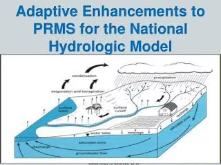
Watershed Models Temperature Precipitation Potential Evapotranspiration Snow Rain Actual Evapotranspiration Snow Melt Snow Storage Direct Runoff Surplus Runoff Soil-Moisture Storage Capacity Soil-Moisture Storage Lauren Hay Steve Markstrom Steve Regan Roland Viger Andy Bock Christian Ward-Garrison Shannon Poole Monthly Water Balance Model Modeling of Watershed Systems (MoWS) PRMS Precipitation Runoff Modeling System GSFLOW Coupled ground-water and surface-water flow model based on the integration of PRMS and MODFLOW (Modular Ground-Water Flow Model) SNTEMP Stream Network TEMPeraturemodel MWBM Monthly Water Balance Model (w/Dwight Atkinson and Greg McCabe) The coupling of PRMS with SNTemp will allow scientists and watershed managers to evaluate the effects of historical climate and projected climate change, landscape evolution, and resource management scenarios on watershed hydrology and in-stream water temperature. PRMS Conceptualization of Basin Components Modular, deterministic, distributed-parameter, physical-process, daily time-step watershed model that simulates watershed response to various combinations of climate and land use.
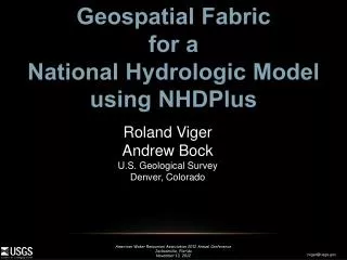
Creating a Geospatial Fabric for National-Scale Hydrologic Modeling Objective – Simulate streamflow values at any point in the US • Create a consistent national geospatial fabric from NHDPlus • Drive PRMS and MWBM • Infrastructure for National Hydrologic Model • Easily support/compare other efforts
Loch Vale Watershed, CO NHDPlus Region 10Lower John Walker (WI WSC)
Loch Vale Watershed, CO 100km2 1.5km2
Loch Vale Watershed, CO 100km2 1.5km2
Geo Data Portal (GDP) • Center for Integrated Data Analytics (CIDA) • http://cida.usgs.gov/gdp/ The GDP is a portal (website) that can provide information summarized to a set of spatial features: • Spatial data for model input (e.g., DEMs, land cover, soils, geology) • Climate data for model forcing (http://cida.usgs.gov/climate/gdp/) • Loosely couple models (upload your own model results into THREDDS) Nathaniel L. Booth,Tom Kunicki, Ivan Suftin , Dave Blodgett, Jordan Walker (CIDA)
Hydrologic Model (parameterization) Spatial parameters • GIS interface • GDP Vegetation Impervious Area Land Cover Terrain and Hydrology
Current Condition Climate data for model forcing available from GDP Andy Bock (CO WSC) Greg McCabe (NRP) Dwight Atkinson (EPA)
GeoData Portal (GDP) Hydrologic Response Units (HRUs) Shape File Best Available Data GDP HRU summary Mapped to model format
What happened behind the scenes? Statistical summaries of gridded output by basin subunits Gridded output
Questions http://wwwbrr.cr.usgs.gov/mows