Download
1 / 1
10 likes | 223 Views
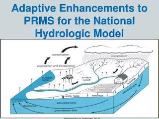
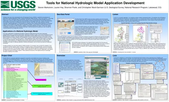
Downsizer Client Data acquisition user interface. Downsizer Server Remote Method Invocation Service. External Data Best available external sources. Dispatcher. Input Files for Model. Data Acquisition Portal. Worker. Interface. Quality Controller. Interface. Interface. Formatter.

E N D
Downsizer Client Data acquisition user interface Downsizer Server Remote Method Invocation Service External Data Best available external sources Dispatcher Input Files for Model Data Acquisition Portal Worker Interface Quality Controller Interface Interface Formatter NWIS Daily streamflow data NWIS: U.S. Geological Survey National Water Information System COOP: National Oceanic and Atmospheric Administration Cooperative Observer Program SNOTEL: U.S. Department of Agriculture, Natural Resources Conversation Service, National Water and Climate Center, Snow Survey and Water Supply Forecasting Program COOP Daily climate data SNOTEL Daily climate data Tools for National Hydrologic Model Application Development Steven Markstrom, Lauren Hay, Shannon Poole, and Christopher Ward-Garrison (U.S. Geological Survey, National Research Program, Lakewood, CO) Lumen Abstract Downsizer Software tools have been developed by the US Geological Survey (USGS) to simplify the development of watershed modeling applications within a National Hydrologic Model structure. These tools include: (1) Geo Data Portal, (2) Lumen, (3) Project Chief, (4) Downsizer, and (5) Luca. The Geo-Data Portal simplifies access to spatial data. Lumen provides visualization and subsetting of existing parameter files. Project Chief streamlines and simplifies the process of setting up the directory structure, input files, and maps required to develop hydrologic modeling applications. The Downsizer is a Graphical User Interface-based application for browsing, acquiring, and formatting time-series data for hydrologic modeling. Luca provides an easy systematic way of building and executing a multiple-objective, stepwise, automated calibration procedure. These tools support coordinated, comprehensive, and consistent hydrologic model development by guiding the user through the model development and application process. Lumen is a computer application for analyzing a stream network represented within a Precipitation-Runoff Modeling System parameter file. It performs 4 essential functions: (1) constructs the stream network graph; groups segments into rounds; (3) draws a schematic; and (4) generates child parameter files. Lumen requires certain parameters be available within the file in order to perform these functions. The Geo Data Portal (GDP) project provides scientists and environmental resource managers access to downscaled climate projections and other data resources that are otherwise difficult to access and manipulate. This user interface demonstrates an example implementation of the GDP project web-service software and standards-based data integration strategy. Example Application: Using Lumen to Setup Parameter Regionalization Scheme A user of the GDP interface can supply their area of interest as a pre-existing GIS shape file with one to many unique polygons or by drawing a single polygon using an interactive web-map. A user can select from available GDP project web-service processing algorithms, which include raw data subsetting and area-weighted statistics summarization. Project Chief Figure 3. Options for checking out child parameter files Applications of a National Hydrologic Model Calibration gage (poi_type=1) Gage (poi_type=0) Stream segment break In the past, applications of watershed simulation models by USGS personnel have been developed independently and on a project by project basis. Hydrologic simulation models, such as the Precipitation Runoff Modeling System (PRMS), have been applied to watersheds according Water Science Center project needs, National Research Program research and development, as part of regional water balance simulations for large thrust projects, or for a variety of other reasons. These applications were made with little thought of collaboration or reuse for other purposes, and generally have not been relevant outside of the context in which they were developed. This is because of (1) differing temporal and spatial scales and resolutions, (2) evolving data availability and needs, (3) differing calibration methods and purpose, and (4) internal and external institutional constraints. Complex questions are now being asked of USGS scientists. For example, how to protect the integrity of river ecosystems and flow regimes under conditions of changing climate, evolving landscapes, and ever increasing demand on resources. The hydrologic simulation models and methods required to support this level of decision making must be of the highest scientific integrity, reduce duplication of effort, promote collaboration, and support the USGS streamflow information network. These objectives should be of the highest priority for hydrologic simulation modeling in the USGS. Processing algorithm options such as dataset component of interest, time period of interest and output file formatting must be specified. As the GDP project progresses, other processing algorithms and output formatting options will become available. Datasets available from the initial public release of the portal include historic weather and downscaled climate projections. Figure 4. Check in for child parameter files Figure 2. Parameter file for regionalization in lumen Figure 1. Initial parameter file in lumen As the GDP project progresses, the catalog of data available from the portal will expand to include more climate, weather and geographic data resources. In order to allow processing of very large datasets, GDP project web services perform asynchronously. This allows a user to supply an email address and be notified upon process completion. Determine which gages to use for calibration and set parameter poi_type=1 at these locations. Open parameter file in Lumen (Fig. 1). Gray stream segments have no calibration gages downstream. Colored segments indicate segments with a calibration gage downstream. To calibrate parameters associated with gray areas, ‘move’ the influence of the calibration gage downstream (red lines on Fig. 1) by changing poi_type parameters. Figure 2 shows the new lumen configuration. Check out child parameter files for Round 1 (Fig. 3), calibrate, then check in (Fig. 4). Continue until all rounds are processed. Luca Geo-Data Portal STATUS: available at http://cida.usgs.gov/climate/gdp/ STATUS: in development; documentation in review Luca (Let us calibrate) is a wizard-style user-friendly GUI that provides an easy systematic way of building and executing a multiple-objective, stepwise, automated calibration procedure for the Precipitation-Runoff Modeling System. using the Shuffled Complex Evolution global search algorithm. This calibration process assures that intermediate and final states of the model are simulated consistently with measured values. Project Chief is a computer application designed to streamline and simplify the process of setting up the Precipitation-Runoff Modeling System. The Project Chief uses a GUI wizard to guide the user through the setup from beginning to end; correcting and minimizing errors that occur. Project Chief is designed to be used at any point of the PRMS setup. It can be used at the very start of a PRMS project, guiding the user through the entire process. Downsizer is a computer application that selects, downloads, verifies, and formats station-based time-series data for environmental-resource models, particularly the Precipitation-Runoff Modeling System. Downsizer implements the client-server software architecture. The client presents a map-based, graphical user interface that is intuitive to modelers; the server provides streamflow and climate time-series data from over 40,000 measurements stations across the United States. Example : Luca GUI Setup for a 6 Round 7 Step Calibration Screen image of the Project Chief upon startup showing (1) the title bar, (2) the main frame, (3) the preview frame, and (4) the navigation buttons. GUI Screens 5 LIST OF PROJECT CHIEF GUI STEPS Welcome Specify root path for the project Data File Selection List of Errors and Warnings Data file completed Control File Selection Create a new control file Comment the Control File Specify the executable model file Select Depression Storage Model Select Cascade Mode Specify Temperature Distribution module Specify Precipitation Distribution module Specify the Solar Radiation module Specify the Potential Evapotranspiration module Specify the Surface Runoff module Specify the Capillary Reservoir module Specify the Gravity Reservoir module Specify the Streamflow routing module Specify the Transpiration module Specify the PRMS output files Control File completed Parameter File selection Create a new parameter file Comment the Parameter File Specify GIS Weasel data_bin files Run the GIS Weasel Parameter File Completed Finished 9 6 11 High Flows Low Flows 1 Check the Data File 12 Downsizer implements the client-server software architecture (figure on the left). Both the client and server are written in the Java programming language. The Downsizer client presents a map-based, graphical user interface that is intuitive to modelers. The client sends requests for data to the Downsizer server. The server provides access to daily streamflow data values from the U.S. Geological Survey National Water Information System, and daily minimum and maximum temperature and precipitation data values from the National Oceanic and Atmospheric Administration Cooperative Observer Program and the U.S. Department of Agriculture, Natural Resources Conversation Service, National Water and Climate Center, Snow Survey and Water Supply Forecasting Program (SNOTEL). 2 7 13 10 Check the Control File (if supplied) or makes a new one 3 8 Check the Parameter File (if supplied) or makes a new one 4 STATUS: available at http://wwwbrr.cr.usgs.gov/projects/SW_MoWS/LUCA.html STATUS: available at http://wwwbrr.cr.usgs.gov/projects/SW_MoWS/Downsizer.html STATUS: in development; documentation in review