Download
1 / 1
10 likes | 195 Views
Generation of a Weather Database on Crustal Dynamics Data Information System (CDDIS). Science Justine Woo, Carnegie Mellon University. Stephen Merkowitz , 690.2 Jan McGarry , 694. ABSTRACT. DISCUSSION AND CONCLUSION. METHODS, MATERIALS, AND RESULTS.

E N D
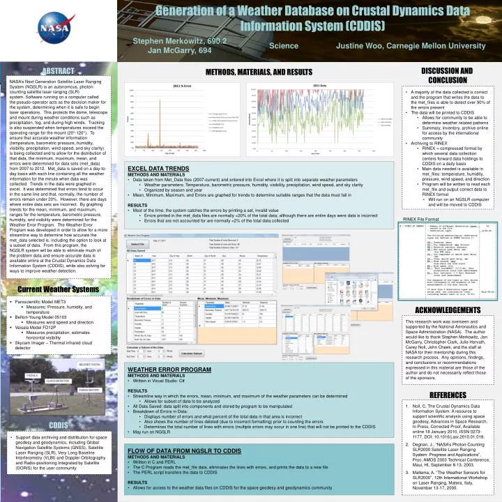
Generation of a Weather Database on Crustal Dynamics Data Information System (CDDIS) Science Justine Woo, Carnegie Mellon University Stephen Merkowitz, 690.2 Jan McGarry, 694 ABSTRACT DISCUSSION AND CONCLUSION METHODS, MATERIALS, AND RESULTS NASA’s Next Generation Satellite Laser Ranging System (NGSLR) is an autonomous, photon-counting satellite laser ranging (SLR) system. Software running on a computer called the pseudo-operator acts as the decision maker for the system, determining when it is safe to begin laser operations. This protects the dome, telescope and mount during weather conditions such as precipitation, fog, and during high winds. Tracking is also suspended when temperatures exceed the operating range for the mount (20°-120°). To ensure that accurate weather information (temperature, barometric pressure, humidity, visibility, precipitation, wind speed, and sky clarity) is being collected and to allow for the distribution of that data, the minimum, maximum, mean, and errors were determined for data sets (met_data) from 2007 to 2012. Met_data is saved on a day-to-day basis with each line containing all the weather information for the minute when data was collected. Trends in the data were graphed in excel. It was determined that errors tend to occur in the same line and that, normally, the number of errors remain under 20%. However, there are days where entire data sets are incorrect. By graphing trends for the mean, minimum, and maximum, ranges for the temperature, barometric pressure, humidity, and visibility were determined for the Weather Error Program. The Weather Error Program was developed in order to allow for a more streamline way to determine how accurate the met_data selected is, including the option to look at a subset of data. From this program, the NGSLR system will be able to eliminate much of the problem data and ensure accurate data is available online at the Crustal Dynamics Data Information System (CDDIS), while also solving for ways to improve weather detection. • A majority of the data collected is correct and the program that writes the data to the met_files is able to detect over 90% of the errors present • The data will be printed to CDDIS • Allows for community to be able to determine weather related patterns • Summary, inventory, archive online for access by the international community • Archiving to RINEX • RINEX = compressed format by which several data collection centers forward data holdings to CDDIS on a daily basis • Main data needed is available in met_files: temperature, humidity, pressure, wind speed, and direction • Program will be written to read each met_file and output correct data to RINEX format • Will run on an NGSLR computer and will be moved to CDDIS • EXCEL DATA TRENDS • METHODS AND MATERIALS • Data taken from Met_Data files (2007-current) and entered into Excel where it is split into separate weather parameters • Weather parameters: Temperature, barometric pressure, humidity, visibility, precipitation, wind speed, and sky clarity • Organized by season and year • Mean, Minimum, Maximum, and Errors are graphed for trends to determine suitable ranges that the data must fall in • RESULTS • Most of the time, the system catches the errors by printing a set, invalid value • Errors printed in the met_data files are normally <20% of the total data; although there are entire days were data is incorrect • Errors that are not accounted for are normally <2% of the total data collected RINEX File Format Current Weather Systems • Paroscientific Model MET3 • Measures: Pressure, humidity, and temperature • Belfort-Young Model 05103 • Measures wind speed and direction • Vaisala Model FD12P • Measures precipitation, estimates horizontal visibility • Skycam Imager – Thermal infrared cloud detector ACKNOWLEDGEMENTS This research work was overseen and supported by the National Aeronautics and Space Administration (NASA). The author would like to thank Stephen Merkowitz, Jan McGarry, Christopher Clark, Julie Horvath, Carey Noll, John Cheek, and the staff at NASA for their mentorship during this research process. Any opinions, findings, and conclusions or recommendations expressed in this material are those of the author and do not necessarily reflect those of the sponsors. • WEATHER ERROR PROGRAM • METHODS AND MATERIALS • Written in Visual Studio: C# • RESULTS • Streamline way in which the errors, mean, minimum, and maximum of the weather parameters can be determined • Allows for subset of data to be analyzed • All Data Saved: data split into components and stored by program to be manipulated • Breakdown of Errors in Data: • Displays number of errors and what percent of the total data in that area is incorrect • Also shows the number of lines deleted (due to incorrect formatting) prior to counting the errors • Determines the total number of lines with errors (multiple errors may occur in one line) that will not be printed to the CDDIS • May run on NGSLR REFERENCES Noll, C. The Crustal Dynamics Data Information System: A resource to support scientific analysis using space geodesy, Advances in Space Research, In Press, Corrected Proof, Available online 18 January 2010, ISSN 0273-1177, DOI: 10.1016/j.asr.2010.01.018. Degnan, J., “NASA’s Photon-Counting SLR2000 Satellite Laser Ranging System: Progress and Applications”, Proc. AMOS 2003 Technical Conference, Maui, HI, September 8-13, 2003. Mallama, A. “The Weather Sensors for SLR2000”, 12th International Workshop on Laser Ranging, Matera, Italy, November 13-17, 2000. CDDIS • Support data archiving and distribution for space geodesy and geodynamics, including Global Navigation Satellite Systems (GNSS), Satellite Laser Ranging (SLR), Very Long Baseline Interferometry (VLBI) and Doppler Orbitography and Radio-positioning Integrated by Satellite (DORIS) for the user community • FLOW OF DATA FROM NGSLR TO CDDIS • METHODS AND MATERIALS • Written in C and PERL • The C Program reads the met_file data, eliminates the lines with errors, and prints the data to a new file • The PERL script transfers the data to CDDIS • RESULTS • Allows for access to the weather data files on CDDIS for the space geodesy and geodynamics community