Download
1 / 32
320 likes | 325 Views
Western Washington Hydrology Model Version 3. Vancouver, WA, Workshop October 17, 2007 AM. Western Washington Hydrology Model Version 3. Instructors: Doug Beyerlein, P.E. Joe Brascher Clear Creek Solutions, Inc. www.clearcreeksolutions.com. Clear Creek Solutions’ Hydrology Expertise.

E N D
Western Washington Hydrology ModelVersion 3 Vancouver, WA, Workshop October 17, 2007 AM
Western Washington Hydrology ModelVersion 3 Instructors: Doug Beyerlein, P.E. Joe Brascher Clear Creek Solutions, Inc. www.clearcreeksolutions.com
Clear Creek Solutions’ Hydrology Expertise Clear Creek Solutions, Inc., provides complete range of hydrologic and stormwater modeling services. • Clear Creek specializes in continuous simulation hydrologic modeling. • We have 30+ years of experience modeling complex hydrologic and stormwater problems. • We created WWHM3 for Washington State Department of Ecology and are adapting it to model San Francisco Bay Area watersheds and facilities. • We teach WWHM and HSPF workshops.
WWHM Introduction • Developed for the State of Washington Department of Ecology. • Project Manager: Dr. Foroozan Labib • Department of Ecology • PO Box 47600 • Olympia, WA 98504-7600 • (360) 407-6439 email: flab461@ecy.wa.gov
WWHM Introduction Developed for the 19 counties of western Washington. Part of Ecology’s Stormwater Management Manual
WWHM Introduction WWHM3 Standard is available free from the Washington State Department of Ecology web site: http://www.ecy.wa.gov/programs/wq/stormwater/
WWHM Background and Theory • Ecology’s Stormwater Management Manual • Specifies a flow duration standard • Requires the use of Western Washington Hydrology Model (WWHM) or equivalent
WWHM Background and Theory • Flow duration standard: based on erosive flows. Erosive flow range: ½ of 2-year to 50-year flow.
WWHM Background and Theory Flow Duration Analysis: Percent of time the flow exceeds a specific value. • Requires continuous simulation hydrology to compute flow duration.
WWHM Background and Theory • Continuous simulation hydrology models the entire hydrologic cycle for multiple years. Stormwater runoff = surface runoff + interflow.
WWHM Capabilities • WWHM uses continuous simulation hydrology to compute stormwater runoff for both predevelopment and post-development conditions. Predevelopment Post-development
WWHM Capabilities • WWHM continuous simulation computations from HSPF (included in WWHM software). • HSPF runs in the background with calibrated parameter values and local meteorological data. • HSPF sponsored and funded by EPA and USGS.
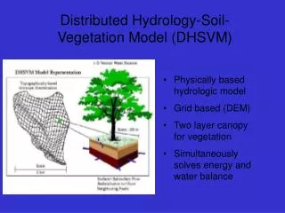
How WWHM/HSPF works • Drainage areas are divided into pervious land segments based on soil, vegetation, and land slope and impervious land segments. • Pervious and impervious segments are linked to conveyance pathways (pipes, ditches, ponds, streams, rivers, lakes, etc.) • Historic rainfall and evaporation are used as input.
How WWHM/HSPF works • The entire water cycle is modeled on an hourly or shorter time step for multiple years. • The model computes changes in soil moisture, evapotranspiration, and runoff every time step. • Three types of runoff: • surface runoff • interflow • groundwater/base flow
How WWHM works • Calibrated parameter values are built into WWHM (different calibrated parameter values are used for different climatic regions). • Local precipitation and evaporation data are included in WWHM.
How WWHM works • User locates project on county map, inputs pre- and post-development land use, and proposed mitigation measure(s). • Predevelopment and mitigated flows are compared at Point of Compliance (POC). • Mitigated flows are not allowed to exceed flow duration standards.
How WWHM works • User outputs report file and project file. • Output files can be submitted to the permitting agency for approval. • Permitting agency can load project file and rerun analysis, if needed. • Report file summarizes input data and output results.
How WWHM works • Guidance/help is provided by • User Manual • Training Workshops • CCS Project Book* • Tech Support* * Go to www.clearcreeksolutions.com for more details.
WWHM Version 3: Goal: give the user greater flexibility and options: • High groundwater element • Lateral flow between basins • More elements • More output options • New LID options
WWHM Version 3: Version 3 projects have no drainage area size limitations: entire watersheds can be modeled. Version 3 can be customized to local jurisdictions (e.g., City of Bellingham, City of Seattle).
WWHM3 Standard: • 14 elements: • basin • trapezoidal pond • tank • lateral pervious basin (NEW) • high groundwater/wetland (NEW) • vault • open channel (NEW) • time series (NEW) • lateral impervious basin (NEW) • gravel trench bed (NEW) • sand filter • flow splitter (IMPROVED) • irregular-shaped pond • stage-storage-discharge table
WWHM3 PRO Basic: WWHM3 Standard plus: • user selected time step (5 minutes to one hour) • tagged flow routing • additional elements • culverts • green/vegetated/eco-roofs • bioretention swales/rain gardens
WWHM3 PRO GIS: WWHM3 PRO Basic plus: • Map Explorer
GIS Import Process Diagram 1 4 5 2 3 WWHM3 PRO GIS: WWHM3 PRO Basic plus: • GIS Import
WWHM3 PRO SWMM: WWHM3 PRO Basic plus: • SWMM Routing
WWHM3 PRO Complete: WWHM3 PRO Basic plus: • SWMM • GIS
WWHM3 LID Modeling • Green/vegetated/eco-roof • Bioretention swales/rain gardens • Porous pavement
WWHM3 LID Modeling Green/vegetated/eco-roof
WWHM Green Roof Modeling Study performed for Seattle Public Utilities Green roof modeled: Portland Hamilton Building Data provided by Portland BES
WWHM Rain Garden Modeling Seattle Bioretention Swales
WWHM Rain Garden Modeling Weir and vertical orifice outlet Amended Soil (1-3 layers) Native Soil Native Soil Underdrain (optional) Native Soil
WWHM Porous Pavement Modeling Currently represented by the gravel trench bed element.