Download
1 / 2

E N D
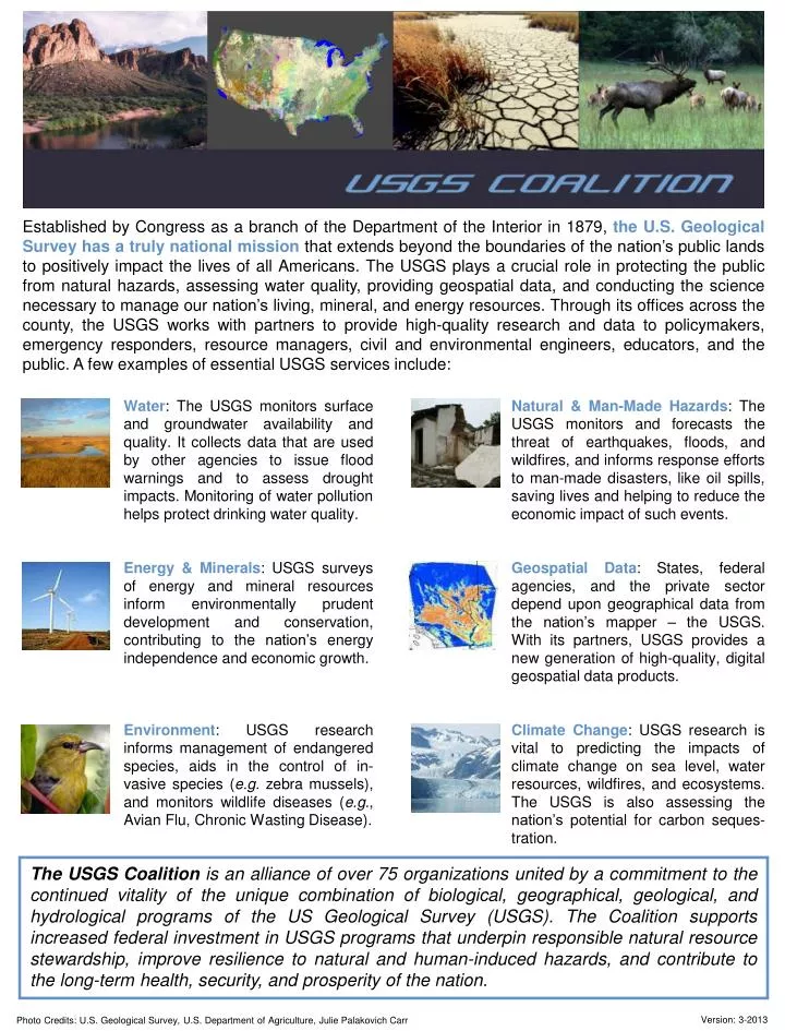
Established by Congress as a branch of the Department of the Interior in 1879, the U.S. Geological Survey has a truly national mission that extends beyond the boundaries of the nation’s public lands to positively impact the lives of all Americans. The USGS plays a crucial role in protecting the public from natural hazards, assessing water quality, providing geospatial data, and conducting the science necessary to manage our nation’s living, mineral, and energy resources. Through its offices across the county, the USGS works with partners to provide high-quality research and data to policymakers, emergency responders, resource managers, civil and environmental engineers, educators, and the public. A few examples of essential USGS services include: • Water: The USGS monitors surface and groundwater availability and quality. It collects data that are used by other agencies to issue flood warnings and to assess drought impacts. Monitoring of water pollution helps protect drinking water quality. • Energy & Minerals: USGS surveys of energy and mineral resources inform environmentally prudent development and conservation, contributing to the nation’s energy independence and economic growth. • Environment: USGS research informs management of endangered species, aids in the control of in-vasive species (e.g. zebra mussels), and monitors wildlife diseases (e.g., Avian Flu, Chronic Wasting Disease). • Natural & Man-Made Hazards: The USGS monitors and forecasts the threat of earthquakes, floods, and wildfires, and informs response efforts to man-made disasters, like oil spills, saving lives and helping to reduce the economic impact of such events. • Geospatial Data: States, federal agencies, and the private sector depend upon geographical data from the nation’s mapper – the USGS. With its partners, USGS provides a new generation of high-quality, digital geospatial data products. • Climate Change: USGS research is vital to predicting the impacts of climate change on sea level, water resources, wildfires, and ecosystems. The USGS is also assessing the nation’s potential for carbon seques-tration. The USGS Coalition is an alliance of over 75 organizations united by a commitment to the continued vitality of the unique combination of biological, geographical, geological, and hydrological programs of the US Geological Survey (USGS). The Coalition supports increased federal investment in USGS programs that underpin responsible natural resource stewardship, improve resilience to natural and human-induced hazards, and contribute to the long-term health, security, and prosperity of the nation. Photo Credits: U.S. Geological Survey, U.S. Department of Agriculture, Julie Palakovich Carr Version: 3-2013
Addressing a Funding Shortfall The need for science in support of public policy decision-making has never been greater. USGS scientists and engineers provide hydrological, biological, geological, geospatial, and other types of data that support the effective management of water, wildlife, ecosystems, and energy and mineral resources, as well as contribute to protection and prevention measures for natural disasters. Over the years, Congress has worked in a bipartisan fashion to invest in USGS science. These efforts have paid dividends and helped the USGS continue to provide answers to the challenging questions facing decision-makers across the country. The budget for the USGS has been cut by nearly 10 percent since fiscal year 2009. In order to meet the tremendous need for science to support public policy decision making, more investment is needed. That investment should be used to strengthen vital USGS partnerships, improve monitoring networks, produce high quality digital geospatial data, and deliver the best possible science to address societal problems and inform decision makers. Please help to ensure that the USGS is adequately supported in future appropriations. We appreciate the support of Congress on this important issue. USGS Coalition Member Organizations American Association of Petroleum Geologists • American Congress on Surveying and Mapping • American Fisheries Society • American Geosciences Institute • American Geophysical Union • American Institute of Biological Sciences • American Institute of Professional Geologists • American Society for Photogrammetry & Remote Sensing • American Society of Agronomy • American Society of Civil Engineers • American Water Resources Association • American Water Works Association • AmericaView, Inc. • Applied Technology Council • Association of American Geographers • Association of American State Geologists • Association of Ecosystem Research Centers • Association of Environmental and Engineering Geologists • Association of Fish and Wildlife Agencies • Association of Metropolitan Water Agencies • Association of Public and Land-Grant Universities • Association of State Floodplain Managers • Boise State University • Botanical Society of America • Bureau of Economic Geology, University of Texas at Austin • California Institute of Technology • California Seismic Safety Commission • Cartography and Geographic Information Society • Clean Beaches Council • Council of Entomology Department Administrators • Council of Science Editors • Crop Science Society of America • Earthquake Engineering Research Institute • Ecological Society of America • ESRI • Geo-Institute of ASCE • Geological Society of America • Geoscience Information Society • The Groundwater Foundation • Incorporated Research Institutions for Seismology • International Association of Emergency Managers • Interstate Council on Water Policy • Kansas Geological Survey • National Association of Clean Water Agencies • National Association of University Fisheries & Wildlife Programs • National Cooperators’ Coalition for USGS Cooperative Fish & Wildlife Units • National Council for Science and the Environment • National Flood Determination Association • National Geographic Society • National Ground Water Association • National Institutes for Water Resources • National Mining Association • Natural Science Collections Alliance • NatureServe • NBII Coalition • OhioView • Ornithological Council • Phycological Society of America • Renewable Natural Resources Foundation • Seismological Society of America • Society for Freshwater Science • Society for Range Management • Society of Economic Geologists • Society of Environmental Toxicology & Chemistry — North America • Society for Mining, Metallurgy & Exploration • Soil Science Society of America • Southern California Earthquake Center at the University of Southern California • UNAVCO • Universities' Council on Water Resources • University Consortium for Geographic Information Science • University Corporation for Atmospheric Research • University of Colorado • University of Southern California • Water Environment Federation • Weed Science Society of America • Western States Seismic Policy Council • The Wildlife Society For more information about the USGS Coalition, please visit our web site at www.USGScoalition.org or contact coalition chair Robert Gropp (rgropp@aibs.org).