Download
1 / 19
210 likes | 560 Views
A Method for Determining Size and Burial Depth of Landmines Using Ground-Penetrating Radar (GPR). Jay A. Marble, Veridian, Ann Arbor, MI Andrew E. Yagle, University of Michigan. OVERVIEW OF TALK. GOAL: Size and burial depth of landmines USING: Ground-Penetrating Radar (GPR)

E N D
A Method for Determining Size and Burial Depth of Landmines Using Ground-Penetrating Radar (GPR) Jay A. Marble, Veridian, Ann Arbor, MI Andrew E. Yagle, University of Michigan
OVERVIEW OF TALK • GOAL: Size and burial depth of landmines • USING: Ground-Penetrating Radar (GPR) • METHOD: Range-Migration Alg. (RMA) • VALIDATION: 10 signatures of actual Russian TM-62M landmines (Army MHK) • RESULTS: Consistent ability to determine: burial depth; diameter; height of landmines
Objectives of Algorithm • Avoid false alarms (use up ceramic disks) • Depth important (mines at most 6” deep) • Size important (used ordnance strewn over) • Metal detectors not enough; need more specific information about possible mines
Battlefield Vehicle Prototype • Army Night Vision Electronic Science • GPR, metal detector, infrared camera • Robot arm will mark mine locations with ceramic disks (arm is not shown at right)
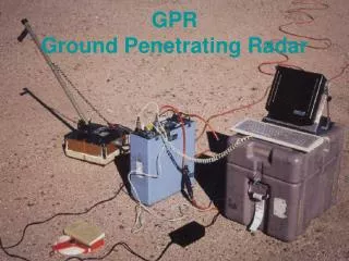
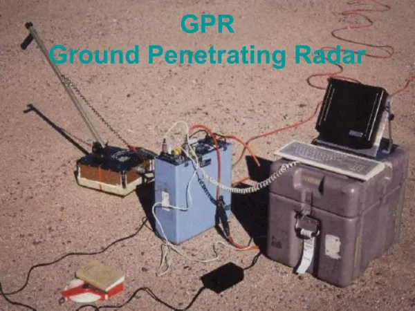
Ground-Penetrating Radar (GPR) • Mine Hunter/Killer: Designed by BAE; • $:Army Night Vision Lab (Fort Belvoir VA) • 20 transmit/receive antenna pairs in front • 256 frequencies; 500 Mhz to about 2 MHz; stepped by 5 MHz
Depth Processing of Data • Continuous-wave stepped-frequency response • Direct measurement of transfer function • Sample every 2 inches in vehicle motion direction
Fourier Transform (FFT) • Response(frequency) is r(f): • Dwell time (one f)=0.15us; • Penetration depth=7m (ε=9) • Step size so no depth aliasing=1.1 MHz
Hyperbola: azimuth (along track) Buried point target located at (x0,z0). Antenna located along track at (x,0).
Significance of Hyperbola • Avoids false alarms due to clutter and noise • Stratified ground appears as straight line • Hyperbola indicates real, localized target • Hyperbola indicates its depth, as well
Range Migration Algorithm (RMA) • Originally: Seismic imaging for oil domes • “Migration” since images in raw data are “migrated” to their correct locations • Later: adapted to SAR by Italians • Frequency-domain migration: 1978 (Stolt)
Range Migration Equations D(kx,kz)=R(kx,w)=2-D space-time Fourier of r(x,t)
Experimental Validation: Data • TM-62M anti-tank mine; buried 4”-8” • 6” high=3 pixels@2” for 500 MHz-2 GHz • Measured signature in Virginia clay (lossy) from MH/K above • System calibration off
Experimental Validation: Result Image: top and bottom of mine (7” apart, 10” long) Shadow region between (radar can’t penetrate mine) Depth of top line=6”=correct depth of buried mine Need to estimate permittivity so flat top & bottom Thresholding for binary image makes image clearer
Experimental Validation: Result 10 signatures from same TM-62M mine using MH/K Fairly consistent (a few outliers); biased slightly high Unknown ground truth permittivity a likely problem: Different in free space, underground, in mine itself
Present Work on Landmines • Issue: detection performance post-migration (easier to look for parallel straight lines) vs. detection performance w/pre-migration data (harder to look for hyperbolae, but apply to raw data before migration processing) • Issue: how to look for lines or hyperbolae • Issue: how to combine with other modalities
OBJECTIVE ILLUSTRATION Determine size and depth of landmines using GPR as part of a multimodal detection algorithm APPROACH ACCOMPLISHMENTS Range Migration and phase compensation; Stoltz interpolation Successful detection of Russian mines buried in field from NVESD MH/K
RANGE MIGRATION ALGORITHM: EXPERIMENT USSR TM-62 LAND MINE Army NVESD MH/K Imaging a single point Point-spread response
RANGE MIGRATION ALGORITHM: RESULTS TM-62 measured (6” depth) TM-62 binary reconstructed