Download
1 / 33
340 likes | 576 Views
Geographical Information Systems (GIS). Week 3 (21/02/07). © Richard Haddlesey www.medievalarchitecture.net. Lecture aims. To build on the concepts of DBMS learnt in previous lectures and to apply geo-referencing to them To familiarise the student with the concepts of a GIS

E N D
Geographical Information Systems (GIS) Week 3 (21/02/07) © Richard Haddlesey www.medievalarchitecture.net
Lecture aims • To build on the concepts of DBMS learnt in previous lectures and to apply geo-referencing to them • To familiarise the student with the concepts of a GIS • To learn the key features of using ArcGIS 9
programme • Week 3 • Define what we mean by GIS and why it is useful in archaeology • Discuss the development of GIS in archaeology • Discuss appropriate hardware and software systems, their advantages and disadvantages • Introduce co-ordinate systems • Provide some background to the module case study
Programme • WEEKS 4-7 • Consider Raster and Vector graphics • Discuss the use of databases in GIS • Examine 3D applications
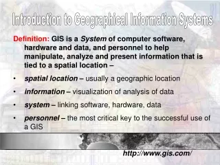
What is a GIS? • Geographical Information Systems / Science • "... a powerful set of tools for collecting, storing, retrieving at will, transforming, and displaying spatial data from the real world for a particular set of purposes." (Burrough 1986) • A GIS is a computer system capable of capturing, storing, analyzing, and displaying geographically referenced information; that is, data identified according to location. (USGS website (02/2007))
What is a GIS? • Spatially referenced database (geodatabase) • Integrating technology • Computer Aided Mapping / Computer Aided Cartography • Image Processing, particularly of remote sensed data • Computer graphics / data visualisation • Spatial analysis and statistical software • Database technology
What a GIS is not • A software package • A map • A GPS (Global Positioning System)
Key GIS Concepts • A geographic information system is a system for the management, analysis, and display of geographic data • Maps and globes • Geodatabases (DBMS) • Logic workflows • metadata
Key GIS Concepts Marble (1987) defined four subsystems: Data Entry handles all the translation of raw or partially processed spatial data into an input stream of known and carefully controlled characteristics, Data Storage and Retrieval subsystem or spatial database. This is responsible for storing spatial, topological and attribute information, and maintaining links with external database systems, Manipulation and Analysis takes care of all data transformations, and carries out spatial analysis and modelling functions, Visualisation and Reporting subsystem returns the results of queries and analyses to the user in the form of maps and other graphics as well as text. We might also add a 5. User interface to this list
The importance of GIS • The British Government (Dept. of the Environment) stated in 1988 that the impact of GIS on spatial analysis was as significant as ........ “the invention of the microscope and telescope were to science, the computer to economics and the printing press to information dissemination. It is the biggest step forward in the handling of geographic information since the invention of the map”
Why use GIS in archaeology? • Archaeology is a spatial discipline • We work in all 3 dimensions • It allows us to re-examine past theories • Allows us to analyse several maps in one easy package and select specific data attributes using layers
Adoption of GIS in archaeology • Adopted by US archaeologists, mainly CRM (e.g. Kvamme) for ‘Predictive modelling’ of site locations • Reflects type of the archaeological work and theoretical orientation • Still a major topic of investigation in the US e.g. Westcott & Brandon Adoption • later in the UK, then other European countries • In Europe, the impetus for GIS adoption was more from researchers than managers • Little interest in predictive models • Far more ‘analytical’ uses of technology • Potential for GIS for archaeological management quickly realised, although implementation remains limited
How do we communicate the location of something to another person? What happens if that place is not in Britain? Jones 1997, chapter 4
Cartesian co-ordinates Polar Planar co-ordinates Northing Distance Angle Easting Co-ordinate systems (1) You will be familiar with two co-ordinate systems:
Co-ordinate systems (2) Both the previous two systems are fine over short distances as both assume the world is flat Meridian Parallel
Co-ordinate systems (3) Map Projections: transforming a representation of the world in 3D to a representation on a planar surface The Mercator projection has straight meridians and parallels that intersect at right angles. Scale is true at the equator or at two standard parallels equidistant from the equator. The projection is often used for marine navigation because all straight lines on the map are lines of constant azimuth
Co-ordinate systems (4) Transverse Mercator projections Transverse Mercator projections result from projecting the sphere onto a cylinder tangent to a central meridian. Transverse Mercator maps are often used to portray areas with larger north-south than east-west extent. Distortion of scale, distance, direction and area increase away from the central meridian. Scale 0.996 49o N, 2oW
Co-ordinate systems (5) Transverse Mercator projections The Universal Transverse Mercator (UTM) projection is used to define horizontal positions world-wide by dividing the surface of the Earth into 6 degree zones, each mapped by the Transverse Mercator projection with a central meridian in the centre of the zone. UTM zone numbers designate 6 degree longitudinal strips extending from 80 degrees South latitude to 84 degrees North latitude. UTM zone characters designate 8 degree zones extending north and south from the equator
Co-ordinate systems (6) Any problems with projections? The shape of the Earth (geoid) has been refined a number of times. Each change affects all projected co-ordinate systems